TARA Tarawa Island, Republic of Kiribati - Earthquake Result Viewer
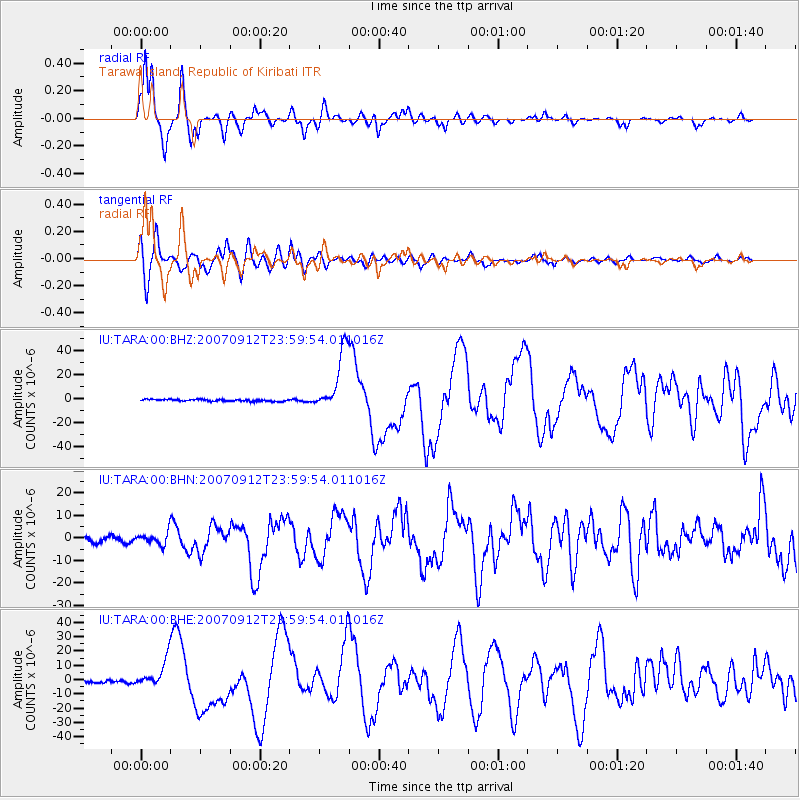
Earthquake location: Southern Sumatra, Indonesia
Earthquake latitude/longitude: -2.6/100.8
Earthquake time(UTC): 2007/09/12 (255) 23:49:03 GMT
Earthquake Depth: 35 km
Earthquake Magnitude: 6.6 MB, 8.1 MS, 7.9 MW, 7.6 ME
Earthquake Catalog/Contributor: WHDF/NEIC
Network: IU Global Seismograph Network (GSN - IRIS/USGS)
Station: TARA Tarawa Island, Republic of Kiribati
Lat/Lon: 1.35 N/172.92 E
Elevation: 4.0 m
Distance: 72.2 deg
Az: 87.745 deg
Baz: 266.827 deg
Ray Param: 0.053784873
Estimated Moho Depth: 12.75 km
Estimated Crust Vp/Vs: 1.65
Assumed Crust Vp: 4.802 km/s
Estimated Crust Vs: 2.901 km/s
Estimated Crust Poisson's Ratio: 0.21
Radial Match: 96.68364 %
Radial Bump: 339
Transverse Match: 92.77485 %
Transverse Bump: 400
SOD ConfigId: 2564
Insert Time: 2010-03-04 16:12:51.029 +0000
GWidth: 2.5
Max Bumps: 400
Tol: 0.001

Signal To Noise

ChannelStoNSTALTA
IU:TARA:00:BHN:20070912T23:59:54.011016Z2.46389252.6786818E-61.0871748E-6
IU:TARA:00:BHE:20070912T23:59:54.011016Z11.0800189.686852E-68.7426315E-7
IU:TARA:00:BHZ:20070912T23:59:54.011016Z32.6199532.5451274E-57.802364E-7
Arrivals
Ps1.8 SECOND
PpPs6.9 SECOND
PsPs/PpSs8.7 SECOND