You are here: Home > Network List > IU - Global Seismograph Network (GSN - IRIS/USGS) Stations List
> Station TARA Tarawa Island, Republic of Kiribati > Earthquake Result Viewer
TARA Tarawa Island, Republic of Kiribati - Earthquake Result Viewer
| Earthquake location: |
Java, Indonesia |
| Earthquake latitude/longitude: |
-5.9/107.7 |
| Earthquake time(UTC): |
2007/08/08 (220) 17:04:57 GMT |
| Earthquake Depth: |
291 km |
| Earthquake Magnitude: |
6.1 MB |
| Earthquake Catalog/Contributor: |
WHDF/NEIC |
|
| Network: |
IU Global Seismograph Network (GSN - IRIS/USGS) |
| Station: |
TARA Tarawa Island, Republic of Kiribati |
| Lat/Lon: |
1.35 N/172.92 E |
| Elevation: |
4.0 m |
|
| Distance: |
65.5 deg |
| Az: |
85.823 deg |
| Baz: |
262.912 deg |
| Ray Param: |
0.05728654 |
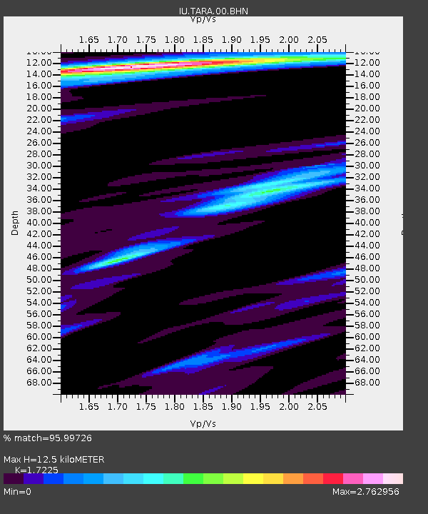
| Estimated Moho Depth: |
12.5 km |
| Estimated Crust Vp/Vs: |
1.72 |
| Assumed Crust Vp: |
4.802 km/s |
| Estimated Crust Vs: |
2.788 km/s |
| Estimated Crust Poisson's Ratio: |
0.25 |
|
| Radial Match: |
95.99726 % |
| Radial Bump: |
334 |
| Transverse Match: |
91.87042 % |
| Transverse Bump: |
400 |
| SOD ConfigId: |
2564 |
| Insert Time: |
2010-03-04 16:12:54.803 +0000 |
| GWidth: |
2.5 |
| Max Bumps: |
400 |
| Tol: |
0.001 |
|

Signal To Noise
| Channel | StoN | STA | LTA |
| IU:TARA:00:BHN:20070808T17:14:39.660007Z | 0.7614487 | 3.9119098E-7 | 5.137457E-7 |
| IU:TARA:00:BHE:20070808T17:14:39.660007Z | 2.2873986 | 1.3000094E-6 | 5.683354E-7 |
| IU:TARA:00:BHZ:20070808T17:14:39.660007Z | 2.963809 | 1.1265735E-6 | 3.8011E-7 |
| Arrivals |
| Ps | 1.9 SECOND |
| PpPs | 6.9 SECOND |
| PsPs/PpSs | 8.9 SECOND |


