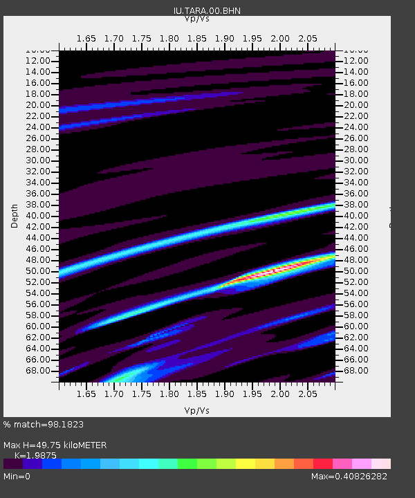
TARA Tarawa Island, Republic of Kiribati - Earthquake Result Viewer

Earthquake location: Talaud Islands, Indonesia
Earthquake latitude/longitude: 3.7/126.6
Earthquake time(UTC): 2009/02/22 (053) 17:45:22 GMT
Earthquake Depth: 32 km
Earthquake Magnitude: 5.9 MB, 5.7 MS, 6.0 MW, 6.0 MW
Earthquake Catalog/Contributor: WHDF/NEIC
Network: IU Global Seismograph Network (GSN - IRIS/USGS)
Station: TARA Tarawa Island, Republic of Kiribati
Lat/Lon: 1.35 N/172.92 E
Elevation: 4.0 m
Distance: 46.4 deg
Az: 91.626 deg
Baz: 273.766 deg
Ray Param: 0.07062663
Estimated Moho Depth: 49.75 km
Estimated Crust Vp/Vs: 1.99
Assumed Crust Vp: 4.802 km/s
Estimated Crust Vs: 2.416 km/s
Estimated Crust Poisson's Ratio: 0.33
Radial Match: 98.1823 %
Radial Bump: 101
Transverse Match: 87.71557 %
Transverse Bump: 190
SOD ConfigId: 2658
Insert Time: 2010-03-04 16:13:03.747 +0000
GWidth: 2.5
Max Bumps: 400
Tol: 0.001

Signal To Noise

ChannelStoNSTALTA
IU:TARA:00:BHN:20090222T17:53:15.009985Z0.219660976.401625E-82.914321E-7
IU:TARA:00:BHE:20090222T17:53:15.009985Z0.19895739.5637915E-94.806957E-8
IU:TARA:00:BHZ:20090222T17:53:15.009985Z0.177868682.982577E-81.6768422E-7
Arrivals
Ps11 SECOND
PpPs30 SECOND
PsPs/PpSs41 SECOND