You are here: Home > Network List > IU - Global Seismograph Network (GSN - IRIS/USGS) Stations List
> Station TARA Tarawa Island, Republic of Kiribati > Earthquake Result Viewer
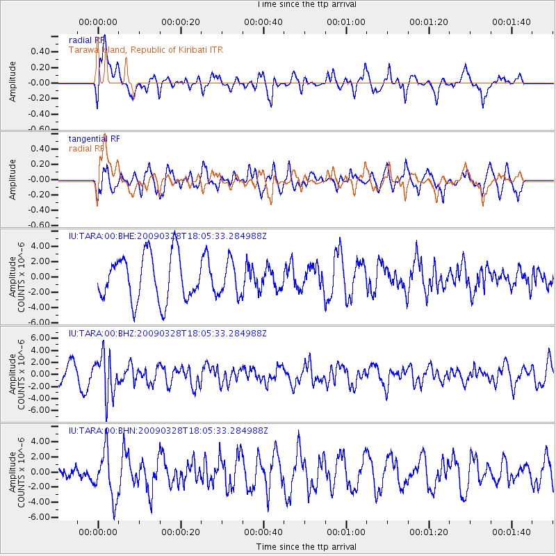
TARA Tarawa Island, Republic of Kiribati - Earthquake Result Viewer
*The percent match for this event was below the threshold and hence no stack was calculated.
| Earthquake location: |
Near North Coast Of Irian Jaya |
| Earthquake latitude/longitude: |
-3.0/139.5 |
| Earthquake time(UTC): |
2009/03/28 (087) 17:59:32 GMT |
| Earthquake Depth: |
96 km |
| Earthquake Magnitude: |
5.8 MB, 6.0 MW, 6.0 MW |
| Earthquake Catalog/Contributor: |
WHDF/NEIC |
|
| Network: |
IU Global Seismograph Network (GSN - IRIS/USGS) |
| Station: |
TARA Tarawa Island, Republic of Kiribati |
| Lat/Lon: |
1.35 N/172.92 E |
| Elevation: |
4.0 m |
|
| Distance: |
33.6 deg |
| Az: |
83.135 deg |
| Baz: |
262.658 deg |
| Ray Param: |
$rayparam |
*The percent match for this event was below the threshold and hence was not used in the summary stack. |
|
| Radial Match: |
46.133305 % |
| Radial Bump: |
400 |
| Transverse Match: |
60.95746 % |
| Transverse Bump: |
400 |
| SOD ConfigId: |
2658 |
| Insert Time: |
2010-03-04 16:13:36.107 +0000 |
| GWidth: |
2.5 |
| Max Bumps: |
400 |
| Tol: |
0.001 |
|
Signal To Noise
| Channel | StoN | STA | LTA |
| IU:TARA:00:BHZ:20090328T18:05:33.284988Z | 2.231934 | 3.42986E-6 | 1.536721E-6 |
| IU:TARA:00:BHN:20090328T18:05:33.284988Z | 2.0927618 | 3.2660603E-6 | 1.560646E-6 |
| IU:TARA:00:BHE:20090328T18:05:33.284988Z | 0.74199396 | 2.2173388E-6 | 2.9883515E-6 |
| Arrivals |
| Ps | |
| PpPs | |
| PsPs/PpSs | |


