You are here: Home > Network List > TA - USArray Transportable Network (new EarthScope stations) Stations List
> Station L65A Cape Cod National Seashore, MA, USA > Earthquake Result Viewer
L65A Cape Cod National Seashore, MA, USA - Earthquake Result Viewer
| Earthquake location: |
Near Coast Of Central Chile |
| Earthquake latitude/longitude: |
-31.6/-71.8 |
| Earthquake time(UTC): |
2015/09/16 (259) 22:54:31 GMT |
| Earthquake Depth: |
12 km |
| Earthquake Magnitude: |
8.3 MWW, 7.9 MI |
| Earthquake Catalog/Contributor: |
NEIC PDE/NEIC COMCAT |
|
| Network: |
TA USArray Transportable Network (new EarthScope stations) |
| Station: |
L65A Cape Cod National Seashore, MA, USA |
| Lat/Lon: |
42.03 N/70.05 W |
| Elevation: |
50 m |
|
| Distance: |
73.3 deg |
| Az: |
1.322 deg |
| Baz: |
181.514 deg |
| Ray Param: |
0.053113367 |
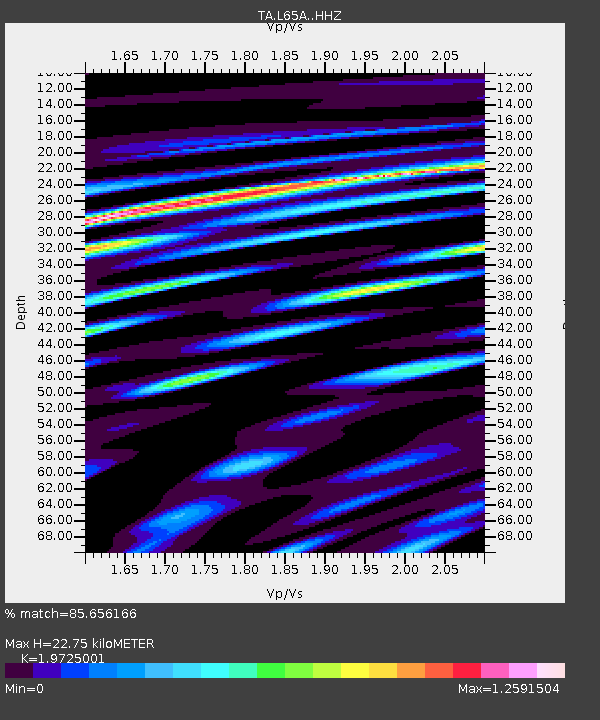
| Estimated Moho Depth: |
22.75 km |
| Estimated Crust Vp/Vs: |
1.97 |
| Assumed Crust Vp: |
6.419 km/s |
| Estimated Crust Vs: |
3.254 km/s |
| Estimated Crust Poisson's Ratio: |
0.33 |
|
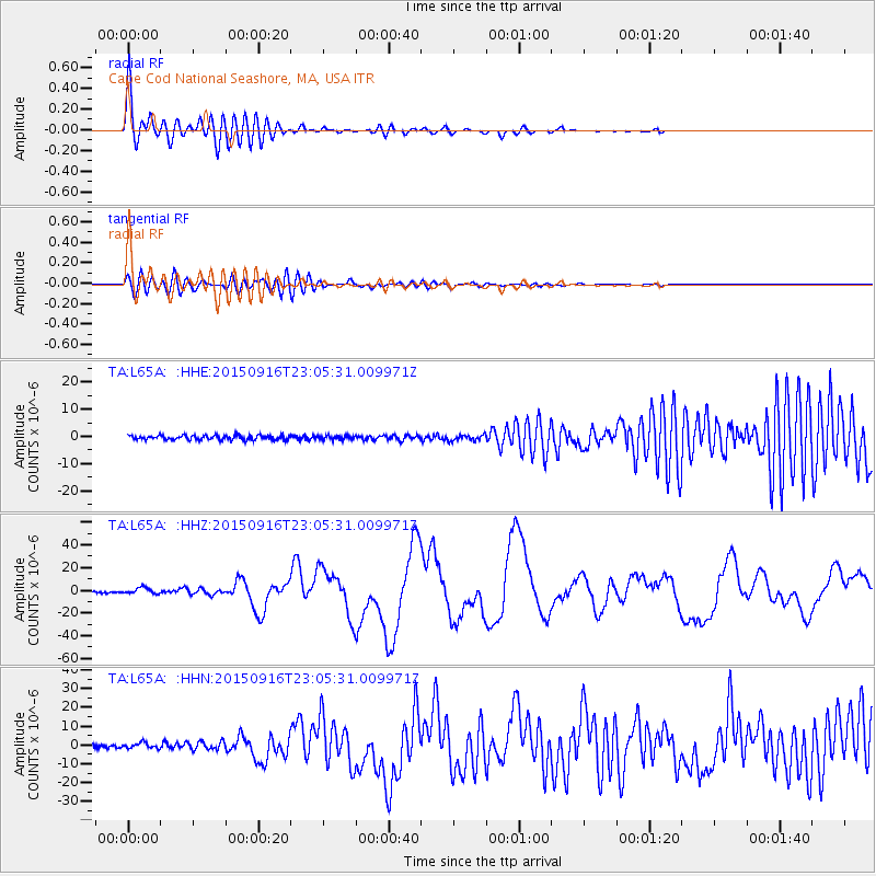
| Radial Match: |
85.656166 % |
| Radial Bump: |
400 |
| Transverse Match: |
44.094147 % |
| Transverse Bump: |
400 |
| SOD ConfigId: |
7422571 |
| Insert Time: |
2019-04-20 19:06:02.509 +0000 |
| GWidth: |
2.5 |
| Max Bumps: |
400 |
| Tol: |
0.001 |
|
Signal To Noise
| Channel | StoN | STA | LTA |
| TA:L65A: :HHZ:20150916T23:05:31.009971Z | 5.961002 | 2.6664266E-6 | 4.4731183E-7 |
| TA:L65A: :HHN:20150916T23:05:31.009971Z | 2.1129496 | 1.4610878E-6 | 6.91492E-7 |
| TA:L65A: :HHE:20150916T23:05:31.009971Z | 0.83277005 | 6.8259675E-7 | 8.196701E-7 |
| Arrivals |
| Ps | 3.6 SECOND |
| PpPs | 10 SECOND |
| PsPs/PpSs | 14 SECOND |


