You are here: Home > Network List > IU - Global Seismograph Network (GSN - IRIS/USGS) Stations List
> Station TBT Taburiente, Canary Islands, Spain > Earthquake Result Viewer
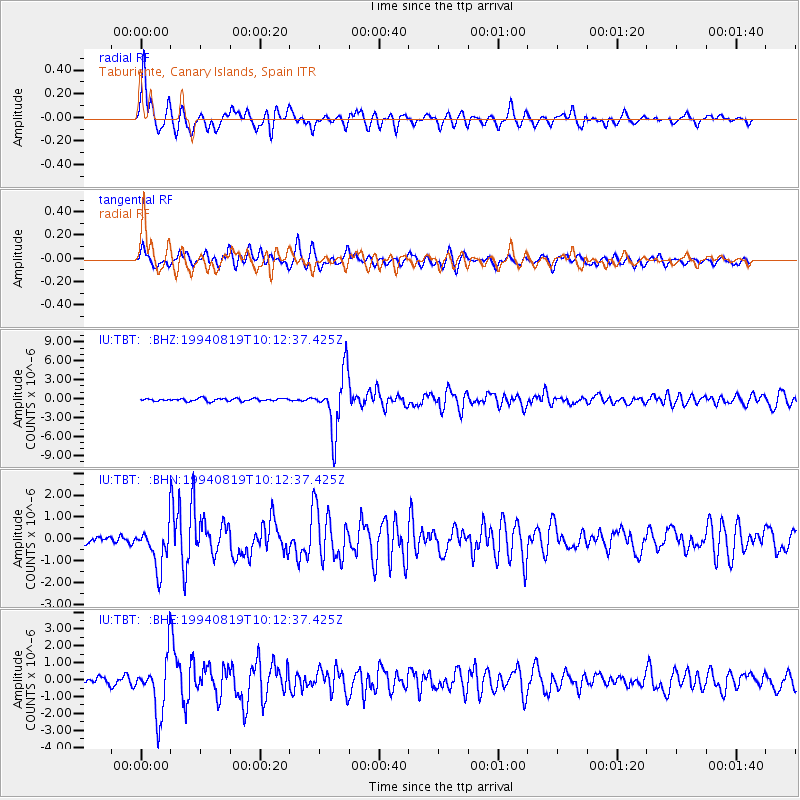
TBT Taburiente, Canary Islands, Spain - Earthquake Result Viewer

| Earthquake location: |
Santiago Del Estero Prov., Arg. |
| Earthquake latitude/longitude: |
-26.7/-63.4 |
| Earthquake time(UTC): |
1994/08/19 (231) 10:02:51 GMT |
| Earthquake Depth: |
565 km |
| Earthquake Magnitude: |
6.4 MB, 6.5 UNKNOWN, 6.5 MW |
| Earthquake Catalog/Contributor: |
WHDF/NEIC |
|
| Network: |
IU Global Seismograph Network (GSN - IRIS/USGS) |
| Station: |
TBT Taburiente, Canary Islands, Spain |
| Lat/Lon: |
28.68 N/17.91 W |
| Elevation: |
180 m |
|
| Distance: |
70.2 deg |
| Az: |
41.729 deg |
| Baz: |
222.683 deg |
| Ray Param: |
0.05320269 |
| Estimated Moho Depth: |
12.75 km |
| Estimated Crust Vp/Vs: |
1.61 |
| Assumed Crust Vp: |
4.662 km/s |
| Estimated Crust Vs: |
2.896 km/s |
| Estimated Crust Poisson's Ratio: |
0.19 |
|
| Radial Match: |
89.186745 % |
| Radial Bump: |
393 |
| Transverse Match: |
81.97675 % |
| Transverse Bump: |
400 |
| SOD ConfigId: |
16938 |
| Insert Time: |
2010-03-04 19:40:48.137 +0000 |
| GWidth: |
2.5 |
| Max Bumps: |
400 |
| Tol: |
0.001 |
|
Signal To Noise
| Channel | StoN | STA | LTA |
| IU:TBT: :BHN:19940819T10:12:37.425Z | 4.452211 | 9.300705E-7 | 2.0890083E-7 |
| IU:TBT: :BHE:19940819T10:12:37.425Z | 9.344139 | 1.6847644E-6 | 1.8030173E-7 |
| IU:TBT: :BHZ:19940819T10:12:37.425Z | 21.762424 | 4.5488086E-6 | 2.0902122E-7 |
| Arrivals |
| Ps | 1.7 SECOND |
| PpPs | 7.0 SECOND |
| PsPs/PpSs | 8.7 SECOND |


