
Station IU TBT - Taburiente, Canary Islands, Spain
Network: IU - Global Seismograph Network (GSN - IRIS/USGS)
Nearby stations (2 deg radius)
| Station | Name | (Lat, Lon) | Start / End | Elevation |
| TBT | Taburiente, Canary Islands, Spain | (28.68, -17.91) | 1993-03-17 / 1996-08-22 | 180 m |
| Crust2 Type: | B2,melt affected o.c. and oceanic plateaus, 1 km seds. |
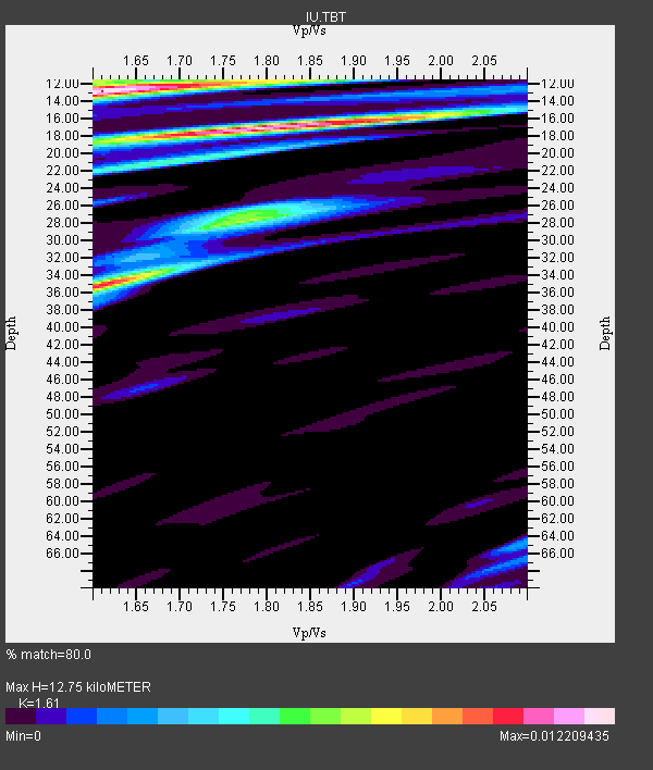
| Thickness Estimate: | 13 km |
| Thickness StdDev: | 9.7 km |
| Vp/Vs Estimate: | 1.61 |
| Vp/Vs StdDev: | 0.11 |
| Vs Estimate: | 2.896 km/s |
| Poisson's Ratio: | 0.19 |
| Peak Value: | 0.01 |
| Assumed Vp: | 4.662 km/s |
| Ps Weight: | 0.33333334 |
| PpPs Weight: | 0.33333334 |
| PsPs Weight: | 0.33333328 |
| Residual Complexity: | 0.841 |
| Nearby stations H: | +- |
| (2.0 deg) Vp/Vs: | +- |
5 with match > 90% ( 15.625 %) and 15 with match > 80% ( 46.875 %) out of 32.
Download stack as xyz text file.
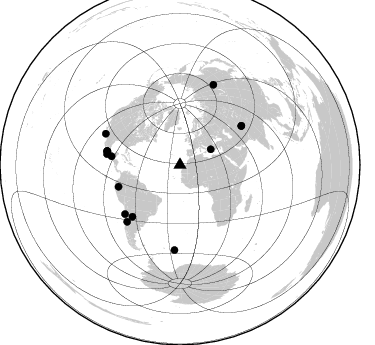
Azimuth Distribution of Events:
Prior Results for this Station
| Study | Thickness | Vp/Vs | Vp | Vs | Poissons Ratio | Extra |
| EARS | 13 km | 1.61 | 4.662 km/s | 2.896 km/s | 0.19 | |
| Crust2.0 | 16 km | 2.05 | 4.662 km/s | 2.269 km/s | 0.34 | B2,melt affected o.c. and oceanic plateaus, 1 km seds. |
| Global Maxima | 13 km | 1.61 | 4.662 km/s | 2.896 km/s | 0.19 | amp=0.012209435 |
| Local Maxima 1 | 17 km | 1.79 | 4.662 km/s | 2.601 km/s | 0.27 | amp=0.0117049245 |
| Local Maxima 2 | 35 km | 1.61 | 4.662 km/s | 2.891 km/s | 0.19 | amp=0.009964201 |
| Local Maxima 3 | 28 km | 1.79 | 4.662 km/s | 2.608 km/s | 0.27 | amp=0.005499066 |
| Local Maxima 4 | 20 km | 1.72 | 4.662 km/s | 2.719 km/s | 0.24 | amp=0.005087255 |
| Predicted Arrivals for vertical incidence (zero ray parameter) | |
| Ps | 1.67 SECOND |
| PpPs | 7.14 SECOND |
| PsPs/PpSs | 8.81 SECOND |
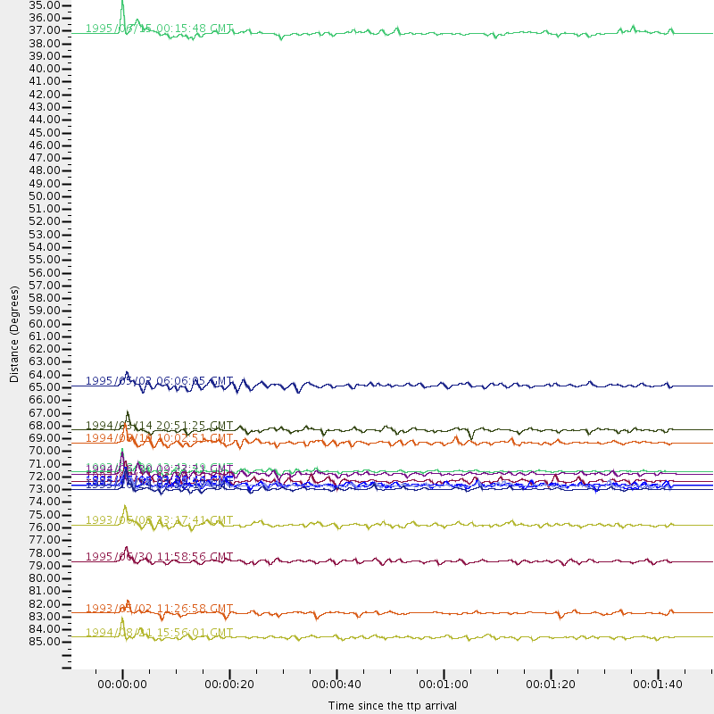
Events Processed for this Station
Download zip of receiver functions as SAC
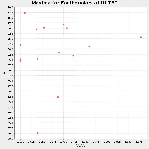
Plot maxima for each earthquake.
Events Used in the Stack
(15 events)| Radial Match | Distance | Baz | FERegion | Time | Lat/Lon | Depth | Magnitude |
| 97.212555 | 74.3 deg | 280.721 deg | Near Coast Of Guerrero, Mexico | 1993/10/24 07:52:17 GMT | (16.8, -98.7) | 32 km | 6.2 MB, 6.6 MS, 6.5 UNKNOWN, 6.8 MW |
| 91.81877 | 72.7 deg | 57.69 deg | Hindu Kush Region, Afghanistan | 1993/08/09 12:42:49 GMT | (36.4, 70.9) | 230 km | 6.3 MB, 6.9 UNKNOWN |
| 90.88311 | 85.0 deg | 183.751 deg | South Sandwich Islands Region | 1993/05/02 11:26:58 GMT | (-56.5, -24.7) | 33 km | 6.2 MB, 6.4 MS, 6.2 UNKNOWN |
| 90.668015 | 87.1 deg | 22.702 deg | East Of Lake Baykal, Russia | 1994/08/21 15:56:01 GMT | (56.7, 117.8) | 33 km | 5.7 MB, 5.8 MS, 6.0 UNKNOWN, 6.0 MW |
| 90.13588 | 74.0 deg | 280.528 deg | Near Coast Of Guerrero, Mexico | 1993/05/15 03:12:33 GMT | (16.7, -98.4) | 28 km | 5.9 MB, 5.9 MS |
| 89.80766 | 80.5 deg | 292.778 deg | Baja California, Mexico | 1995/06/30 11:58:56 GMT | (24.6, -110.3) | 10 km | 5.8 MB, 6.3 MS, 6.2 UNKNOWN |
| 89.186745 | 70.2 deg | 222.683 deg | Santiago Del Estero Prov., Arg. | 1994/08/19 10:02:51 GMT | (-26.7, -63.4) | 565 km | 6.4 MB, 6.5 UNKNOWN, 6.5 MW |
| 86.35881 | 77.3 deg | 223.058 deg | San Juan Province, Argentina | 1993/06/08 23:17:41 GMT | (-31.6, -69.2) | 113 km | 6.4 MB, 6.4 UNKNOWN |
| 85.93688 | 73.8 deg | 278.399 deg | Off Coast Of Oaxaca, Mexico | 1994/07/04 21:36:44 GMT | (14.9, -97.3) | 33 km | 6.1 MB, 6.1 MS, 6.5 UNKNOWN, 6.5 MD |
| 85.59667 | 73.5 deg | 228.255 deg | Near Coast Of Northern Chile | 1993/07/11 13:36:19 GMT | (-25.4, -70.2) | 33 km | 6.2 MB, 6.0 MS, 5.8 UNKNOWN, 6.8 MW |
| 85.17228 | 72.9 deg | 57.719 deg | Afghanistan-Tajikistan Bord Reg. | 1994/06/30 09:23:21 GMT | (36.3, 71.1) | 233 km | 6.1 MB, 6.4 UNKNOWN, 6.2 MW |
| 85.163086 | 73.9 deg | 280.596 deg | Near Coast Of Guerrero, Mexico | 1993/05/15 03:09:40 GMT | (16.8, -98.4) | 27 km | 5.8 MB, 5.8 MS, 5.7 UNKNOWN |
| 83.816696 | 69.1 deg | 277.229 deg | Mexico-Guatemala Border Region | 1994/03/14 20:51:25 GMT | (16.0, -92.4) | 169 km | 5.9 MB, 6.2 MS, 6.9 UNKNOWN, 6.2 MD |
| 82.47148 | 34.6 deg | 63.122 deg | Greece | 1995/06/15 00:15:48 GMT | (38.4, 22.3) | 14 km | 6.0 MB, 6.5 MS, 6.5 UNKNOWN, 5.7 ML |
| 82.44133 | 65.2 deg | 250.458 deg | Northern Peru | 1995/05/02 06:06:05 GMT | (-3.9, -77.0) | 103 km | 6.5 MB, 6.7 UNKNOWN, 6.6 MW |
Losers
(17 events)| Radial Match | Distance | Baz | FERegion | Time | Lat/Lon | Depth | Magnitude | Reason |
| 79.23962 | 40.1 deg | 261.676 deg | Leeward Islands | 1995/03/08 03:45:59 GMT | (16.6, -59.6) | 15 km | 6.3 MB, 6.2 MS, 6.4 UNKNOWN, 6.1 MD | |
| 77.493576 | 64.9 deg | 237.215 deg | Peru-Bolivia Border Region | 1994/01/10 15:53:49 GMT | (-13.3, -69.4) | 589 km | 6.4 MB, 6.4 UNKNOWN, 6.9 MW | |
| 71.22714 | 69.4 deg | 243.389 deg | Central Peru | 1993/04/18 09:16:21 GMT | (-11.6, -76.6) | 90 km | 6.1 MB, 5.8 UNKNOWN | |
| 70.94259 | 72.6 deg | 57.679 deg | Hindu Kush Region, Afghanistan | 1993/08/09 11:38:31 GMT | (36.4, 70.7) | 210 km | 5.8 MB, 6.3 UNKNOWN, 6.2 MW | |
| 70.45809 | 72.2 deg | 229.914 deg | Near Coast Of Northern Chile | 1995/07/30 05:47:02 GMT | (-23.3, -70.3) | 33 km | 5.8 MB | |
| 68.66766 | 67.9 deg | 233.977 deg | Peru-Bolivia Border Region | 1994/12/12 07:41:55 GMT | (-17.5, -69.7) | 151 km | 5.8 MB, 6.1 UNKNOWN, 6.3 MW | |
| 65.34587 | 73.2 deg | 309.817 deg | Wyoming | 1994/02/03 09:05:03 GMT | (42.8, -111.0) | 5.0 km | 5.6 MS, 5.4 MB, 5.9 UNKNOWN, 5.8 ML | |
| 62.473064 | 79.0 deg | 224.043 deg | Near Coast Of Central Chile | 1994/10/11 01:37:20 GMT | (-32.1, -71.4) | 51 km | 5.6 MB, 5.3 MS, 5.8 UNKNOWN, 5.4 MD | |
| 61.130848 | 68.8 deg | 227.648 deg | Jujuy Province, Argentina | 1993/10/19 04:02:22 GMT | (-22.4, -66.0) | 278 km | 5.8 MB, 5.4 UNKNOWN, 6.0 MW | |
| 58.475178 | 73.8 deg | 279.856 deg | Oaxaca, Mexico | 1996/02/25 03:08:18 GMT | (16.2, -98.0) | 33 km | 5.9 MB, 6.9 MS, 7.1 UNKNOWN, 7.0 MW | |
| 57.30493 | 66.9 deg | 236.333 deg | Southern Peru | 1994/06/16 18:41:31 GMT | (-15.2, -70.3) | 225 km | 5.6 MB, 5.8 UNKNOWN, 6.1 MW | |
| 54.95602 | 63.9 deg | 241.929 deg | Peru-Brazil Border Region | 1994/11/04 01:13:20 GMT | (-9.3, -71.3) | 598 km | 5.8 MB, 5.9 UNKNOWN, 6.2 MW | |
| 48.944775 | 78.5 deg | 224.882 deg | Near Coast Of Central Chile | 1994/09/12 06:29:56 GMT | (-31.1, -71.6) | 53 km | 5.8 MB, 6.0 UNKNOWN, 5.5 MD | |
| 45.822567 | 66.7 deg | 66.588 deg | Northern And Central Iran | 1994/02/24 00:11:12 GMT | (30.8, 60.5) | 13 km | 6.0 MB, 6.1 MS, 6.3 UNKNOWN, 6.1 MW | |
| 45.291904 | 83.6 deg | 218.575 deg | Southern Argentina | 1994/10/20 01:15:16 GMT | (-39.2, -70.8) | 164 km | 5.7 MB, 5.9 UNKNOWN, 6.2 MW | |
| 45.264187 | 63.5 deg | 242.806 deg | Western Brazil | 1993/05/06 13:03:19 GMT | (-8.5, -71.5) | 586 km | 5.8 MB, 5.8 UNKNOWN | |
| 42.895477 | 91.1 deg | 339.787 deg | Alaska Peninsula | 1995/03/14 17:33:50 GMT | (54.8, -161.3) | 33 km | 6.1 MB, 5.9 MS, 6.2 UNKNOWN, 5.5 ML |
