You are here: Home > Network List > IU - Global Seismograph Network (GSN - IRIS/USGS) Stations List
> Station TBT Taburiente, Canary Islands, Spain > Earthquake Result Viewer
TBT Taburiente, Canary Islands, Spain - Earthquake Result Viewer
| Earthquake location: |
Baja California, Mexico |
| Earthquake latitude/longitude: |
24.6/-110.3 |
| Earthquake time(UTC): |
1995/06/30 (181) 11:58:56 GMT |
| Earthquake Depth: |
10 km |
| Earthquake Magnitude: |
5.8 MB, 6.3 MS, 6.2 UNKNOWN |
| Earthquake Catalog/Contributor: |
WHDF/NEIC |
|
| Network: |
IU Global Seismograph Network (GSN - IRIS/USGS) |
| Station: |
TBT Taburiente, Canary Islands, Spain |
| Lat/Lon: |
28.68 N/17.91 W |
| Elevation: |
180 m |
|
| Distance: |
80.5 deg |
| Az: |
62.89 deg |
| Baz: |
292.778 deg |
| Ray Param: |
0.048232775 |
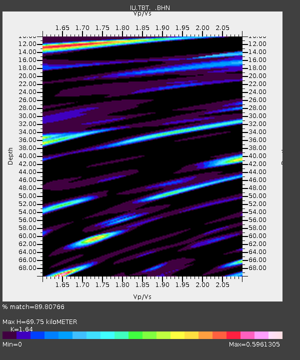
| Estimated Moho Depth: |
69.75 km |
| Estimated Crust Vp/Vs: |
1.64 |
| Assumed Crust Vp: |
4.662 km/s |
| Estimated Crust Vs: |
2.843 km/s |
| Estimated Crust Poisson's Ratio: |
0.20 |
|
| Radial Match: |
89.80766 % |
| Radial Bump: |
400 |
| Transverse Match: |
83.52255 % |
| Transverse Bump: |
400 |
| SOD ConfigId: |
6273 |
| Insert Time: |
2010-03-04 19:40:51.844 +0000 |
| GWidth: |
2.5 |
| Max Bumps: |
400 |
| Tol: |
0.001 |
|

Signal To Noise
| Channel | StoN | STA | LTA |
| IU:TBT: :BHN:19950630T12:10:37.123999Z | 1.2507685 | 1.1383575E-7 | 9.101264E-8 |
| IU:TBT: :BHE:19950630T12:10:37.123999Z | 1.00679 | 1.0952503E-7 | 1.08786374E-7 |
| IU:TBT: :BHZ:19950630T12:10:37.123999Z | 1.9050665 | 2.7976088E-7 | 1.4685098E-7 |
| Arrivals |
| Ps | 9.7 SECOND |
| PpPs | 39 SECOND |
| PsPs/PpSs | 49 SECOND |


