
Station GE BOA - GEOFON Station Boaco, Nicaragua
Network: GE - GEOFON
Nearby stations (2 deg radius)
| Station | Name | (Lat, Lon) | Start / End | Elevation |
| BOA | GEOFON Station Boaco, Nicaragua | (12.45, -85.67) | 1999-11-11 / 2499-01-01 | 381 m |
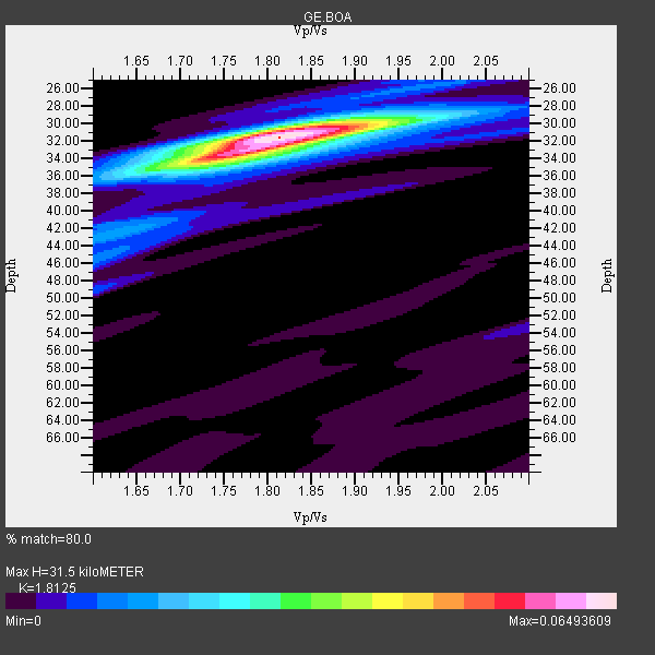
| Crust2 Type: | L3,continental arc, Southern Andes, 0.2 km seds. |
| Thickness Estimate: | 32 km |
| Thickness StdDev: | 0.8 km |
| Vp/Vs Estimate: | 1.81 |
| Vp/Vs StdDev: | 0.02 |
| Vs Estimate: | 3.64 km/s |
| Poisson's Ratio: | 0.28 |
| Peak Value: | 0.06 |
| Assumed Vp: | 6.597 km/s |
| Ps Weight: | 0.33333334 |
| PpPs Weight: | 0.33333334 |
| PsPs Weight: | 0.33333328 |
| Residual Complexity: | 0.382 |
| Nearby stations H: | +- |
| (2.0 deg) Vp/Vs: | +- |
4 with match > 90% ( 44.444443 %) and 9 with match > 80% ( 100.0 %) out of 9.
Download stack as xyz text file.
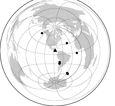
Azimuth Distribution of Events:
Prior Results for this Station
| Study | Thickness | Vp/Vs | Vp | Vs | Poissons Ratio | Extra |
| EARS | 32 km | 1.81 | 6.597 km/s | 3.64 km/s | 0.28 | |
| Crust2.0 | 40 km | 1.77 | 6.597 km/s | 3.723 km/s | 0.27 | L3,continental arc, Southern Andes, 0.2 km seds. |
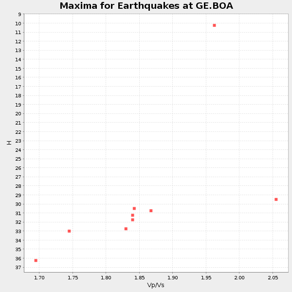
| Global Maxima | 32 km | 1.81 | 6.597 km/s | 3.64 km/s | 0.28 | amp=0.06493609 |
| Local Maxima 1 | 34 km | 1.74 | 6.597 km/s | 3.786 km/s | 0.25 | amp=0.035389967 |
| Local Maxima 2 | 30 km | 1.86 | 6.597 km/s | 3.552 km/s | 0.30 | amp=0.016680589 |
| Local Maxima 3 | 42 km | 1.63 | 6.597 km/s | 4.054 km/s | 0.20 | amp=0.013976185 |
| Local Maxima 4 | 49 km | 1.60 | 6.597 km/s | 4.123 km/s | 0.18 | amp=0.008723158 |
| Predicted Arrivals for vertical incidence (zero ray parameter) | |
| Ps | 3.88 SECOND |
| PpPs | 13.43 SECOND |
| PsPs/PpSs | 17.31 SECOND |
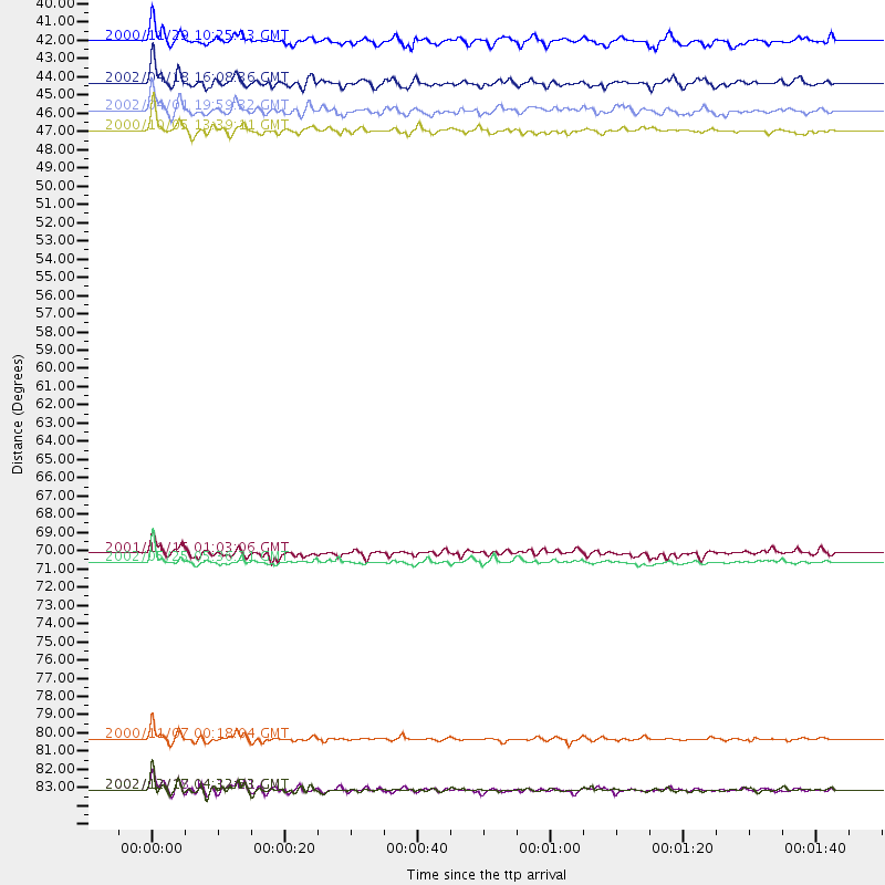
Events Processed for this Station
Download zip of receiver functions as SAC
Plot maxima for each earthquake.
Events Used in the Stack
(9 events)| Radial Match | Distance | Baz | FERegion | Time | Lat/Lon | Depth | Magnitude |
| 95.194786 | 82.2 deg | 151.747 deg | South Sandwich Islands Region | 2000/11/07 00:18:04 GMT | (-55.6, -29.9) | 10 km | 6.7 MS, 6.8 MW, 6.6 MW |
| 92.83557 | 42.4 deg | 159.945 deg | Near Coast Of Northern Chile | 2002/04/18 16:08:36 GMT | (-27.5, -70.6) | 62 km | 6.2 MB, 6.7 MW, 6.6 MW |
| 90.935814 | 71.5 deg | 322.744 deg | South Of Alaska | 2002/05/25 05:36:31 GMT | (53.8, -161.1) | 33 km | 5.5 MB, 6.1 MS, 6.5 MW, 6.4 MW |
| 90.431625 | 85.3 deg | 151.474 deg | South Sandwich Islands Region | 2002/12/18 14:12:21 GMT | (-57.1, -25.0) | 10 km | 5.5 MB, 6.0 MS, 6.2 MW, 5.9 MW |
| 89.941895 | 85.3 deg | 151.309 deg | South Sandwich Islands Region | 2002/12/17 04:32:53 GMT | (-57.0, -24.8) | 10 km | 5.4 MB, 6.3 MS, 6.2 MW, 6.0 MW |
| 85.12264 | 44.1 deg | 162.024 deg | Near Coast Of Central Chile | 2002/04/01 19:59:32 GMT | (-29.7, -71.4) | 71 km | 6.1 MB, 6.4 MW, 6.4 MW |
| 82.71631 | 39.8 deg | 158.775 deg | Near Coast Of Northern Chile | 2000/11/29 10:25:13 GMT | (-24.9, -70.9) | 58 km | 5.8 MB, 5.9 MS, 6.4 MW, 6.3 MW |
| 82.02459 | 70.9 deg | 96.061 deg | North Of Ascension Island | 2001/11/15 01:03:06 GMT | (-1.6, -15.6) | 10 km | 5.5 MB, 6.0 MS, 6.3 MW, 6.3 MW |
| 81.61249 | 45.3 deg | 57.524 deg | Northern Mid-Atlantic Ridge | 2000/10/05 13:39:11 GMT | (31.7, -41.0) | 10 km | 5.4 MB, 6.1 MS, 6.0 MW, 5.9 MW |
Losers
(0 events)| Radial Match | Distance | Baz | FERegion | Time | Lat/Lon | Depth | Magnitude | Reason |
