
Station GE NAI - IRIS/GEOFON Station Nairobi, Kenya
Network: GE - GEOFON
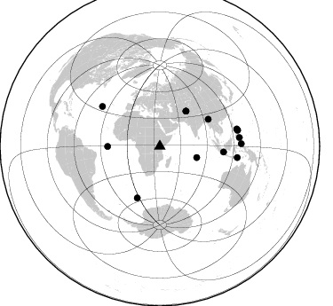
Nearby stations (2 deg radius)
| Station | Name | (Lat, Lon) | Start / End | Elevation |
| NAI | IRIS/GEOFON Station Nairobi, Kenya | (-1.27, 36.80) | 1995-01-05 / 1995-09-18 | 1692 m |
| Crust2 Type: | X5,thick Rift 0.25 km sediments |
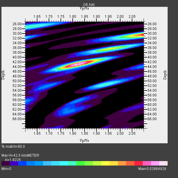
| Thickness Estimate: | 42 km |
| Thickness StdDev: | 4.5 km |
| Vp/Vs Estimate: | 1.82 |
| Vp/Vs StdDev: | 0.10 |
| Vs Estimate: | 3.622 km/s |
| Poisson's Ratio: | 0.28 |
| Peak Value: | 0.04 |
| Assumed Vp: | 6.601 km/s |
| Ps Weight: | 0.33333334 |
| PpPs Weight: | 0.33333334 |
| PsPs Weight: | 0.33333328 |
| Residual Complexity: | 0.647 |
| Nearby stations H: | 42 km +- 0.7 km |
| (2.0 deg) Vp/Vs: | 1.82 +- 0.01 |
8 with match > 90% ( 44.444443 %) and 14 with match > 80% ( 77.77778 %) out of 18.
Download stack as xyz text file.
Azimuth Distribution of Events:
Prior Results for this Station
| Study | Thickness | Vp/Vs | Vp | Vs | Poissons Ratio | Extra |
| EARS | 42 km | 1.82 | 6.601 km/s | 3.622 km/s | 0.28 | |
| Crust2.0 | 38 km | 1.77 | 6.601 km/s | 3.729 km/s | 0.27 | X5,thick Rift 0.25 km sediments |
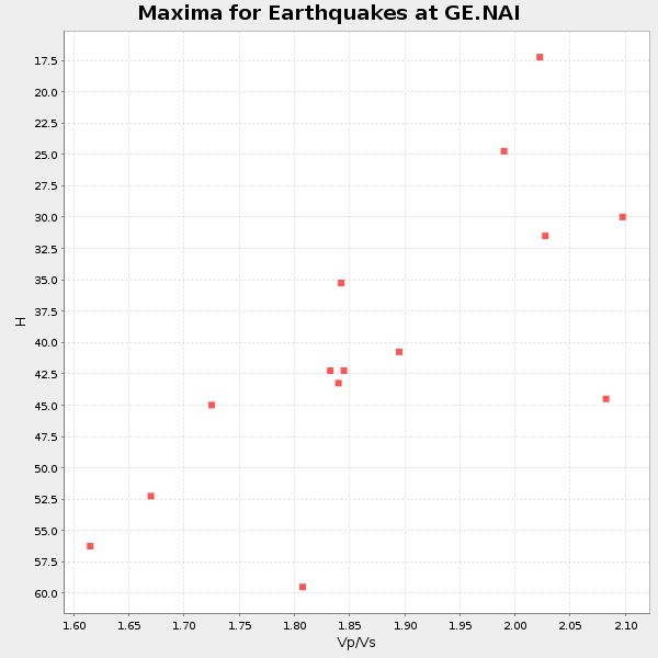
| Global Maxima | 42 km | 1.82 | 6.601 km/s | 3.622 km/s | 0.28 | amp=0.03864929 |
| Local Maxima 1 | 30 km | 2.10 | 6.601 km/s | 3.147 km/s | 0.35 | amp=0.03171634 |
| Local Maxima 2 | 27 km | 1.62 | 6.601 km/s | 4.074 km/s | 0.19 | amp=0.017257515 |
| Local Maxima 3 | 51 km | 1.94 | 6.601 km/s | 3.402 km/s | 0.32 | amp=0.016325038 |
| Local Maxima 4 | 36 km | 1.98 | 6.601 km/s | 3.329 km/s | 0.33 | amp=0.014039112 |
| Predicted Arrivals for vertical incidence (zero ray parameter) | |
| Ps | 5.30 SECOND |
| PpPs | 18.17 SECOND |
| PsPs/PpSs | 23.47 SECOND |
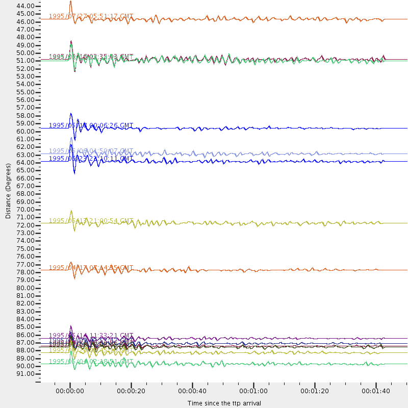
Events Processed for this Station
Download zip of receiver functions as SAC
Plot maxima for each earthquake.
Events Used in the Stack
(14 events)| Radial Match | Distance | Baz | FERegion | Time | Lat/Lon | Depth | Magnitude |
| 96.582985 | 88.8 deg | 77.427 deg | Samar, Philippines | 1995/05/05 03:53:47 GMT | (12.6, 125.3) | 33 km | 6.2 MB, 7.0 MS, 7.1 UNKNOWN, 7.0 MW |
| 96.5206 | 62.3 deg | 60.899 deg | Myanmar-India Border Region | 1995/05/06 01:59:07 GMT | (25.0, 95.3) | 122 km | 6.4 MB, 6.5 UNKNOWN, 6.4 MW |
| 94.855896 | 89.2 deg | 78.056 deg | Samar, Philippines | 1995/04/21 00:09:56 GMT | (12.0, 125.7) | 33 km | 6.1 MB, 6.9 MS, 6.9 UNKNOWN, 6.8 MW |
| 94.82453 | 63.4 deg | 203.731 deg | Southern Mid-Atlantic Ridge | 1995/05/23 22:10:11 GMT | (-56.1, -3.2) | 10 km | 5.3 MB, 6.6 MS, 6.8 UNKNOWN, 6.7 MW |
| 94.32168 | 90.2 deg | 83.756 deg | Mindanao, Philippines | 1995/04/20 08:45:10 GMT | (6.3, 126.8) | 85 km | 6.2 MB, 6.6 UNKNOWN, 6.5 MW |
| 94.22502 | 88.1 deg | 98.305 deg | Timor Region | 1995/05/14 11:33:21 GMT | (-8.4, 125.1) | 33 km | 6.1 MB, 6.9 MS, 7.1 UNKNOWN, 6.9 MW |
| 94.07957 | 58.8 deg | 269.663 deg | Central Mid-Atlantic Ridge | 1995/05/18 00:06:26 GMT | (-0.9, -22.0) | 10 km | 6.2 MB, 6.1 MS, 6.8 UNKNOWN, 6.7 MW |
| 90.450455 | 91.7 deg | 88.192 deg | Halmahera, Indonesia | 1995/05/04 02:18:51 GMT | (1.9, 128.5) | 55 km | 6.0 MB, 6.0 MS, 6.1 UNKNOWN, 6.1 MW |
| 87.156136 | 43.5 deg | 106.922 deg | South Indian Ocean | 1995/07/27 05:51:17 GMT | (-12.6, 79.2) | 10 km | 6.2 MB, 5.9 MS, 6.0 UNKNOWN, 6.0 MW |
| 85.689705 | 49.1 deg | 36.674 deg | Hindu Kush Region, Afghanistan | 1995/05/16 03:35:03 GMT | (36.5, 70.9) | 190 km | 5.7 MB, 5.9 UNKNOWN, 5.8 MW |
| 84.4529 | 78.6 deg | 304.689 deg | Northern Mid-Atlantic Ridge | 1995/04/17 07:14:35 GMT | (33.8, -38.6) | 10 km | 5.8 MB, 5.8 MS, 5.9 UNKNOWN, 6.1 MW |
| 83.892815 | 49.3 deg | 36.879 deg | Afghanistan-Tajikistan Bord Reg. | 1995/08/17 23:14:19 GMT | (36.5, 71.2) | 239 km | 5.7 UNKNOWN, 5.4 MB, 5.6 MW |
| 82.96096 | 89.4 deg | 78.491 deg | Samar, Philippines | 1995/05/08 18:08:09 GMT | (11.6, 125.9) | 33 km | 5.6 MB, 6.2 MS, 6.3 UNKNOWN, 6.3 MW |
| 82.674095 | 72.1 deg | 95.036 deg | Java Sea | 1995/05/13 21:00:54 GMT | (-5.2, 108.9) | 554 km | 5.7 MB, 5.9 UNKNOWN, 5.8 MW |
Losers
(4 events)| Radial Match | Distance | Baz | FERegion | Time | Lat/Lon | Depth | Magnitude | Reason |
| 96.064766 | 88.7 deg | 77.41 deg | Samar, Philippines | 1995/05/05 04:39:13 GMT | (12.6, 125.2) | 55 km | 5.6 MB, 6.5 UNKNOWN | |
| 89.25195 | 63.4 deg | 41.358 deg | Southern Xinjiang, China | 1995/08/17 00:59:57 GMT | (41.6, 88.8) | 0.0 km | 6.0 MB | |
| 59.847595 | 63.5 deg | 41.297 deg | Southern Xinjiang, China | 1995/05/15 04:05:58 GMT | (41.7, 88.8) | 0.0 km | 6.1 MB | |
| 41.00347 | 97.5 deg | 92.992 deg | Irian Jaya Region, Indonesia | 1995/03/13 10:31:50 GMT | (-2.8, 134.3) | 33 km | 5.5 MB, 5.7 MS, 5.6 UNKNOWN, 6.1 MW |
