
Station WI ANBD - Bethesda, Antigua
Network: WI - West Indies IPGP Network
Nearby stations (2 deg radius)
| Station | Name | (Lat, Lon) | Start / End | Elevation |
| ANBD | Bethesda, Antigua | (17.05, -61.76) | 2014-09-17 / 2599-12-31 | 26 m |
| Crust2 Type: | S2,continental slope, margin, transition 2 km seds. |
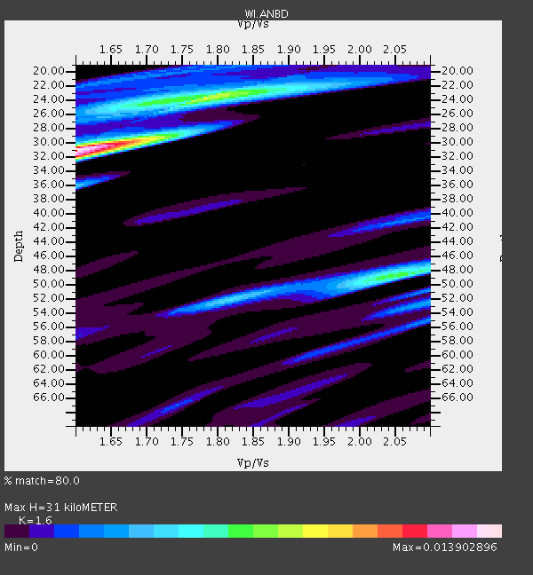
| Thickness Estimate: | 31 km |
| Thickness StdDev: | 11 km |
| Vp/Vs Estimate: | 1.60 |
| Vp/Vs StdDev: | 0.18 |
| Vs Estimate: | 3.78 km/s |
| Poisson's Ratio: | 0.18 |
| Peak Value: | 0.01 |
| Assumed Vp: | 6.048 km/s |
| Ps Weight: | 0.33333334 |
| PpPs Weight: | 0.33333334 |
| PsPs Weight: | 0.33333328 |
| Residual Complexity: | 0.746 |
| Nearby stations H: | +- |
| (2.0 deg) Vp/Vs: | +- |
2 with match > 90% ( 6.060606 %) and 7 with match > 80% ( 21.212122 %) out of 33.
Download stack as xyz text file.
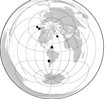
Azimuth Distribution of Events:
Prior Results for this Station
| Study | Thickness | Vp/Vs | Vp | Vs | Poissons Ratio | Extra |
| EARS | 31 km | 1.60 | 6.048 km/s | 3.78 km/s | 0.18 | |
| Crust2.0 | 24 km | 1.81 | 6.048 km/s | 3.34 km/s | 0.28 | S2,continental slope, margin, transition 2 km seds. |
| Global Maxima | 31 km | 1.60 | 6.048 km/s | 3.78 km/s | 0.18 | amp=0.013902896 |
| Local Maxima 1 | 24 km | 1.78 | 6.048 km/s | 3.398 km/s | 0.27 | amp=0.007998747 |
| Local Maxima 2 | 49 km | 2.04 | 6.048 km/s | 2.968 km/s | 0.34 | amp=0.0065698395 |
| Local Maxima 3 | 32 km | 1.60 | 6.048 km/s | 3.78 km/s | 0.18 | amp=0.003957623 |
| Local Maxima 4 | 36 km | 1.60 | 6.048 km/s | 3.78 km/s | 0.18 | amp=0.0034968357 |
| Predicted Arrivals for vertical incidence (zero ray parameter) | |
| Ps | 3.08 SECOND |
| PpPs | 13.33 SECOND |
| PsPs/PpSs | 16.40 SECOND |
Events Processed for this Station
Download zip of receiver functions as SAC
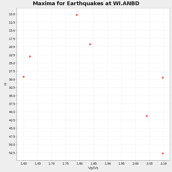
Plot maxima for each earthquake.
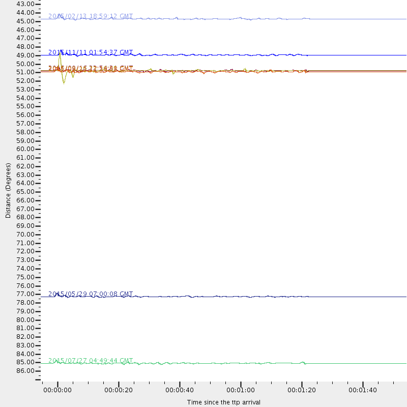
Events Used in the Stack
(7 events)| Radial Match | Distance | Baz | FERegion | Time | Lat/Lon | Depth | Magnitude |
| 93.83795 | 49.3 deg | 191.259 deg | Near Coast Of Central Chile | 2015/09/16 22:54:31 GMT | (-31.6, -71.8) | 12 km | 8.3 MWW, 7.9 MI |
| 90.37054 | 49.3 deg | 191.43 deg | Near Coast Of Central Chile | 2015/09/16 23:16:05 GMT | (-31.6, -71.9) | 10 km | 6.2 MB |
| 86.90956 | 78.5 deg | 325.873 deg | Alaska Peninsula | 2015/05/29 07:00:08 GMT | (56.7, -156.5) | 62 km | 6.8 MWP, 6.8 MI |
| 86.689476 | 87.1 deg | 324.259 deg | Fox Islands, Aleutian Islands | 2015/07/27 04:49:44 GMT | (52.4, -169.7) | 12 km | 6.9 MO |
| 82.57051 | 47.3 deg | 192.305 deg | Off Coast Of Central Chile | 2015/11/11 01:54:37 GMT | (-29.4, -72.1) | 10 km | 6.9 MWW, 6.6 MI |
| 81.148895 | 49.4 deg | 191.085 deg | Near Coast Of Central Chile | 2015/09/21 17:39:58 GMT | (-31.7, -71.6) | 25 km | 6.5 MB, 6.5 MI, 6.6 MWW |
| 80.24654 | 42.6 deg | 26.672 deg | Northern Mid-Atlantic Ridge | 2015/02/13 18:59:12 GMT | (52.6, -31.9) | 16 km | 7.1 MWW, 6.8 MI, 7.0 MWB, 7.0 MWC, 7.1 MWC |
Losers
(26 events)| Radial Match | Distance | Baz | FERegion | Time | Lat/Lon | Depth | Magnitude | Reason |
| 81.44523 | 30.4 deg | 272.457 deg | Near Coast Of Chiapas, Mexico | 2015/12/17 19:49:54 GMT | (15.9, -93.4) | 97 km | 6.4 MWB, 6.6 MI | |
| 79.71684 | 50.2 deg | 191.543 deg | Off Coast Of Central Chile | 2015/09/18 09:10:44 GMT | (-32.4, -72.2) | 8.7 km | 6.3 MWP | |
| 78.62334 | 42.6 deg | 26.569 deg | Northern Mid-Atlantic Ridge | 2015/02/13 19:47:42 GMT | (52.7, -31.9) | 13 km | 4.8 mb | |
| 76.587555 | 48.9 deg | 191.408 deg | Near Coast Of Central Chile | 2015/09/16 23:23:26 GMT | (-31.2, -71.8) | 37 km | 5.6 MB | |
| 75.08021 | 50.1 deg | 191.411 deg | Off Coast Of Central Chile | 2015/09/19 12:52:19 GMT | (-32.3, -72.1) | 11 km | 6.2 MWB | |
| 73.3404 | 49.2 deg | 191.192 deg | Near Coast Of Central Chile | 2015/09/16 23:09:22 GMT | (-31.5, -71.7) | 10 km | 5.6 MB, 5.9 MB | |
| 71.056206 | 30.9 deg | 216.693 deg | Near Coast Of Northern Peru | 2015/04/26 23:35:29 GMT | (-8.3, -79.8) | 22 km | 5.6 MWW, 5.6 MWB, 5.7 MWC | |
| 70.20396 | 48.5 deg | 191.07 deg | Near Coast Of Central Chile | 2015/09/26 02:51:18 GMT | (-30.8, -71.4) | 38 km | 6.2 MO | |
| 70.134674 | 49.3 deg | 191.214 deg | Near Coast Of Central Chile | 2015/09/21 05:39:33 GMT | (-31.6, -71.7) | 23 km | 6.3 MWP | |
| 68.59198 | 40.2 deg | 187.036 deg | Jujuy Province, Argentina | 2015/02/11 18:57:22 GMT | (-23.1, -66.7) | 223 km | 6.7 MWW, 6.7 MWC, 6.7 MWB, 6.9 MI | |
| 68.13157 | 48.6 deg | 191.223 deg | Near Coast Of Central Chile | 2015/11/07 07:31:42 GMT | (-30.9, -71.5) | 36 km | 6.8 MWP, 6.8 MI | |
| 66.003006 | 77.7 deg | 161.25 deg | South Sandwich Islands Region | 2015/02/16 22:00:53 GMT | (-55.5, -28.2) | 10 km | 6.2 MWW, 6.7 MI | |
| 65.505325 | 47.5 deg | 192.255 deg | Off Coast Of Central Chile | 2015/09/19 05:06:47 GMT | (-29.7, -72.1) | 10 km | 5.8 MWR | |
| 64.86857 | 54.0 deg | 191.869 deg | Near Coast Of Central Chile | 2015/03/18 18:27:28 GMT | (-36.1, -73.6) | 10 km | 6.2 MWB, 6.2 MWW | |
| 64.81068 | 63.4 deg | 318.606 deg | Vancouver Island, Canada Region | 2015/09/24 13:48:58 GMT | (50.7, -130.2) | 10 km | 5.5 MB, 5.6 MI | |
| 61.19304 | 80.0 deg | 161.285 deg | South Sandwich Islands Region | 2015/08/26 13:51:39 GMT | (-57.5, -26.0) | 64 km | 5.7 MB | |
| 60.374653 | 54.3 deg | 191.984 deg | Near Coast Of Central Chile | 2015/06/20 02:10:06 GMT | (-36.3, -73.8) | 10 km | 6.4 MO | |
| 60.242138 | 48.8 deg | 191.24 deg | Near Coast Of Central Chile | 2015/09/19 09:07:08 GMT | (-31.1, -71.6) | 23 km | 6.1 MWP | |
| 58.072136 | 48.8 deg | 191.468 deg | Near Coast Of Central Chile | 2015/09/21 15:37:08 GMT | (-31.0, -71.8) | 26 km | 5.4 mww | |
| 56.80718 | 49.1 deg | 190.676 deg | Near Coast Of Central Chile | 2015/09/22 07:12:59 GMT | (-31.5, -71.2) | 54 km | 6.1 MWB | |
| 54.28912 | 46.7 deg | 183.264 deg | Santiago Del Estero Prov., Arg. | 2015/11/13 06:04:15 GMT | (-29.9, -64.5) | 11 km | 5.8 MWP | |
| 53.784153 | 48.4 deg | 192.022 deg | Off Coast Of Central Chile | 2015/09/19 13:08:57 GMT | (-30.6, -72.2) | 14 km | 5.6 MB | |
| 52.957024 | 89.5 deg | 324.618 deg | Andreanof Islands, Aleutian Is. | 2015/11/02 08:15:34 GMT | (51.7, -173.4) | 21 km | 5.9 MWP, 5.2 MI | |
| 43.79274 | 90.5 deg | 325.14 deg | Andreanof Islands, Aleutian Is. | 2015/08/15 20:16:21 GMT | (51.7, -175.2) | 32 km | 5.6 MWB, 5.5 MI, 5.6 ML, 5.6 MWC | |
| 43.512142 | 48.8 deg | 190.938 deg | Near Coast Of Central Chile | 2015/09/16 23:09:05 GMT | (-31.1, -71.3) | 26 km | 5.6 MB | |
| 42.384308 | 51.6 deg | 313.653 deg | Western Idaho | 2015/01/03 17:44:03 GMT | (44.5, -114.1) | 12 km | 5.0 MW, 4.3 MS, 5.0 mb |

