
Station XA SA18 - XA.SA18
Network: XA97 - Anatomy of an Archean Craton, South Africa
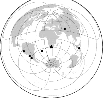
Nearby stations (2 deg radius)
| Station | Name | (Lat, Lon) | Start / End | Elevation |
| SA18 | XA.SA18 | (-28.63, 24.31) | 1997-04-14 / 1999-12-31 | 1102 m |
| Crust2 Type: | G1,Archean, no seds. |
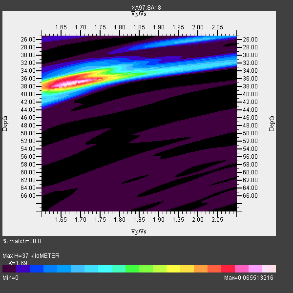
| Thickness Estimate: | 37 km |
| Thickness StdDev: | 0.5 km |
| Vp/Vs Estimate: | 1.69 |
| Vp/Vs StdDev: | 0.02 |
| Vs Estimate: | 3.822 km/s |
| Poisson's Ratio: | 0.23 |
| Peak Value: | 0.07 |
| Assumed Vp: | 6.459 km/s |
| Ps Weight: | 0.33333334 |
| PpPs Weight: | 0.33333334 |
| PsPs Weight: | 0.33333328 |
| Residual Complexity: | 0.494 |
| Nearby stations H: | +- |
| (2.0 deg) Vp/Vs: | +- |
4 with match > 90% ( 19.047619 %) and 7 with match > 80% ( 33.333332 %) out of 21.
Download stack as xyz text file.
Azimuth Distribution of Events:
Prior Results for this Station
| Study | Thickness | Vp/Vs | Vp | Vs | Poissons Ratio | Extra |
| EARS | 37 km | 1.69 | 6.459 km/s | 3.822 km/s | 0.23 | |
| Crust2.0 | 37 km | 1.76 | 6.459 km/s | 3.665 km/s | 0.26 | G1,Archean, no seds. |
| Global Maxima | 37 km | 1.69 | 6.459 km/s | 3.822 km/s | 0.23 | amp=0.065513216 |
| Local Maxima 1 | 36 km | 1.67 | 6.459 km/s | 3.874 km/s | 0.22 | amp=0.042892605 |
| Local Maxima 2 | 26 km | 2.00 | 6.459 km/s | 3.238 km/s | 0.33 | amp=0.015123839 |
| Local Maxima 3 | 38 km | 1.72 | 6.459 km/s | 3.766 km/s | 0.24 | amp=0.010851526 |
| Local Maxima 4 | 34 km | 1.91 | 6.459 km/s | 3.386 km/s | 0.31 | amp=0.009502493 |
| Predicted Arrivals for vertical incidence (zero ray parameter) | |
| Ps | 3.95 SECOND |
| PpPs | 15.41 SECOND |
| PsPs/PpSs | 19.36 SECOND |
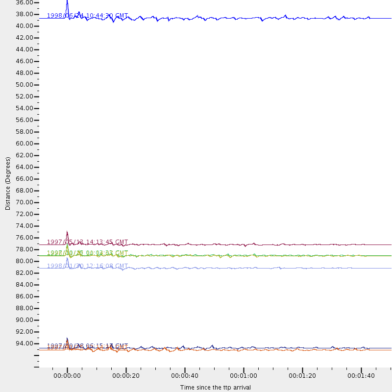
Events Processed for this Station
Download zip of receiver functions as SAC
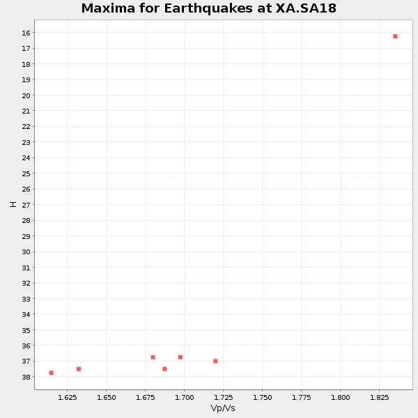
Plot maxima for each earthquake.
Events Used in the Stack
(7 events)| Radial Match | Distance | Baz | FERegion | Time | Lat/Lon | Depth | Magnitude |
| 98.76245 | 80.1 deg | 240.238 deg | Near Coast Of Central Chile | 1997/10/15 01:03:33 GMT | (-30.9, -71.2) | 58 km | 6.8 MB, 6.8 MS, 7.3 UNKNOWN, 7.1 MW |
| 96.48317 | 82.6 deg | 246.926 deg | Near Coast Of Northern Chile | 1998/01/30 12:16:08 GMT | (-23.9, -70.2) | 42 km | 6.3 MB, 6.5 MS, 7.0 UNKNOWN, 6.7 ME |
| 92.72156 | 80.3 deg | 240.115 deg | Near Coast Of Central Chile | 1998/01/12 10:14:07 GMT | (-31.0, -71.4) | 35 km | 5.8 MB, 6.2 MS, 6.6 UNKNOWN, 6.2 ME |
| 91.60747 | 78.2 deg | 36.815 deg | Hindu Kush Region, Afghanistan | 1997/05/13 14:13:45 GMT | (36.4, 70.9) | 196 km | 6.1 MB, 6.5 UNKNOWN, 6.4 MW |
| 87.327644 | 97.5 deg | 260.882 deg | Northern Peru | 1997/10/28 06:15:17 GMT | (-4.4, -76.7) | 112 km | 6.6 MB, 6.3 MS, 7.2 UNKNOWN, 6.6 ME |
| 83.36399 | 35.8 deg | 245.076 deg | Southern Mid-Atlantic Ridge | 1998/06/24 10:44:30 GMT | (-37.3, -17.4) | 10 km | 5.7 MB, 5.8 MS, 6.0 UNKNOWN, 5.9 MW |
| 82.30404 | 97.8 deg | 92.853 deg | Minahassa Peninsula, Sulawesi | 1997/11/25 12:14:33 GMT | (1.2, 122.5) | 24 km | 6.1 MB, 6.8 MS, 7.1 UNKNOWN, 6.7 ME |
Losers
(14 events)| Radial Match | Distance | Baz | FERegion | Time | Lat/Lon | Depth | Magnitude | Reason |
| 79.40629 | 81.1 deg | 240.757 deg | Near Coast Of Central Chile | 1997/07/06 09:54:00 GMT | (-30.1, -71.9) | 19 km | 5.8 MB, 6.5 MS, 6.8 UNKNOWN, 6.4 ME | |
| 79.1683 | 84.5 deg | 96.28 deg | Java, Indonesia | 1998/09/28 13:34:30 GMT | (-8.2, 112.4) | 152 km | 6.4 MB, 6.5 UNKNOWN, 6.5 MW | |
| 73.526794 | 32.9 deg | 223.822 deg | Southern Mid-Atlantic Ridge | 1997/04/25 09:11:34 GMT | (-48.3, -10.0) | 10 km | 5.8 MS, 5.3 MB, 5.8 UNKNOWN, 5.7 MW | |
| 71.528175 | 34.8 deg | 248.202 deg | Southern Mid-Atlantic Ridge | 1998/01/03 06:10:08 GMT | (-35.5, -16.2) | 10 km | 5.9 MS, 5.4 MB, 6.3 UNKNOWN, 6.1 MW | |
| 67.171776 | 41.6 deg | 78.108 deg | Mid-Indian Ridge | 1997/09/25 14:20:48 GMT | (-13.8, 66.2) | 10 km | 5.3 MB, 5.7 MS, 6.0 UNKNOWN, 6.0 MW | |
| 66.386215 | 47.5 deg | 213.533 deg | South Sandwich Islands Region | 1997/10/05 18:04:30 GMT | (-59.7, -29.2) | 274 km | 6.0 MB, 6.3 UNKNOWN, 6.3 MW | |
| 61.794155 | 80.5 deg | 244.326 deg | Northern Chile | 1997/05/17 02:10:18 GMT | (-27.2, -69.5) | 106 km | 5.5 MB, 5.6 UNKNOWN, 5.5 MW | |
| 59.730953 | 86.2 deg | 256.527 deg | Peru-Bolivia Border Region | 1997/11/28 22:53:41 GMT | (-13.7, -68.8) | 586 km | 6.4 MB, 6.6 UNKNOWN, 6.6 MW | |
| 58.882538 | 87.8 deg | 59.587 deg | Myanmar | 1997/12/30 13:43:18 GMT | (25.4, 96.6) | 33 km | 5.7 MS, 5.4 MB, 5.7 UNKNOWN, 5.7 MW | |
| 58.81685 | 81.3 deg | 241.528 deg | Near Coast Of Central Chile | 1997/07/19 12:22:57 GMT | (-29.3, -71.7) | 26 km | 5.8 MB, 5.5 MS, 5.9 UNKNOWN, 5.8 MW | |
| 58.393185 | 79.8 deg | 249.425 deg | Jujuy Province, Argentina | 1997/07/20 10:14:22 GMT | (-23.0, -66.3) | 256 km | 5.7 MB, 6.1 UNKNOWN, 5.7 ME | |
| 57.111534 | 81.9 deg | 249.024 deg | Northern Chile | 1997/09/28 23:13:13 GMT | (-22.4, -68.4) | 107 km | 5.7 MB, 5.6 UNKNOWN, 5.6 MW | |
| 56.998447 | 84.2 deg | 93.321 deg | Java Sea | 1997/07/11 09:55:12 GMT | (-5.7, 110.8) | 574 km | 5.6 MB | |
| 53.363773 | 82.8 deg | 250.992 deg | Chile-Bolivia Border Region | 1997/12/09 14:23:45 GMT | (-20.2, -68.4) | 133 km | 5.7 MB, 5.7 UNKNOWN, 5.7 MW |
