
Station XA SA30 - XA.SA30
Network: XA97 - Anatomy of an Archean Craton, South Africa
Nearby stations (2 deg radius)
| Station | Name | (Lat, Lon) | Start / End | Elevation |
| SA30 | XA.SA30 | (-27.07, 24.17) | 1997-04-22 / 1999-12-31 | 1361 m |
| Crust2 Type: | G1,Archean, no seds. |
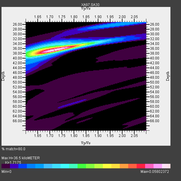
| Thickness Estimate: | 36 km |
| Thickness StdDev: | 0.3 km |
| Vp/Vs Estimate: | 1.72 |
| Vp/Vs StdDev: | 0.02 |
| Vs Estimate: | 3.761 km/s |
| Poisson's Ratio: | 0.24 |
| Peak Value: | 0.06 |
| Assumed Vp: | 6.459 km/s |
| Ps Weight: | 0.33333334 |
| PpPs Weight: | 0.33333334 |
| PsPs Weight: | 0.33333328 |
| Residual Complexity: | 0.367 |
| Nearby stations H: | +- |
| (2.0 deg) Vp/Vs: | +- |
6 with match > 90% ( 21.428572 %) and 10 with match > 80% ( 35.714287 %) out of 28.
Download stack as xyz text file.
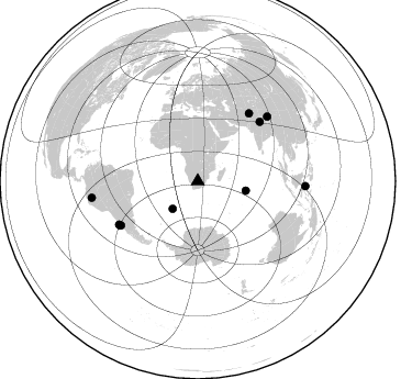
Azimuth Distribution of Events:
Prior Results for this Station
| Study | Thickness | Vp/Vs | Vp | Vs | Poissons Ratio | Extra |
| EARS | 36 km | 1.72 | 6.459 km/s | 3.761 km/s | 0.24 | |
| Crust2.0 | 37 km | 1.76 | 6.459 km/s | 3.665 km/s | 0.26 | G1,Archean, no seds. |
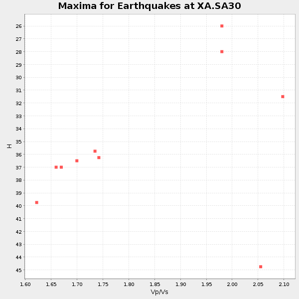
| Global Maxima | 36 km | 1.72 | 6.459 km/s | 3.761 km/s | 0.24 | amp=0.05802372 |
| Local Maxima 1 | 36 km | 1.66 | 6.459 km/s | 3.897 km/s | 0.21 | amp=0.021465903 |
| Local Maxima 2 | 26 km | 1.97 | 6.459 km/s | 3.275 km/s | 0.33 | amp=0.011974314 |
| Local Maxima 3 | 34 km | 1.84 | 6.459 km/s | 3.506 km/s | 0.29 | amp=0.00951096 |
| Local Maxima 4 | 39 km | 1.65 | 6.459 km/s | 3.921 km/s | 0.21 | amp=0.008419982 |
| Predicted Arrivals for vertical incidence (zero ray parameter) | |
| Ps | 4.05 SECOND |
| PpPs | 15.36 SECOND |
| PsPs/PpSs | 19.41 SECOND |
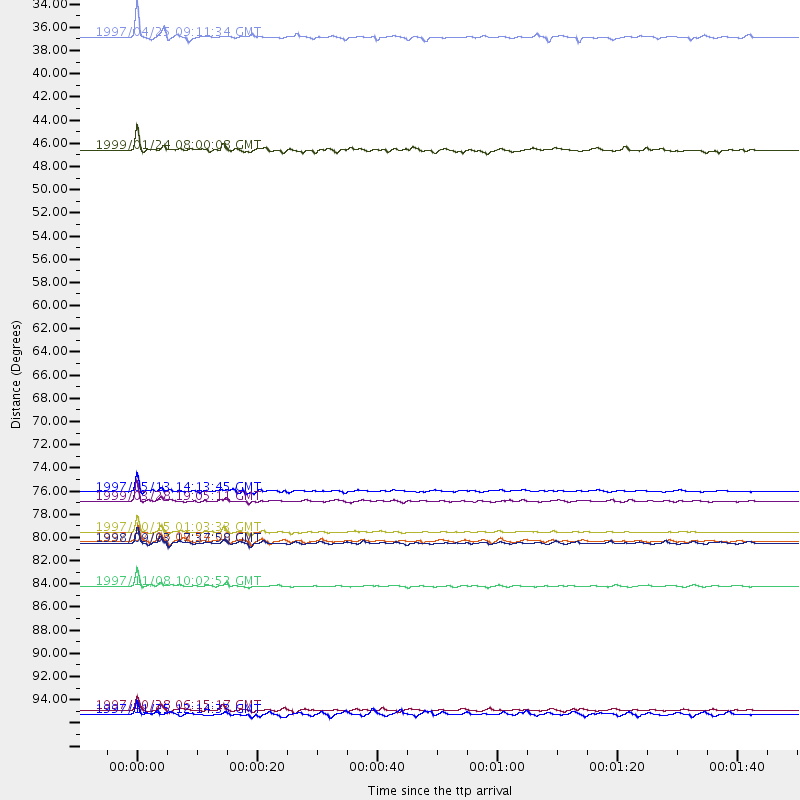
Events Processed for this Station
Download zip of receiver functions as SAC
Plot maxima for each earthquake.
Events Used in the Stack
(10 events)| Radial Match | Distance | Baz | FERegion | Time | Lat/Lon | Depth | Magnitude |
| 98.03632 | 80.8 deg | 240.067 deg | Near Coast Of Central Chile | 1997/10/15 01:03:33 GMT | (-30.9, -71.2) | 58 km | 6.8 MB, 6.8 MS, 7.3 UNKNOWN, 7.1 MW |
| 96.11992 | 85.9 deg | 47.203 deg | Xizang | 1997/11/08 10:02:52 GMT | (35.1, 87.3) | 33 km | 6.2 MB, 7.9 MS, 7.7 UNKNOWN, 7.6 MW |
| 93.48003 | 77.9 deg | 46.483 deg | Western Xizang-India Border Reg. | 1999/03/28 19:05:11 GMT | (30.5, 79.4) | 15 km | 6.4 MB, 6.6 MS, 6.6 MW, 6.5 ME |
| 93.2031 | 97.6 deg | 261.155 deg | Northern Peru | 1997/10/28 06:15:17 GMT | (-4.4, -76.7) | 112 km | 6.6 MB, 6.3 MS, 7.2 UNKNOWN, 6.6 ME |
| 92.68848 | 81.9 deg | 241.218 deg | Near Coast Of Central Chile | 1998/09/03 17:37:58 GMT | (-29.5, -71.7) | 27 km | 6.2 MB, 6.6 MS, 6.5 UNKNOWN, 6.4 ME |
| 91.58668 | 77.0 deg | 37.108 deg | Hindu Kush Region, Afghanistan | 1997/05/13 14:13:45 GMT | (36.4, 70.9) | 196 km | 6.1 MB, 6.5 UNKNOWN, 6.4 MW |
| 86.784485 | 44.7 deg | 101.158 deg | Mid-Indian Ridge | 1999/01/24 08:00:08 GMT | (-26.5, 74.5) | 10 km | 6.0 MB, 6.3 MS, 6.3 MW, 6.3 ME |
| 83.72736 | 81.7 deg | 240.608 deg | Near Coast Of Central Chile | 1997/07/06 09:54:00 GMT | (-30.1, -71.9) | 19 km | 5.8 MB, 6.5 MS, 6.8 UNKNOWN, 6.4 ME |
| 83.149704 | 98.0 deg | 92.703 deg | Minahassa Peninsula, Sulawesi | 1997/11/25 12:14:33 GMT | (1.2, 122.5) | 24 km | 6.1 MB, 6.8 MS, 7.1 UNKNOWN, 6.7 ME |
| 81.758934 | 34.0 deg | 222.145 deg | Southern Mid-Atlantic Ridge | 1997/04/25 09:11:34 GMT | (-48.3, -10.0) | 10 km | 5.8 MS, 5.3 MB, 5.8 UNKNOWN, 5.7 MW |
Losers
(18 events)| Radial Match | Distance | Baz | FERegion | Time | Lat/Lon | Depth | Magnitude | Reason |
| 77.81197 | 81.9 deg | 241.382 deg | Near Coast Of Central Chile | 1997/07/19 12:22:57 GMT | (-29.3, -71.7) | 26 km | 5.8 MB, 5.5 MS, 5.9 UNKNOWN, 5.8 MW | |
| 74.79955 | 46.4 deg | 217.478 deg | South Sandwich Islands Region | 1998/08/29 08:30:21 GMT | (-55.7, -27.0) | 33 km | 5.6 MB, 5.6 MS, 6.0 UNKNOWN, 5.9 MW | |
| 74.47018 | 35.3 deg | 246.155 deg | Southern Mid-Atlantic Ridge | 1998/01/03 06:10:08 GMT | (-35.5, -16.2) | 10 km | 5.9 MS, 5.4 MB, 6.3 UNKNOWN, 6.1 MW | |
| 71.08729 | 82.2 deg | 248.58 deg | Northern Chile | 1999/03/02 17:45:55 GMT | (-22.7, -68.5) | 111 km | 5.8 MB, 6.1 MW, 5.9 MW | |
| 70.98427 | 81.1 deg | 244.156 deg | Northern Chile | 1997/05/17 02:10:18 GMT | (-27.2, -69.5) | 106 km | 5.5 MB, 5.6 UNKNOWN, 5.5 MW | |
| 67.02595 | 41.4 deg | 79.927 deg | Mid-Indian Ridge | 1997/09/25 14:20:48 GMT | (-13.8, 66.2) | 10 km | 5.3 MB, 5.7 MS, 6.0 UNKNOWN, 6.0 MW | |
| 64.2543 | 86.4 deg | 256.493 deg | Peru-Bolivia Border Region | 1997/11/28 22:53:41 GMT | (-13.7, -68.8) | 586 km | 6.4 MB, 6.6 UNKNOWN, 6.6 MW | |
| 60.386116 | 87.6 deg | 253.232 deg | Southern Peru | 1998/10/08 04:51:42 GMT | (-16.1, -71.4) | 136 km | 6.1 MB, 6.4 UNKNOWN, 6.2 MW | |
| 55.545418 | 80.3 deg | 249.227 deg | Jujuy Province, Argentina | 1997/07/20 10:14:22 GMT | (-23.0, -66.3) | 256 km | 5.7 MB, 6.1 UNKNOWN, 5.7 ME | |
| 55.47229 | 69.4 deg | 31.223 deg | Northern And Central Iran | 1997/05/10 07:57:29 GMT | (33.8, 59.8) | 10 km | 6.4 MB, 7.3 MS, 7.5 UNKNOWN, 7.2 MW | |
| 55.18119 | 94.9 deg | 92.934 deg | Minahassa Peninsula, Sulawesi | 1998/10/10 16:32:19 GMT | (-0.4, 119.8) | 33 km | 5.7 MB, 5.6 MS, 6.0 UNKNOWN, 6.0 MW | |
| 54.85143 | 75.2 deg | 77.547 deg | Northern Sumatra, Indonesia | 1999/02/04 19:28:00 GMT | (4.0, 95.3) | 56 km | 5.8 MB, 5.4 MS, 5.9 MW, 5.9 MW | |
| 50.986862 | 91.6 deg | 108.747 deg | Western Australia | 1997/08/10 09:20:30 GMT | (-16.0, 124.3) | 10 km | 5.9 MB, 6.0 MS, 6.3 UNKNOWN, 6.3 MW | |
| 50.68151 | 77.6 deg | 233.447 deg | S. Chile-Argentina Border Region | 1998/12/14 16:25:24 GMT | (-38.2, -71.0) | 138 km | 6.0 UNKNOWN, 4.8 MS, 5.4 MB | |
| 48.40281 | 83.2 deg | 250.872 deg | Chile-Bolivia Border Region | 1997/12/09 14:23:45 GMT | (-20.2, -68.4) | 133 km | 5.7 MB, 5.7 UNKNOWN, 5.7 MW | |
| 44.358383 | 82.3 deg | 248.882 deg | Northern Chile | 1997/09/28 23:13:13 GMT | (-22.4, -68.4) | 107 km | 5.7 MB, 5.6 UNKNOWN, 5.6 MW | |
| 43.120186 | 84.8 deg | 96.489 deg | Java, Indonesia | 1998/09/28 13:34:30 GMT | (-8.2, 112.4) | 152 km | 6.4 MB, 6.5 UNKNOWN, 6.5 MW | |
| 40.333904 | 84.4 deg | 93.54 deg | Java Sea | 1997/07/11 09:55:12 GMT | (-5.7, 110.8) | 574 km | 5.6 MB |
