
Station XA SA38 - XA.SA38
Network: XA97 - Anatomy of an Archean Craton, South Africa
Nearby stations (2 deg radius)
| Station | Name | (Lat, Lon) | Start / End | Elevation |
| SA38 | XA.SA38 | (-25.93, 25.08) | 1997-04-22 / 1999-12-31 | 1219 m |
| Crust2 Type: | G1,Archean, no seds. |
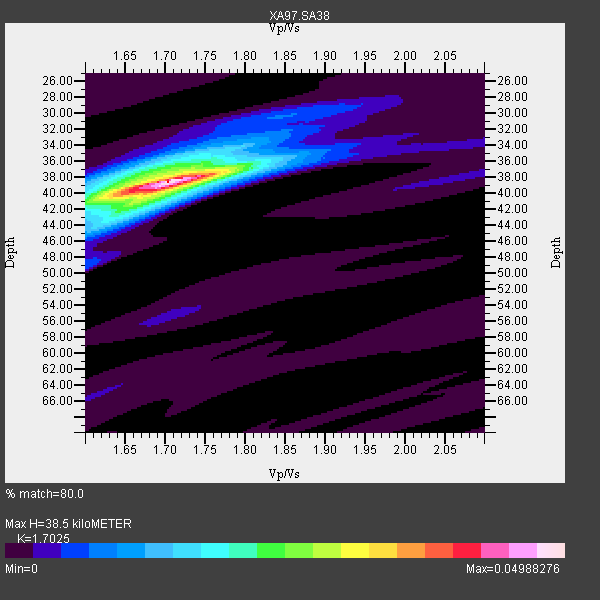
| Thickness Estimate: | 38 km |
| Thickness StdDev: | 0.4 km |
| Vp/Vs Estimate: | 1.70 |
| Vp/Vs StdDev: | 0.01 |
| Vs Estimate: | 3.794 km/s |
| Poisson's Ratio: | 0.24 |
| Peak Value: | 0.05 |
| Assumed Vp: | 6.459 km/s |
| Ps Weight: | 0.33333334 |
| PpPs Weight: | 0.33333334 |
| PsPs Weight: | 0.33333328 |
| Residual Complexity: | 0.364 |
| Nearby stations H: | +- |
| (2.0 deg) Vp/Vs: | +- |
5 with match > 90% ( 15.151515 %) and 13 with match > 80% ( 39.39394 %) out of 33.
Download stack as xyz text file.
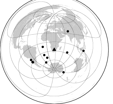
Azimuth Distribution of Events:
Prior Results for this Station
| Study | Thickness | Vp/Vs | Vp | Vs | Poissons Ratio | Extra |
| EARS | 38 km | 1.70 | 6.459 km/s | 3.794 km/s | 0.24 | |
| Crust2.0 | 37 km | 1.76 | 6.459 km/s | 3.665 km/s | 0.26 | G1,Archean, no seds. |
| Global Maxima | 38 km | 1.70 | 6.459 km/s | 3.794 km/s | 0.24 | amp=0.04988276 |
| Local Maxima 1 | 41 km | 1.65 | 6.459 km/s | 3.903 km/s | 0.21 | amp=0.01752666 |
| Local Maxima 2 | 36 km | 1.74 | 6.459 km/s | 3.712 km/s | 0.25 | amp=0.015135823 |
| Local Maxima 3 | 37 km | 1.67 | 6.459 km/s | 3.862 km/s | 0.22 | amp=0.0072135064 |
| Local Maxima 4 | 49 km | 1.60 | 6.459 km/s | 4.037 km/s | 0.18 | amp=0.0061067888 |
| Predicted Arrivals for vertical incidence (zero ray parameter) | |
| Ps | 4.19 SECOND |
| PpPs | 16.11 SECOND |
| PsPs/PpSs | 20.29 SECOND |
Events Processed for this Station
Download zip of receiver functions as SAC
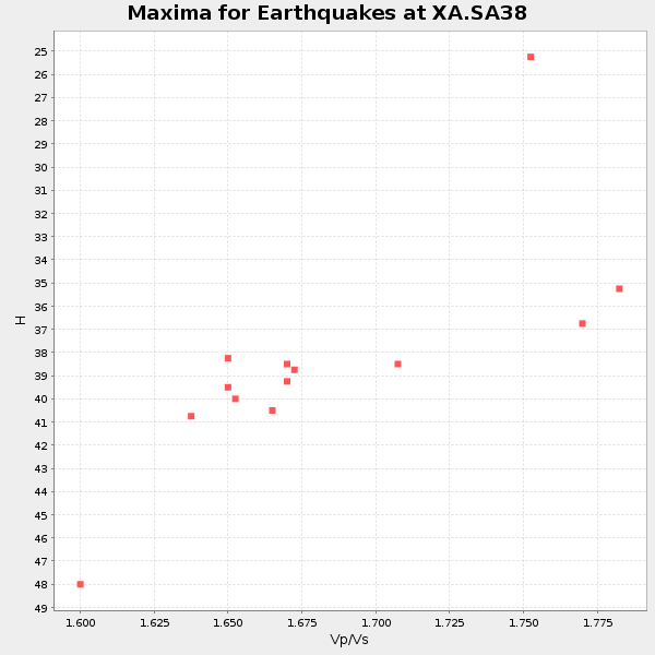
Plot maxima for each earthquake.
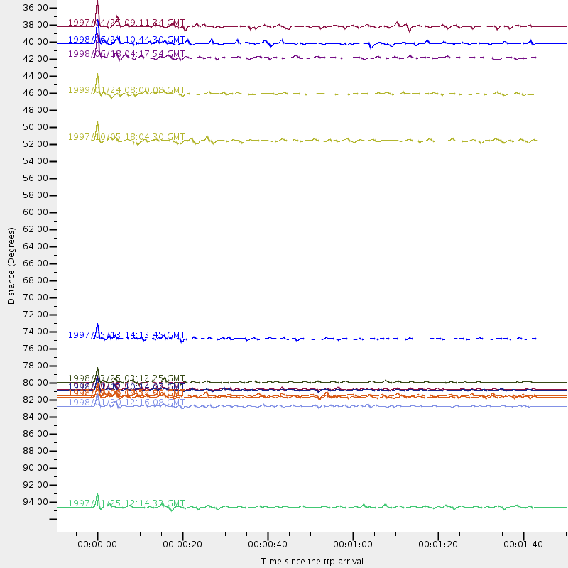
Events Used in the Stack
(13 events)| Radial Match | Distance | Baz | FERegion | Time | Lat/Lon | Depth | Magnitude |
| 98.240715 | 81.2 deg | 157.512 deg | Balleny Islands Region | 1998/03/25 03:12:25 GMT | (-62.9, 149.5) | 10 km | 6.6 MB, 8.0 MS, 8.3 UNKNOWN, 8.1 MW |
| 98.08099 | 82.1 deg | 239.573 deg | Near Coast Of Central Chile | 1997/10/15 01:03:33 GMT | (-30.9, -71.2) | 58 km | 6.8 MB, 6.8 MS, 7.3 UNKNOWN, 7.1 MW |
| 95.42033 | 84.3 deg | 246.319 deg | Near Coast Of Northern Chile | 1998/01/30 12:16:08 GMT | (-23.9, -70.2) | 42 km | 6.3 MB, 6.5 MS, 7.0 UNKNOWN, 6.7 ME |
| 92.43213 | 82.2 deg | 239.456 deg | Near Coast Of Central Chile | 1998/01/12 10:14:07 GMT | (-31.0, -71.4) | 35 km | 5.8 MB, 6.2 MS, 6.6 UNKNOWN, 6.2 ME |
| 91.853615 | 75.6 deg | 36.706 deg | Hindu Kush Region, Afghanistan | 1997/05/13 14:13:45 GMT | (36.4, 70.9) | 196 km | 6.1 MB, 6.5 UNKNOWN, 6.4 MW |
| 88.097244 | 83.1 deg | 240.732 deg | Near Coast Of Central Chile | 1998/09/03 17:37:58 GMT | (-29.5, -71.7) | 27 km | 6.2 MB, 6.6 MS, 6.5 UNKNOWN, 6.4 ME |
| 86.55438 | 50.1 deg | 212.405 deg | South Sandwich Islands Region | 1997/10/05 18:04:30 GMT | (-59.7, -29.2) | 274 km | 6.0 MB, 6.3 UNKNOWN, 6.3 MW |
| 86.32332 | 35.4 deg | 221.531 deg | Southern Mid-Atlantic Ridge | 1997/04/25 09:11:34 GMT | (-48.3, -10.0) | 10 km | 5.8 MS, 5.3 MB, 5.8 UNKNOWN, 5.7 MW |
| 86.07534 | 97.2 deg | 92.139 deg | Minahassa Peninsula, Sulawesi | 1997/11/25 12:14:33 GMT | (1.2, 122.5) | 24 km | 6.1 MB, 6.8 MS, 7.1 UNKNOWN, 6.7 ME |
| 85.85234 | 44.1 deg | 102.054 deg | Mid-Indian Ridge | 1999/01/24 08:00:08 GMT | (-26.5, 74.5) | 10 km | 6.0 MB, 6.3 MS, 6.3 MW, 6.3 ME |
| 85.29196 | 39.4 deg | 283.841 deg | Ascension Island Region | 1998/06/18 04:17:54 GMT | (-11.6, -13.9) | 10 km | 6.1 MS, 5.4 MB, 6.2 UNKNOWN |
| 84.85711 | 37.6 deg | 241.908 deg | Southern Mid-Atlantic Ridge | 1998/06/24 10:44:30 GMT | (-37.3, -17.4) | 10 km | 5.7 MB, 5.8 MS, 6.0 UNKNOWN, 5.9 MW |
| 80.52419 | 83.0 deg | 240.122 deg | Near Coast Of Central Chile | 1997/07/06 09:54:00 GMT | (-30.1, -71.9) | 19 km | 5.8 MB, 6.5 MS, 6.8 UNKNOWN, 6.4 ME |
Losers
(20 events)| Radial Match | Distance | Baz | FERegion | Time | Lat/Lon | Depth | Magnitude | Reason |
| 99.86814 | 76.5 deg | 46.131 deg | Western Xizang-India Border Reg. | 1999/03/28 19:05:11 GMT | (30.5, 79.4) | 15 km | 6.4 MB, 6.6 MS, 6.6 MW, 6.5 ME | |
| 80.90548 | 47.8 deg | 217.042 deg | South Sandwich Islands Region | 1998/08/29 08:30:21 GMT | (-55.7, -27.0) | 33 km | 5.6 MB, 5.6 MS, 6.0 UNKNOWN, 5.9 MW | |
| 79.391525 | 94.1 deg | 91.775 deg | Minahassa Peninsula, Sulawesi | 1998/05/21 05:34:25 GMT | (0.2, 119.6) | 33 km | 6.2 MB, 6.3 MS, 6.6 UNKNOWN, 6.6 MW | |
| 78.47359 | 75.7 deg | 36.746 deg | Afghanistan-Tajikistan Bord Reg. | 1998/02/20 12:18:06 GMT | (36.5, 71.1) | 236 km | 5.8 MB, 5.7 MS, 6.4 UNKNOWN, 6.3 MW | |
| 76.51643 | 40.4 deg | 80.648 deg | Mid-Indian Ridge | 1997/09/25 14:20:48 GMT | (-13.8, 66.2) | 10 km | 5.3 MB, 5.7 MS, 6.0 UNKNOWN, 6.0 MW | |
| 76.347664 | 36.5 deg | 244.795 deg | Southern Mid-Atlantic Ridge | 1998/01/03 06:10:08 GMT | (-35.5, -16.2) | 10 km | 5.9 MS, 5.4 MB, 6.3 UNKNOWN, 6.1 MW | |
| 74.77434 | 87.5 deg | 256.037 deg | Peru-Bolivia Border Region | 1997/11/28 22:53:41 GMT | (-13.7, -68.8) | 586 km | 6.4 MB, 6.6 UNKNOWN, 6.6 MW | |
| 73.17047 | 81.4 deg | 248.696 deg | Jujuy Province, Argentina | 1997/07/20 10:14:22 GMT | (-23.0, -66.3) | 256 km | 5.7 MB, 6.1 UNKNOWN, 5.7 ME | |
| 72.02185 | 78.9 deg | 232.953 deg | S. Chile-Argentina Border Region | 1998/12/14 16:25:24 GMT | (-38.2, -71.0) | 138 km | 6.0 UNKNOWN, 4.8 MS, 5.4 MB | |
| 71.87682 | 46.2 deg | 295.334 deg | North Of Ascension Island | 1998/04/10 16:40:38 GMT | (-1.3, -15.7) | 10 km | 5.9 MS, 5.4 MB, 6.2 UNKNOWN, 6.1 MW | |
| 70.81776 | 83.7 deg | 93.254 deg | Java Sea | 1997/07/11 09:55:12 GMT | (-5.7, 110.8) | 574 km | 5.6 MB | |
| 69.96373 | 83.2 deg | 240.896 deg | Near Coast Of Central Chile | 1997/07/19 12:22:57 GMT | (-29.3, -71.7) | 26 km | 5.8 MB, 5.5 MS, 5.9 UNKNOWN, 5.8 MW | |
| 68.93288 | 80.2 deg | 321.183 deg | Azores Islands, Portugal | 1997/06/27 04:39:52 GMT | (38.3, -26.7) | 10 km | 5.6 MB, 5.4 MS, 5.9 UNKNOWN, 5.9 MW | |
| 67.8432 | 88.7 deg | 252.796 deg | Southern Peru | 1998/10/08 04:51:42 GMT | (-16.1, -71.4) | 136 km | 6.1 MB, 6.4 UNKNOWN, 6.2 MW | |
| 65.70617 | 47.2 deg | 215.511 deg | South Sandwich Islands Region | 1998/10/03 06:48:12 GMT | (-56.6, -25.4) | 33 km | 5.5 MS, 4.9 MB | |
| 63.280746 | 93.7 deg | 256.028 deg | Central Peru | 1998/02/19 04:21:30 GMT | (-11.0, -74.4) | 33 km | 5.8 MB, 5.4 MS, 6.0 UNKNOWN, 5.9 MW | |
| 55.37345 | 75.7 deg | 36.682 deg | Afghanistan-Tajikistan Bord Reg. | 1998/12/11 20:16:24 GMT | (36.5, 71.0) | 223 km | 5.7 UNKNOWN, 5.0 MB, 5.6 MW | |
| 54.846367 | 82.3 deg | 243.652 deg | Northern Chile | 1997/05/17 02:10:18 GMT | (-27.2, -69.5) | 106 km | 5.5 MB, 5.6 UNKNOWN, 5.5 MW | |
| 51.528954 | 83.5 deg | 248.379 deg | Northern Chile | 1997/09/28 23:13:13 GMT | (-22.4, -68.4) | 107 km | 5.7 MB, 5.6 UNKNOWN, 5.6 MW | |
| 51.017334 | 84.3 deg | 250.377 deg | Chile-Bolivia Border Region | 1997/12/09 14:23:45 GMT | (-20.2, -68.4) | 133 km | 5.7 MB, 5.7 UNKNOWN, 5.7 MW |
