
Station XA SA66 - XA.SA66
Network: XA97 - Anatomy of an Archean Craton, South Africa
Nearby stations (2 deg radius)
| Station | Name | (Lat, Lon) | Start / End | Elevation |
| SA66 | XA.SA66 | (-21.90, 26.37) | 1997-05-02 / 1999-12-31 | 1057 m |
| Crust2 Type: | G1,Archean, no seds. |
| Thickness Estimate: | 40 km |
| Thickness StdDev: | 5.5 km |
| Vp/Vs Estimate: | 1.64 |
| Vp/Vs StdDev: | 0.16 |
| Vs Estimate: | 3.939 km/s |
| Poisson's Ratio: | 0.20 |
| Peak Value: | 0.01 |
| Assumed Vp: | 6.459 km/s |
| Ps Weight: | 0.33333334 |
| PpPs Weight: | 0.33333334 |
| PsPs Weight: | 0.33333328 |
| Residual Complexity: | 0.804 |
| Nearby stations H: | +- |
| (2.0 deg) Vp/Vs: | +- |
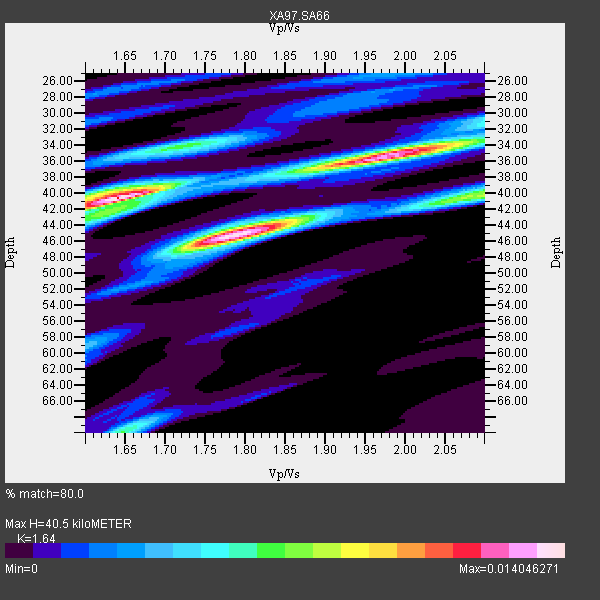
5 with match > 90% ( 21.73913 %) and 9 with match > 80% ( 39.130436 %) out of 23.
Download stack as xyz text file.
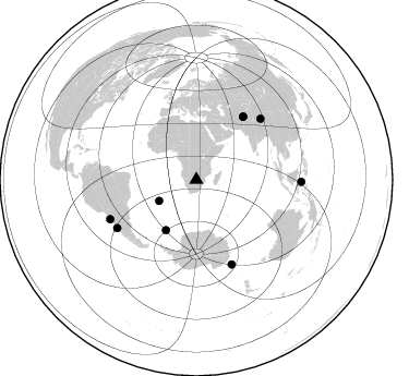
Azimuth Distribution of Events:
Prior Results for this Station
| Study | Thickness | Vp/Vs | Vp | Vs | Poissons Ratio | Extra |
| EARS | 40 km | 1.64 | 6.459 km/s | 3.939 km/s | 0.20 | |
| Crust2.0 | 37 km | 1.76 | 6.459 km/s | 3.665 km/s | 0.26 | G1,Archean, no seds. |
| Global Maxima | 40 km | 1.64 | 6.459 km/s | 3.939 km/s | 0.20 | amp=0.014046271 |
| Local Maxima 1 | 45 km | 1.78 | 6.459 km/s | 3.624 km/s | 0.27 | amp=0.013745901 |
| Local Maxima 2 | 35 km | 1.98 | 6.459 km/s | 3.258 km/s | 0.33 | amp=0.01155608 |
| Local Maxima 3 | 40 km | 2.09 | 6.459 km/s | 3.094 km/s | 0.35 | amp=0.0067932275 |
| Local Maxima 4 | 34 km | 1.72 | 6.459 km/s | 3.75 km/s | 0.25 | amp=0.006428811 |
| Predicted Arrivals for vertical incidence (zero ray parameter) | |
| Ps | 4.01 SECOND |
| PpPs | 16.55 SECOND |
| PsPs/PpSs | 20.57 SECOND |
Events Processed for this Station
Download zip of receiver functions as SAC
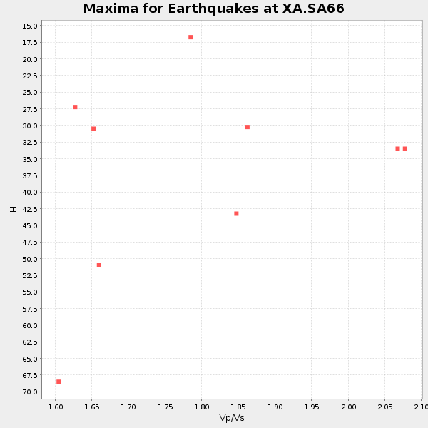
Plot maxima for each earthquake.
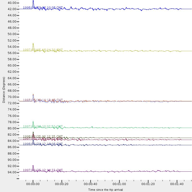
Events Used in the Stack
(9 events)| Radial Match | Distance | Baz | FERegion | Time | Lat/Lon | Depth | Magnitude |
| 98.761116 | 84.4 deg | 157.324 deg | Balleny Islands Region | 1998/03/25 03:12:25 GMT | (-62.9, 149.5) | 10 km | 6.6 MB, 8.0 MS, 8.3 UNKNOWN, 8.1 MW |
| 96.37634 | 80.9 deg | 46.568 deg | Xizang | 1997/11/08 10:02:52 GMT | (35.1, 87.3) | 33 km | 6.2 MB, 7.9 MS, 7.7 UNKNOWN, 7.6 MW |
| 96.35529 | 87.0 deg | 245.557 deg | Near Coast Of Northern Chile | 1998/01/30 12:16:08 GMT | (-23.9, -70.2) | 42 km | 6.3 MB, 6.5 MS, 7.0 UNKNOWN, 6.7 ME |
| 95.3723 | 71.7 deg | 36.612 deg | Hindu Kush Region, Afghanistan | 1997/05/13 14:13:45 GMT | (36.4, 70.9) | 196 km | 6.1 MB, 6.5 UNKNOWN, 6.4 MW |
| 95.335335 | 85.2 deg | 238.737 deg | Near Coast Of Central Chile | 1997/10/15 01:03:33 GMT | (-30.9, -71.2) | 58 km | 6.8 MB, 6.8 MS, 7.3 UNKNOWN, 7.1 MW |
| 87.07304 | 71.8 deg | 36.65 deg | Afghanistan-Tajikistan Bord Reg. | 1998/02/20 12:18:06 GMT | (36.5, 71.1) | 236 km | 5.8 MB, 5.7 MS, 6.4 UNKNOWN, 6.3 MW |
| 86.76195 | 54.1 deg | 211.024 deg | South Sandwich Islands Region | 1997/10/05 18:04:30 GMT | (-59.7, -29.2) | 274 km | 6.0 MB, 6.3 UNKNOWN, 6.3 MW |
| 85.898994 | 96.2 deg | 91.143 deg | Minahassa Peninsula, Sulawesi | 1997/11/25 12:14:33 GMT | (1.2, 122.5) | 24 km | 6.1 MB, 6.8 MS, 7.1 UNKNOWN, 6.7 ME |
| 82.47307 | 39.4 deg | 240.401 deg | Southern Mid-Atlantic Ridge | 1998/01/03 06:10:08 GMT | (-35.5, -16.2) | 10 km | 5.9 MS, 5.4 MB, 6.3 UNKNOWN, 6.1 MW |
Losers
(14 events)| Radial Match | Distance | Baz | FERegion | Time | Lat/Lon | Depth | Magnitude | Reason |
| 76.421646 | 38.7 deg | 84.77 deg | Mid-Indian Ridge | 1997/09/25 14:20:48 GMT | (-13.8, 66.2) | 10 km | 5.3 MB, 5.7 MS, 6.0 UNKNOWN, 6.0 MW | |
| 74.09467 | 86.1 deg | 247.56 deg | Northern Chile | 1997/09/28 23:13:13 GMT | (-22.4, -68.4) | 107 km | 5.7 MB, 5.6 UNKNOWN, 5.6 MW | |
| 70.35985 | 77.9 deg | 319.995 deg | Azores Islands, Portugal | 1997/06/27 04:39:52 GMT | (38.3, -26.7) | 10 km | 5.6 MB, 5.4 MS, 5.9 UNKNOWN, 5.9 MW | |
| 68.95217 | 89.6 deg | 255.427 deg | Peru-Bolivia Border Region | 1997/11/28 22:53:41 GMT | (-13.7, -68.8) | 586 km | 6.4 MB, 6.6 UNKNOWN, 6.6 MW | |
| 66.674644 | 87.1 deg | 152.617 deg | West Of Macquarie Island | 1997/10/17 09:55:15 GMT | (-57.5, 148.0) | 10 km | 5.2 MB, 5.9 MS, 6.2 UNKNOWN, 6.0 MW | |
| 66.6194 | 48.9 deg | 126.787 deg | Mid-Indian Ridge | 1997/08/20 13:51:16 GMT | (-41.7, 80.1) | 10 km | 5.6 MB, 6.4 MS, 6.5 UNKNOWN, 6.4 MW | |
| 61.843807 | 84.0 deg | 247.757 deg | Jujuy Province, Argentina | 1997/07/20 10:14:22 GMT | (-23.0, -66.3) | 256 km | 5.7 MB, 6.1 UNKNOWN, 5.7 ME | |
| 61.644135 | 82.8 deg | 59.106 deg | Myanmar | 1997/12/30 13:43:18 GMT | (25.4, 96.6) | 33 km | 5.7 MS, 5.4 MB, 5.7 UNKNOWN, 5.7 MW | |
| 52.809204 | 86.2 deg | 240.105 deg | Near Coast Of Central Chile | 1997/07/19 12:22:57 GMT | (-29.3, -71.7) | 26 km | 5.8 MB, 5.5 MS, 5.9 UNKNOWN, 5.8 MW | |
| 45.3791 | 85.2 deg | 242.799 deg | Northern Chile | 1997/05/17 02:10:18 GMT | (-27.2, -69.5) | 106 km | 5.5 MB, 5.6 UNKNOWN, 5.5 MW | |
| 43.66197 | 86.8 deg | 249.597 deg | Chile-Bolivia Border Region | 1997/12/09 14:23:45 GMT | (-20.2, -68.4) | 133 km | 5.7 MB, 5.7 UNKNOWN, 5.7 MW | |
| 41.021206 | 87.4 deg | 98.238 deg | Sumbawa Region, Indonesia | 1997/10/23 01:16:01 GMT | (-8.7, 117.0) | 160 km | 5.5 MB | |
| 33.275444 | 82.7 deg | 93.22 deg | Java Sea | 1997/07/11 09:55:12 GMT | (-5.7, 110.8) | 574 km | 5.6 MB | |
| 23.24221 | 85.3 deg | 238.626 deg | Near Coast Of Central Chile | 1998/01/12 10:14:07 GMT | (-31.0, -71.4) | 35 km | 5.8 MB, 6.2 MS, 6.6 UNKNOWN, 6.2 ME |
