
Station XB C0213 - 991021
Network: XB14 - Sweetwater Array
Nearby stations (2 deg radius)
| Station | Name | (Lat, Lon) | Start / End | Elevation |
| C0213 | 991021 | (32.68, -100.41) | 2014-03-07 / 2014-12-31 | 616 m |
| Crust2 Type: | D8,thick Platform 3 km seds. |
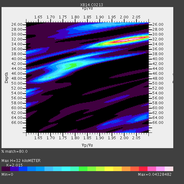
| Thickness Estimate: | 32 km |
| Thickness StdDev: | 1.0 km |
| Vp/Vs Estimate: | 2.02 |
| Vp/Vs StdDev: | 0.02 |
| Vs Estimate: | 3.189 km/s |
| Poisson's Ratio: | 0.34 |
| Peak Value: | 0.04 |
| Assumed Vp: | 6.426 km/s |
| Ps Weight: | 0.33333334 |
| PpPs Weight: | 0.33333334 |
| PsPs Weight: | 0.33333328 |
| Residual Complexity: | 0.595 |
| Nearby stations H: | 38 km +- 6.4 km |
| (2.0 deg) Vp/Vs: | 1.89 +- 0.18 |
2 with match > 90% ( 13.333333 %) and 4 with match > 80% ( 26.666666 %) out of 15.
Download stack as xyz text file.
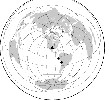
Azimuth Distribution of Events:
Prior Results for this Station
| Study | Thickness | Vp/Vs | Vp | Vs | Poissons Ratio | Extra |
| EARS | 32 km | 2.02 | 6.426 km/s | 3.189 km/s | 0.34 | |
| Crust2.0 | 46 km | 1.78 | 6.426 km/s | 3.613 km/s | 0.27 | D8,thick Platform 3 km seds. |
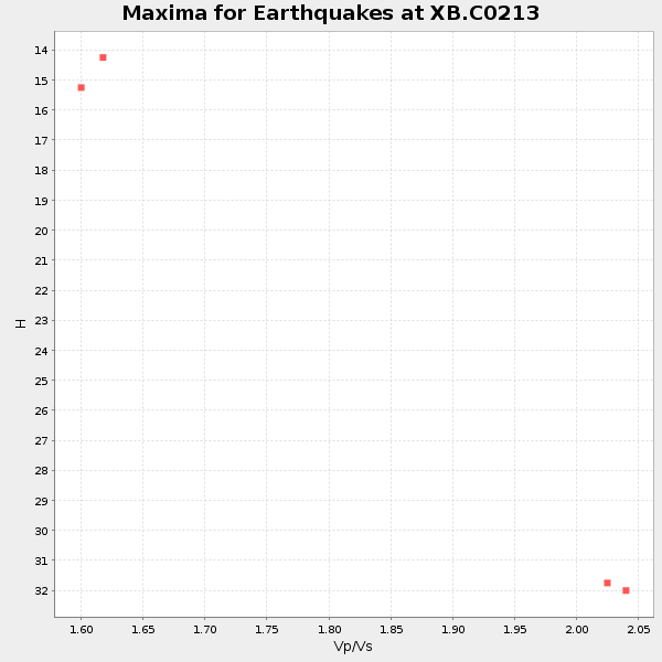
| Global Maxima | 32 km | 2.02 | 6.426 km/s | 3.189 km/s | 0.34 | amp=0.04328482 |
| Local Maxima 1 | 43 km | 1.79 | 6.426 km/s | 3.6 km/s | 0.27 | amp=0.019336317 |
| Local Maxima 2 | 47 km | 1.70 | 6.426 km/s | 3.791 km/s | 0.23 | amp=0.016707469 |
| Local Maxima 3 | 25 km | 1.92 | 6.426 km/s | 3.343 km/s | 0.31 | amp=0.011956997 |
| Local Maxima 4 | 42 km | 1.80 | 6.426 km/s | 3.57 km/s | 0.28 | amp=0.011513236 |
| Predicted Arrivals for vertical incidence (zero ray parameter) | |
| Ps | 5.05 SECOND |
| PpPs | 15.01 SECOND |
| PsPs/PpSs | 20.07 SECOND |
Events Processed for this Station
Download zip of receiver functions as SAC
Plot maxima for each earthquake.
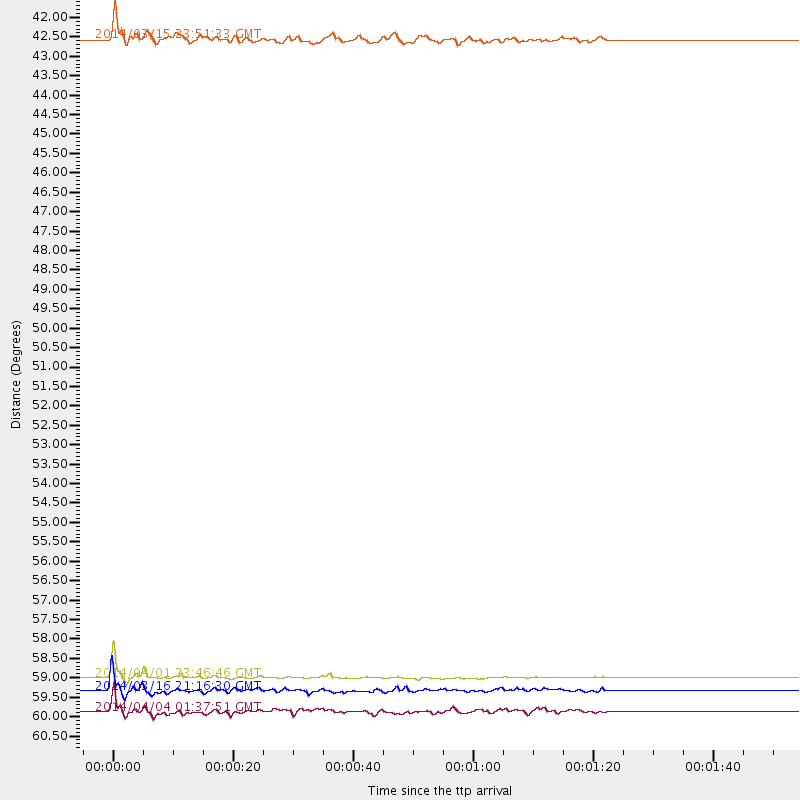
Events Used in the Stack
(4 events)| Radial Match | Distance | Baz | FERegion | Time | Lat/Lon | Depth | Magnitude |
| 99.23046 | 59.2 deg | 147.202 deg | Near Coast Of Northern Chile | 2014/04/01 23:46:46 GMT | (-19.6, -70.8) | 20 km | 8.2 MWW, 8.0 MI, 8.1 MWC |
| 91.529274 | 59.6 deg | 147.18 deg | Near Coast Of Northern Chile | 2014/03/16 21:16:30 GMT | (-19.9, -70.6) | 20 km | 6.7 MWW, 6.7 MWC, 7.0 MI |
| 86.290016 | 42.3 deg | 150.5 deg | Near Coast Of Northern Peru | 2014/03/15 23:51:33 GMT | (-5.6, -81.0) | 29 km | 6.3 MWW, 6.2 MWB, 6.3 MWC |
| 80.03961 | 60.1 deg | 147.674 deg | Near Coast Of Northern Chile | 2014/04/04 01:37:51 GMT | (-20.6, -70.7) | 20 km | 6.1 MWP, 6.1 MWB, 6.1 MWW, 6.3 MWC |
Losers
(11 events)| Radial Match | Distance | Baz | FERegion | Time | Lat/Lon | Depth | Magnitude | Reason |
| 85.05281 | 59.4 deg | 147.371 deg | Near Coast Of Northern Chile | 2014/04/02 00:03:12 GMT | (-19.8, -70.9) | 10 km | 5.8 MB | |
| 79.72713 | 60.1 deg | 147.675 deg | Near Coast Of Northern Chile | 2014/04/03 03:11:14 GMT | (-20.6, -70.7) | 10 km | 5.8 MB | |
| 79.70164 | 59.9 deg | 147.304 deg | Near Coast Of Northern Chile | 2014/04/03 01:58:31 GMT | (-20.3, -70.6) | 23 km | 6.5 MWW, 6.5 MWB, 6.6 MWC | |
| 70.62485 | 49.6 deg | 333.699 deg | Northern Alaska | 2014/04/18 18:44:17 GMT | (67.7, -162.5) | 1.0 km | 5.5 MB, 5.4 MI | |
| 70.57455 | 88.6 deg | 244.334 deg | Tonga Islands | 2014/04/26 06:02:16 GMT | (-20.7, -174.7) | 10 km | 6.5 MWP | |
| 69.806694 | 51.9 deg | 149.778 deg | Near Coast Of Peru | 2014/03/15 08:59:21 GMT | (-14.1, -76.3) | 20 km | 6.1 MWW, 6.0 MWB, 6.2 MWC | |
| 67.39933 | 59.7 deg | 147.538 deg | Near Coast Of Northern Chile | 2014/04/07 13:43:20 GMT | (-20.2, -70.9) | 7.9 km | 5.8 MWB, 5.7 MWW, 5.7 MWC | |
| 64.212845 | 58.6 deg | 313.695 deg | Andreanof Islands, Aleutian Is. | 2014/03/13 13:20:59 GMT | (51.2, -179.1) | 26 km | 5.6 MWC, 5.1 ML, 5.4 MWW, 5.4 MWB, 5.5 ML, 5.6 MWC | |
| 60.962105 | 59.4 deg | 146.495 deg | Near Coast Of Northern Chile | 2014/04/01 23:59:57 GMT | (-19.5, -70.2) | 22 km | 5.8 MB | |
| 53.09614 | 59.9 deg | 147.783 deg | Near Coast Of Northern Chile | 2014/04/08 10:14:32 GMT | (-20.5, -70.9) | 7.1 km | 5.7 MWB, 5.5 MWR, 5.6 MWC, 5.6 MWW | |
| 49.82878 | 60.1 deg | 147.651 deg | Near Coast Of Northern Chile | 2014/04/13 12:11:30 GMT | (-20.6, -70.7) | 13 km | 5.5 MWW, 5.3 MWR |

