
Station XC ARPA - Arthurs Pass
Network: XC95 - Southern Alps Passive Seismic Experiment
Nearby stations (2 deg radius)
| Station | Name | (Lat, Lon) | Start / End | Elevation |
| ARPA | Arthurs Pass | (-42.97, 171.58) | 1995-11-11 / 1996-12-31 | 710 m |
| Crust2 Type: | K2,forearc, New Zealand, 0.7 km seds. |
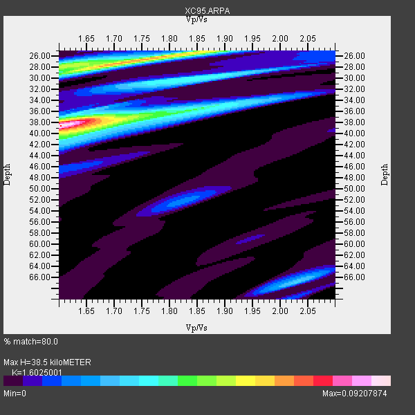
| Thickness Estimate: | 38 km |
| Thickness StdDev: | 0.5 km |
| Vp/Vs Estimate: | 1.60 |
| Vp/Vs StdDev: | 0.03 |
| Vs Estimate: | 4.032 km/s |
| Poisson's Ratio: | 0.18 |
| Peak Value: | 0.09 |
| Assumed Vp: | 6.461 km/s |
| Ps Weight: | 0.33333334 |
| PpPs Weight: | 0.33333334 |
| PsPs Weight: | 0.33333328 |
| Residual Complexity: | 0.738 |
| Nearby stations H: | +- |
| (2.0 deg) Vp/Vs: | +- |
1 with match > 90% ( 11.111111 %) and 2 with match > 80% ( 22.222221 %) out of 9.
Download stack as xyz text file.
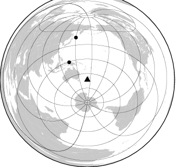
Azimuth Distribution of Events:
Prior Results for this Station
| Study | Thickness | Vp/Vs | Vp | Vs | Poissons Ratio | Extra |
| EARS | 38 km | 1.60 | 6.461 km/s | 4.032 km/s | 0.18 | |
| Crust2.0 | 35 km | 1.76 | 6.461 km/s | 3.663 km/s | 0.26 | K2,forearc, New Zealand, 0.7 km seds. |
| Global Maxima | 38 km | 1.60 | 6.461 km/s | 4.032 km/s | 0.18 | amp=0.09207874 |
| Local Maxima 1 | 27 km | 1.72 | 6.461 km/s | 3.757 km/s | 0.24 | amp=0.06725141 |
| Local Maxima 2 | 39 km | 1.67 | 6.461 km/s | 3.875 km/s | 0.22 | amp=0.040114857 |
| Local Maxima 3 | 30 km | 1.84 | 6.461 km/s | 3.507 km/s | 0.29 | amp=0.03394599 |
| Local Maxima 4 | 28 km | 1.61 | 6.461 km/s | 4.026 km/s | 0.18 | amp=0.033293918 |
| Predicted Arrivals for vertical incidence (zero ray parameter) | |
| Ps | 3.59 SECOND |
| PpPs | 15.51 SECOND |
| PsPs/PpSs | 19.10 SECOND |
Events Processed for this Station
Download zip of receiver functions as SAC
Plot maxima for each earthquake.
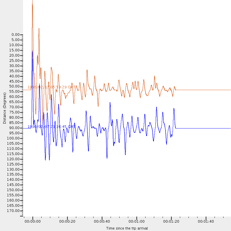
Events Used in the Stack
(2 events)| Radial Match | Distance | Baz | FERegion | Time | Lat/Lon | Depth | Magnitude |
| 95.40902 | 52.0 deg | 313.981 deg | Irian Jaya Region, Indonesia | 1996/02/17 05:59:29 GMT | (-0.9, 137.0) | 33 km | 6.5 MB, 8.1 MS, 7.9 UNKNOWN |
| 88.474724 | 90.0 deg | 344.899 deg | Kuril Islands | 1996/02/07 21:36:45 GMT | (45.3, 149.9) | 33 km | 6.3 MB, 7.0 MS, 7.2 UNKNOWN, 7.1 MW |
Losers
(7 events)| Radial Match | Distance | Baz | FERegion | Time | Lat/Lon | Depth | Magnitude | Reason |
| 74.1411 | 48.0 deg | 315.738 deg | Irian Jaya, Indonesia | 1995/12/19 23:28:12 GMT | (-3.7, 140.3) | 71 km | 6.2 MB, 6.5 UNKNOWN | |
| 72.53223 | 89.4 deg | 344.126 deg | Kuril Islands | 1995/11/24 17:24:12 GMT | (44.5, 149.1) | 33 km | 6.1 MB, 6.3 MS, 6.1 UNKNOWN, 6.6 MW | |
| 65.21741 | 36.3 deg | 338.001 deg | Solomon Islands | 1996/01/11 03:51:34 GMT | (-8.4, 158.6) | 96 km | 5.5 MB, 5.6 UNKNOWN, 5.9 MW | |
| 59.282234 | 90.0 deg | 345.223 deg | Kuril Islands | 1996/02/14 20:31:06 GMT | (45.4, 150.4) | 33 km | 5.9 MB, 5.2 MS, 5.8 UNKNOWN, 5.8 MW | |
| 56.686573 | 89.4 deg | 344.328 deg | Kuril Islands | 1995/12/03 18:01:08 GMT | (44.6, 149.4) | 33 km | 6.6 MB, 8.0 MS | |
| 55.689102 | 84.2 deg | 337.068 deg | Off East Coast Of Honshu, Japan | 1996/02/16 15:22:57 GMT | (37.3, 142.5) | 33 km | 6.2 MB, 6.2 MS, 6.7 UNKNOWN, 6.6 MW | |
| 52.35425 | 52.8 deg | 312.894 deg | Irian Jaya Region, Indonesia | 1996/02/18 00:22:23 GMT | (-0.7, 135.9) | 33 km | 5.7 MS, 5.2 MB |
