
Station XC BERA - Berwen
Network: XC95 - Southern Alps Passive Seismic Experiment
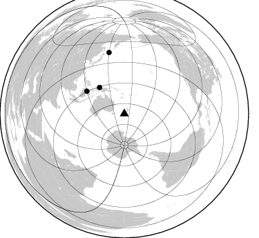
Nearby stations (2 deg radius)
| Station | Name | (Lat, Lon) | Start / End | Elevation |
| BERA | Berwen | (-44.53, 169.88) | 1995-11-16 / 1996-12-31 | 505 m |
| Crust2 Type: | K2,forearc, New Zealand, 0.7 km seds. |
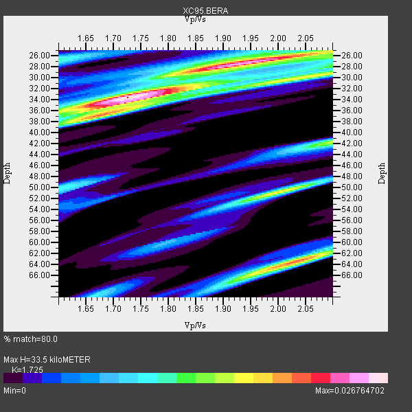
| Thickness Estimate: | 34 km |
| Thickness StdDev: | 14 km |
| Vp/Vs Estimate: | 1.73 |
| Vp/Vs StdDev: | 0.12 |
| Vs Estimate: | 3.746 km/s |
| Poisson's Ratio: | 0.25 |
| Peak Value: | 0.03 |
| Assumed Vp: | 6.461 km/s |
| Ps Weight: | 0.33333334 |
| PpPs Weight: | 0.33333334 |
| PsPs Weight: | 0.33333328 |
| Residual Complexity: | 0.744 |
| Nearby stations H: | +- |
| (2.0 deg) Vp/Vs: | +- |
2 with match > 90% ( 22.222221 %) and 3 with match > 80% ( 33.333332 %) out of 9.
Download stack as xyz text file.
Azimuth Distribution of Events:
Prior Results for this Station
| Study | Thickness | Vp/Vs | Vp | Vs | Poissons Ratio | Extra |
| EARS | 34 km | 1.73 | 6.461 km/s | 3.746 km/s | 0.25 | |
| Crust2.0 | 35 km | 1.76 | 6.461 km/s | 3.663 km/s | 0.26 | K2,forearc, New Zealand, 0.7 km seds. |
| Global Maxima | 34 km | 1.73 | 6.461 km/s | 3.746 km/s | 0.25 | amp=0.026764702 |
| Local Maxima 1 | 27 km | 1.94 | 6.461 km/s | 3.331 km/s | 0.32 | amp=0.023741465 |
| Local Maxima 2 | 63 km | 2.04 | 6.461 km/s | 3.175 km/s | 0.34 | amp=0.020451048 |
| Local Maxima 3 | 50 km | 2.01 | 6.461 km/s | 3.219 km/s | 0.33 | amp=0.017461197 |
| Local Maxima 4 | 42 km | 2.10 | 6.461 km/s | 3.081 km/s | 0.35 | amp=0.015793128 |
| Predicted Arrivals for vertical incidence (zero ray parameter) | |
| Ps | 3.76 SECOND |
| PpPs | 14.13 SECOND |
| PsPs/PpSs | 17.89 SECOND |
Events Processed for this Station
Download zip of receiver functions as SAC
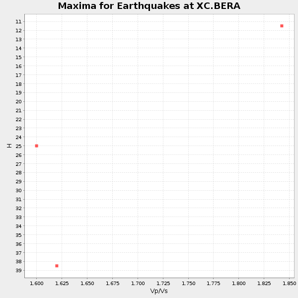
Plot maxima for each earthquake.
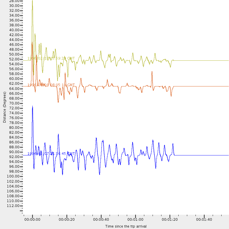
Events Used in the Stack
(3 events)| Radial Match | Distance | Baz | FERegion | Time | Lat/Lon | Depth | Magnitude |
| 97.58787 | 63.1 deg | 300.972 deg | Minahassa Peninsula, Sulawesi | 1996/01/01 08:05:11 GMT | (0.7, 120.0) | 33 km | 6.2 MB, 7.7 MS, 7.8 UNKNOWN, 7.8 MW |
| 95.343315 | 52.2 deg | 316.678 deg | Irian Jaya Region, Indonesia | 1996/02/17 05:59:29 GMT | (-0.9, 137.0) | 33 km | 6.5 MB, 8.1 MS, 7.9 UNKNOWN |
| 83.54228 | 91.2 deg | 346.051 deg | Kuril Islands | 1996/02/07 21:36:45 GMT | (45.3, 149.9) | 33 km | 6.3 MB, 7.0 MS, 7.2 UNKNOWN, 7.1 MW |
Losers
(6 events)| Radial Match | Distance | Baz | FERegion | Time | Lat/Lon | Depth | Magnitude | Reason |
| 73.1374 | 60.3 deg | 307.243 deg | Northern Molucca Sea | 1996/02/28 09:44:09 GMT | (1.7, 126.1) | 103 km | 6.1 MB, 6.4 UNKNOWN, 6.4 MW | |
| 66.44584 | 88.2 deg | 340.094 deg | Off East Coast Of Honshu, Japan | 1995/12/30 12:17:37 GMT | (40.8, 143.3) | 33 km | 5.7 MB, 5.6 MS | |
| 66.385345 | 43.5 deg | 325.101 deg | Eastern New Guinea Reg., P.N.G. | 1996/03/02 01:50:04 GMT | (-6.0, 146.6) | 59 km | 6.0 MB, 6.1 MS, 6.2 UNKNOWN, 6.0 MS | |
| 65.67562 | 30.4 deg | 355.317 deg | Vanuatu Islands | 1996/02/27 18:03:04 GMT | (-14.1, 167.4) | 33 km | 5.6 MB, 5.6 MS, 5.7 UNKNOWN | |
| 60.049603 | 48.3 deg | 318.659 deg | Irian Jaya, Indonesia | 1995/12/19 23:28:12 GMT | (-3.7, 140.3) | 71 km | 6.2 MB, 6.5 UNKNOWN | |
| 38.59503 | 81.0 deg | 316.85 deg | Taiwan Region | 1996/03/29 03:28:56 GMT | (24.1, 122.2) | 33 km | 5.5 MS, 5.4 MB, 5.8 UNKNOWN, 5.7 MW |
