
Station XC CLIA - Clinton
Network: XC95 - Southern Alps Passive Seismic Experiment
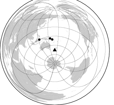
Nearby stations (2 deg radius)
| Station | Name | (Lat, Lon) | Start / End | Elevation |
| CLIA | Clinton | (-46.29, 169.31) | 1995-11-12 / 1997-12-31 | 352 m |
| Crust2 Type: | S1,continental slope, margin, transition 1 km seds. |
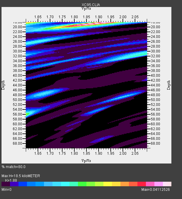
| Thickness Estimate: | 18 km |
| Thickness StdDev: | 17 km |
| Vp/Vs Estimate: | 1.88 |
| Vp/Vs StdDev: | 0.14 |
| Vs Estimate: | 3.289 km/s |
| Poisson's Ratio: | 0.30 |
| Peak Value: | 0.04 |
| Assumed Vp: | 6.183 km/s |
| Ps Weight: | 0.33333334 |
| PpPs Weight: | 0.33333334 |
| PsPs Weight: | 0.33333328 |
| Residual Complexity: | 0.601 |
| Nearby stations H: | +- |
| (2.0 deg) Vp/Vs: | +- |
0 with match > 90% ( 0.0 %) and 3 with match > 80% ( 20.0 %) out of 15.
Download stack as xyz text file.
Azimuth Distribution of Events:
Prior Results for this Station
| Study | Thickness | Vp/Vs | Vp | Vs | Poissons Ratio | Extra |
| EARS | 18 km | 1.88 | 6.183 km/s | 3.289 km/s | 0.30 | |
| Crust2.0 | 23 km | 1.81 | 6.183 km/s | 3.422 km/s | 0.28 | S1,continental slope, margin, transition 1 km seds. |
| Global Maxima | 18 km | 1.88 | 6.183 km/s | 3.289 km/s | 0.30 | amp=0.04112526 |
| Local Maxima 1 | 18 km | 1.61 | 6.183 km/s | 3.852 km/s | 0.18 | amp=0.027487459 |
| Local Maxima 2 | 56 km | 1.60 | 6.183 km/s | 3.864 km/s | 0.18 | amp=0.023252439 |
| Local Maxima 3 | 26 km | 1.64 | 6.183 km/s | 3.77 km/s | 0.20 | amp=0.01656857 |
| Local Maxima 4 | 32 km | 2.05 | 6.183 km/s | 3.02 km/s | 0.34 | amp=0.014126855 |
| Predicted Arrivals for vertical incidence (zero ray parameter) | |
| Ps | 2.63 SECOND |
| PpPs | 8.62 SECOND |
| PsPs/PpSs | 11.25 SECOND |
Events Processed for this Station
Download zip of receiver functions as SAC
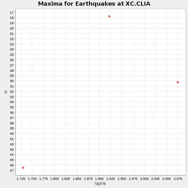
Plot maxima for each earthquake.
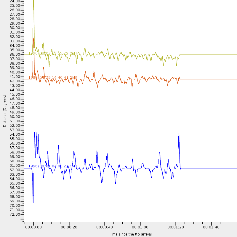
Events Used in the Stack
(3 events)| Radial Match | Distance | Baz | FERegion | Time | Lat/Lon | Depth | Magnitude |
| 87.79798 | 36.0 deg | 346.78 deg | Solomon Islands | 1996/08/02 12:55:29 GMT | (-10.8, 161.4) | 33 km | 6.2 MB, 7.1 MS, 6.9 UNKNOWN, 6.9 MW |
| 87.416084 | 61.4 deg | 304.469 deg | Minahassa Peninsula, Sulawesi | 1996/08/01 04:08:23 GMT | (-0.0, 122.9) | 149 km | 5.5 MB, 5.6 UNKNOWN, 5.5 MW |
| 83.629364 | 41.5 deg | 338.242 deg | Solomon Islands | 1996/04/29 14:40:41 GMT | (-6.5, 155.0) | 44 km | 6.3 MB, 7.5 MS, 7.2 UNKNOWN, 6.8 ME |
Losers
(12 events)| Radial Match | Distance | Baz | FERegion | Time | Lat/Lon | Depth | Magnitude | Reason |
| 76.14192 | 49.4 deg | 320.332 deg | Irian Jaya, Indonesia | 1995/12/19 23:28:12 GMT | (-3.7, 140.3) | 71 km | 6.2 MB, 6.5 UNKNOWN | |
| 75.34788 | 55.9 deg | 299.248 deg | Flores Sea | 1996/06/17 11:22:18 GMT | (-7.1, 122.6) | 587 km | 6.6 MB, 7.9 UNKNOWN, 7.8 MW | |
| 74.441696 | 63.7 deg | 302.836 deg | Minahassa Peninsula, Sulawesi | 1996/07/22 14:19:35 GMT | (1.0, 120.4) | 33 km | 6.0 MB, 6.9 MS, 7.0 UNKNOWN, 6.9 MW | |
| 71.940895 | 32.9 deg | 355.295 deg | Vanuatu Islands | 1996/08/11 01:31:16 GMT | (-13.4, 166.7) | 100 km | 5.6 MB, 5.8 MS, 6.1 UNKNOWN, 6.0 MW | |
| 67.31323 | 40.7 deg | 338.681 deg | Solomon Islands | 1996/10/14 00:07:58 GMT | (-7.2, 155.5) | 33 km | 5.8 MS, 5.4 MB | |
| 65.0378 | 79.5 deg | 192.339 deg | Southwest Of Africa | 1996/09/20 17:37:06 GMT | (-53.1, 9.7) | 10 km | 5.6 MB | |
| 63.210823 | 41.7 deg | 337.663 deg | Solomon Islands | 1996/05/02 02:32:35 GMT | (-6.4, 154.6) | 33 km | 5.3 MB, 5.9 MS, 6.0 UNKNOWN, 5.9 MW | |
| 56.251144 | 34.2 deg | 31.16 deg | Tonga Islands | 1996/08/05 02:08:58 GMT | (-15.3, -173.1) | 41 km | 6.0 MB, 6.7 MS, 6.7 UNKNOWN, 6.2 ME | |
| 52.87072 | 43.8 deg | 334.838 deg | New Britain Region, P.N.G. | 1996/08/10 11:20:19 GMT | (-4.9, 152.1) | 33 km | 5.6 MB, 6.0 MS, 6.2 UNKNOWN, 6.1 MW | |
| 50.085464 | 93.1 deg | 338.255 deg | Eastern Sea Of Japan | 1996/12/22 14:53:27 GMT | (43.2, 138.9) | 227 km | 6.0 MB, 6.5 UNKNOWN, 6.5 MW | |
| 41.400795 | 72.9 deg | 210.343 deg | Prince Edward Islands Region | 1996/02/28 10:03:07 GMT | (-51.8, 40.3) | 10 km | 5.5 MB, 5.4 MS | |
| 30.970278 | 48.0 deg | 332.929 deg | New Ireland Region, P.N.G. | 1996/11/01 03:32:34 GMT | (-1.3, 149.5) | 33 km | 5.7 MB, 5.7 MS, 5.9 UNKNOWN, 5.8 MW |
