
Station XC EWZA - Erewhon
Network: XC95 - Southern Alps Passive Seismic Experiment
Nearby stations (2 deg radius)
| Station | Name | (Lat, Lon) | Start / End | Elevation |
| EWZA | Erewhon | (-43.51, 170.85) | 1995-11-11 / 1996-12-31 | 625 m |
| Crust2 Type: | K2,forearc, New Zealand, 0.7 km seds. |
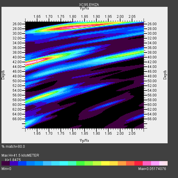
| Thickness Estimate: | 42 km |
| Thickness StdDev: | 10 km |
| Vp/Vs Estimate: | 1.65 |
| Vp/Vs StdDev: | 0.08 |
| Vs Estimate: | 3.922 km/s |
| Poisson's Ratio: | 0.21 |
| Peak Value: | 0.05 |
| Assumed Vp: | 6.461 km/s |
| Ps Weight: | 0.33333334 |
| PpPs Weight: | 0.33333334 |
| PsPs Weight: | 0.33333328 |
| Residual Complexity: | 0.857 |
| Nearby stations H: | +- |
| (2.0 deg) Vp/Vs: | +- |
2 with match > 90% ( 15.384615 %) and 3 with match > 80% ( 23.076923 %) out of 13.
Download stack as xyz text file.
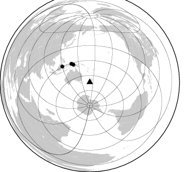
Azimuth Distribution of Events:
Prior Results for this Station
| Study | Thickness | Vp/Vs | Vp | Vs | Poissons Ratio | Extra |
| EARS | 42 km | 1.65 | 6.461 km/s | 3.922 km/s | 0.21 | |
| Crust2.0 | 35 km | 1.76 | 6.461 km/s | 3.663 km/s | 0.26 | K2,forearc, New Zealand, 0.7 km seds. |
| Global Maxima | 42 km | 1.65 | 6.461 km/s | 3.922 km/s | 0.21 | amp=0.05174076 |
| Local Maxima 1 | 27 km | 1.82 | 6.461 km/s | 3.545 km/s | 0.28 | amp=0.048031263 |
| Local Maxima 2 | 56 km | 1.66 | 6.461 km/s | 3.881 km/s | 0.22 | amp=0.033733916 |
| Local Maxima 3 | 38 km | 2.04 | 6.461 km/s | 3.175 km/s | 0.34 | amp=0.03023256 |
| Local Maxima 4 | 27 km | 1.75 | 6.461 km/s | 3.682 km/s | 0.26 | amp=0.023932017 |
| Predicted Arrivals for vertical incidence (zero ray parameter) | |
| Ps | 4.16 SECOND |
| PpPs | 17.00 SECOND |
| PsPs/PpSs | 21.16 SECOND |
Events Processed for this Station
Download zip of receiver functions as SAC
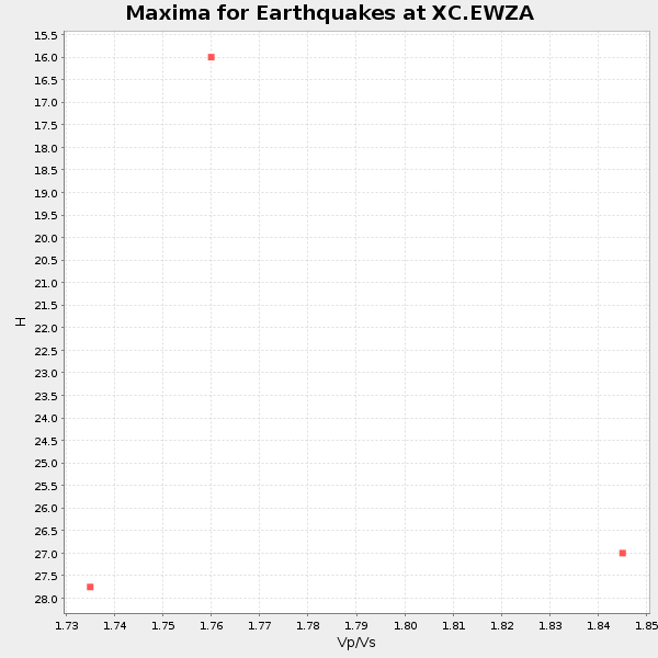
Plot maxima for each earthquake.
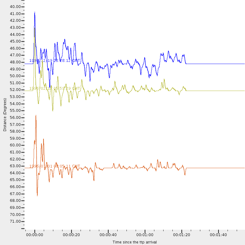
Events Used in the Stack
(3 events)| Radial Match | Distance | Baz | FERegion | Time | Lat/Lon | Depth | Magnitude |
| 97.28851 | 63.2 deg | 299.678 deg | Minahassa Peninsula, Sulawesi | 1996/01/01 08:05:11 GMT | (0.7, 120.0) | 33 km | 6.2 MB, 7.7 MS, 7.8 UNKNOWN, 7.8 MW |
| 93.10415 | 52.0 deg | 315.065 deg | Irian Jaya Region, Indonesia | 1996/02/17 05:59:29 GMT | (-0.9, 137.0) | 33 km | 6.5 MB, 8.1 MS, 7.9 UNKNOWN |
| 84.476105 | 48.0 deg | 316.911 deg | Irian Jaya, Indonesia | 1995/12/19 23:28:12 GMT | (-3.7, 140.3) | 71 km | 6.2 MB, 6.5 UNKNOWN |
Losers
(10 events)| Radial Match | Distance | Baz | FERegion | Time | Lat/Lon | Depth | Magnitude | Reason |
| 77.17659 | 89.8 deg | 344.829 deg | Kuril Islands | 1995/12/03 18:01:08 GMT | (44.6, 149.4) | 33 km | 6.6 MB, 8.0 MS | |
| 62.73843 | 60.3 deg | 305.868 deg | Northern Molucca Sea | 1996/02/28 09:44:09 GMT | (1.7, 126.1) | 103 km | 6.1 MB, 6.4 UNKNOWN, 6.4 MW | |
| 61.84531 | 43.0 deg | 323.251 deg | Eastern New Guinea Reg., P.N.G. | 1996/02/09 17:33:52 GMT | (-6.0, 146.6) | 54 km | 5.6 MB, 5.8 MS, 6.0 UNKNOWN, 5.9 MW | |
| 60.742104 | 52.9 deg | 314.055 deg | Irian Jaya Region, Indonesia | 1996/02/17 14:21:23 GMT | (-0.6, 135.9) | 33 km | 5.8 MB, 6.7 MS, 6.7 UNKNOWN, 6.4 MW | |
| 51.49955 | 77.6 deg | 333.008 deg | Southeast Of Honshu, Japan | 1996/02/14 21:26:56 GMT | (29.2, 140.4) | 142 km | 5.9 MB | |
| 50.336338 | 49.6 deg | 307.726 deg | Aru Islands Region, Indonesia | 1996/01/10 22:36:03 GMT | (-6.1, 133.6) | 37 km | 5.8 MB, 5.6 MS, 6.0 UNKNOWN, 5.9 MW | |
| 49.315865 | 73.1 deg | 308.9 deg | Mindoro, Philippines | 1996/02/18 09:57:16 GMT | (13.9, 120.8) | 242 km | 5.6 UNKNOWN, 5.4 MB | |
| 47.759987 | 61.4 deg | 307.606 deg | Talaud Islands, Indonesia | 1995/11/13 02:17:51 GMT | (3.6, 126.7) | 33 km | 5.8 MB, 6.1 MS, 6.3 UNKNOWN, 6.1 MW | |
| 45.831787 | 81.2 deg | 282.695 deg | Off W Coast Of Northern Sumatra | 1995/11/22 13:27:53 GMT | (3.1, 95.9) | 28 km | 5.5 MB, 5.7 MS, 5.8 UNKNOWN, 5.8 MW | |
| 13.913741 | 89.7 deg | 344.796 deg | Kuril Islands | 1996/01/31 20:30:47 GMT | (44.5, 149.4) | 58 km | 5.8 MB, 6.1 UNKNOWN, 5.9 MW |
