
Station XE YAN - YANERT
Network: XE99 - Broadband Experiment Across Alaskan Range
Nearby stations (2 deg radius)
| Station | Name | (Lat, Lon) | Start / End | Elevation |
| YAN | YANERT | (63.66, -148.77) | 1999-06-28 / 2001-12-31 | 781 m |
| Crust2 Type: | L8,thin continental arc, Cordilleras, 0.5 km seds. |
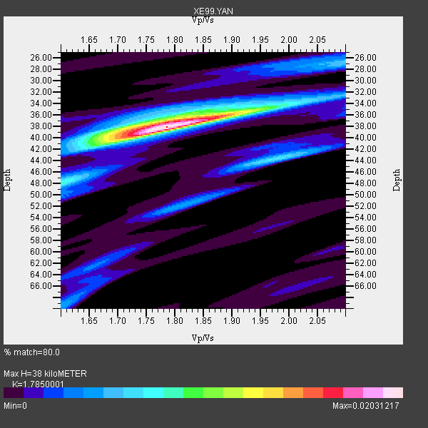
| Thickness Estimate: | 38 km |
| Thickness StdDev: | 3.1 km |
| Vp/Vs Estimate: | 1.79 |
| Vp/Vs StdDev: | 0.07 |
| Vs Estimate: | 3.679 km/s |
| Poisson's Ratio: | 0.27 |
| Peak Value: | 0.02 |
| Assumed Vp: | 6.566 km/s |
| Ps Weight: | 0.33333334 |
| PpPs Weight: | 0.33333334 |
| PsPs Weight: | 0.33333328 |
| Residual Complexity: | 0.501 |
| Nearby stations H: | +- |
| (2.0 deg) Vp/Vs: | +- |
6 with match > 90% ( 31.578947 %) and 19 with match > 80% ( 100.0 %) out of 19.
Download stack as xyz text file.
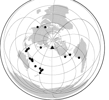
Azimuth Distribution of Events:
Prior Results for this Station
| Study | Thickness | Vp/Vs | Vp | Vs | Poissons Ratio | Extra |
| EARS | 38 km | 1.79 | 6.566 km/s | 3.679 km/s | 0.27 | |
| Crust2.0 | 34 km | 1.77 | 6.566 km/s | 3.707 km/s | 0.27 | L8,thin continental arc, Cordilleras, 0.5 km seds. |
| Global Maxima | 38 km | 1.79 | 6.566 km/s | 3.679 km/s | 0.27 | amp=0.02031217 |
| Local Maxima 1 | 38 km | 1.73 | 6.566 km/s | 3.795 km/s | 0.25 | amp=0.007967269 |
| Local Maxima 2 | 44 km | 1.98 | 6.566 km/s | 3.316 km/s | 0.33 | amp=0.007171584 |
| Local Maxima 3 | 48 km | 1.60 | 6.566 km/s | 4.104 km/s | 0.18 | amp=0.006035858 |
| Local Maxima 4 | 35 km | 1.95 | 6.566 km/s | 3.367 km/s | 0.32 | amp=0.0051750443 |
| Predicted Arrivals for vertical incidence (zero ray parameter) | |
| Ps | 4.54 SECOND |
| PpPs | 16.12 SECOND |
| PsPs/PpSs | 20.66 SECOND |
Events Processed for this Station
Download zip of receiver functions as SAC
Plot maxima for each earthquake.
Events Used in the Stack
(19 events)| Radial Match | Distance | Baz | FERegion | Time | Lat/Lon | Depth | Magnitude |
| 95.24373 | 65.3 deg | 111.596 deg | El Salvador | 2001/01/13 17:33:32 GMT | (13.0, -88.7) | 60 km | 6.4 MB, 7.8 MS, 7.7 MW, 7.5 ME |
| 95.14023 | 81.0 deg | 238.79 deg | New Ireland Region, P.N.G. | 2000/11/16 05:21:22 GMT | (-5.1, 153.2) | 33 km | 6.0 MB |
| 95.07896 | 98.0 deg | 110.372 deg | Near Coast Of Peru | 2001/06/23 20:33:14 GMT | (-16.3, -73.6) | 33 km | 6.7 MB, 8.2 MS, 8.4 MW, 7.8 ME |
| 94.24304 | 81.5 deg | 268.28 deg | Mindanao, Philippines | 2001/01/01 06:57:04 GMT | (6.9, 126.6) | 33 km | 6.4 MB, 7.2 MS, 7.5 MW, 7.3 ME |
| 90.98683 | 88.0 deg | 324.653 deg | Southern India | 2001/01/26 03:16:40 GMT | (23.4, 70.2) | 16 km | 6.9 MB, 8.0 MS, 7.7 MW, 7.7 ME |
| 90.11168 | 53.9 deg | 124.995 deg | Near Coast Of Jalisco, Mexico | 2001/05/20 04:21:43 GMT | (18.8, -104.4) | 33 km | 5.5 MB, 6.0 MS, 6.5 MD, 6.3 MW |
| 89.8583 | 85.9 deg | 222.492 deg | Vanuatu Islands | 2000/10/04 16:58:44 GMT | (-15.4, 166.9) | 23 km | 6.1 MB, 6.9 MS, 6.8 MW, 6.5 ME |
| 88.48418 | 39.7 deg | 271.504 deg | Kuril Islands | 2001/05/25 00:40:50 GMT | (44.3, 148.4) | 33 km | 6.1 MB, 6.7 MS, 6.7 MW, 6.6 MW |
| 88.12976 | 86.6 deg | 266.064 deg | Northern Molucca Sea | 2001/02/24 07:23:48 GMT | (1.3, 126.2) | 35 km | 6.6 MB, 7.0 MS, 7.1 MW, 7.1 ME |
| 87.769226 | 90.9 deg | 262.663 deg | Banda Sea | 2000/08/28 15:05:47 GMT | (-4.1, 127.4) | 16 km | 6.5 MB, 6.8 MS, 6.8 MW, 6.7 ME |
| 87.69164 | 75.4 deg | 341.372 deg | Turkmenistan | 2000/12/06 17:11:06 GMT | (39.6, 54.8) | 30 km | 6.7 MB, 7.5 MS, 7.0 MW, 6.9 ME |
| 86.801796 | 80.4 deg | 240.209 deg | New Ireland Region, P.N.G. | 2000/11/16 04:54:56 GMT | (-4.0, 152.2) | 33 km | 6.0 MB, 8.2 MS, 8.0 MW, 8.0 ME |
| 86.6732 | 82.9 deg | 204.169 deg | Tonga Islands | 2000/09/26 06:17:52 GMT | (-17.2, -173.9) | 56 km | 6.1 MB, 6.1 MS, 6.4 MW, 6.1 ME |
| 85.86526 | 87.9 deg | 205.838 deg | Fiji Islands Region | 2001/07/04 07:06:31 GMT | (-21.7, -176.7) | 185 km | 5.9 MB, 5.8 MS, 6.5 MW, 6.5 MW |
| 85.85681 | 81.9 deg | 239.978 deg | New Britain Region, P.N.G. | 2000/11/17 21:01:56 GMT | (-5.5, 151.8) | 33 km | 6.2 MB, 8.0 MS, 7.6 MW, 6.9 ME |
| 85.78565 | 96.0 deg | 205.828 deg | Kermadec Islands, New Zealand | 2001/06/03 02:41:57 GMT | (-29.7, -178.6) | 178 km | 6.8 MB, 7.2 MW, 7.1 MW |
| 85.04415 | 82.1 deg | 236.373 deg | Solomon Islands | 2001/05/29 23:37:19 GMT | (-7.0, 155.0) | 14 km | 5.7 MB, 6.4 MS, 6.4 MW, 5.7 ME |
| 82.376 | 82.8 deg | 210.401 deg | Fiji Islands | 2000/09/14 14:59:57 GMT | (-15.7, 179.8) | 33 km | 5.7 MB, 6.2 MS, 6.3 MW, 6.2 MW |
| 80.20592 | 85.3 deg | 244.38 deg | Eastern New Guinea Reg., P.N.G. | 2001/06/05 09:00:05 GMT | (-6.9, 146.4) | 10 km | 5.8 MB, 6.2 MS, 6.4 MW, 6.1 MW |
Losers
(0 events)| Radial Match | Distance | Baz | FERegion | Time | Lat/Lon | Depth | Magnitude | Reason |
