
Station XF L14 - XF.L14
Network: XF00 - Laramie Telemetered Brad-band Array
Nearby stations (2 deg radius)
| Station | Name | (Lat, Lon) | Start / End | Elevation |
| L14 | XF.L14 | (41.26, -105.74) | 2000-09-01 / 2002-01-01 | 7310 m |
| Crust2 Type: | P4,orogen/50km, Urals, Tethian Orogen, Rockies 1 km seds. |
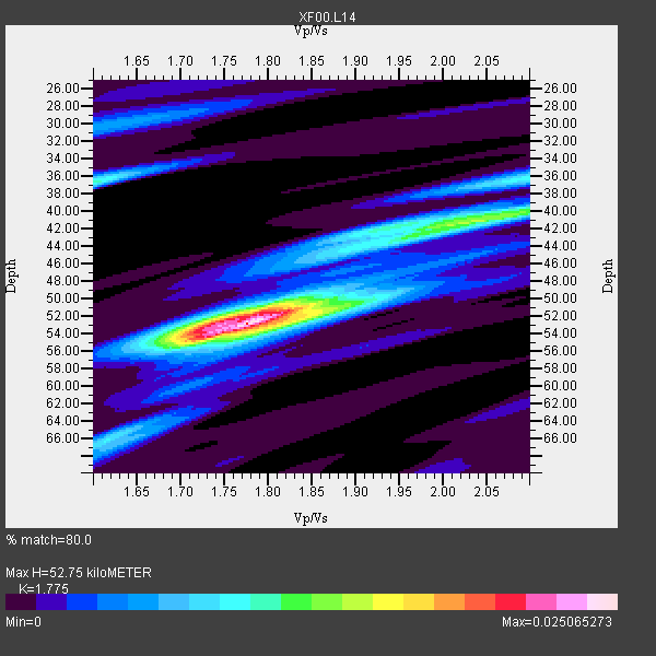
| Thickness Estimate: | 53 km |
| Thickness StdDev: | 6.1 km |
| Vp/Vs Estimate: | 1.77 |
| Vp/Vs StdDev: | 0.12 |
| Vs Estimate: | 3.553 km/s |
| Poisson's Ratio: | 0.27 |
| Peak Value: | 0.03 |
| Assumed Vp: | 6.306 km/s |
| Ps Weight: | 0.33333334 |
| PpPs Weight: | 0.33333334 |
| PsPs Weight: | 0.33333328 |
| Residual Complexity: | 0.594 |
| Nearby stations H: | +- |
| (2.0 deg) Vp/Vs: | +- |
3 with match > 90% ( 27.272728 %) and 11 with match > 80% ( 100.0 %) out of 11.
Download stack as xyz text file.
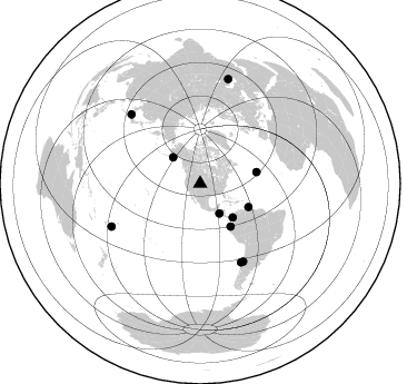
Azimuth Distribution of Events:
Prior Results for this Station
| Study | Thickness | Vp/Vs | Vp | Vs | Poissons Ratio | Extra |
| EARS | 53 km | 1.77 | 6.306 km/s | 3.553 km/s | 0.27 | |
| Crust2.0 | 50 km | 1.76 | 6.306 km/s | 3.584 km/s | 0.26 | P4,orogen/50km, Urals, Tethian Orogen, Rockies 1 km seds. |
| Global Maxima | 53 km | 1.77 | 6.306 km/s | 3.553 km/s | 0.27 | amp=0.025065273 |
| Local Maxima 1 | 41 km | 2.04 | 6.306 km/s | 3.087 km/s | 0.34 | amp=0.013102647 |
| Local Maxima 2 | 52 km | 1.74 | 6.306 km/s | 3.624 km/s | 0.25 | amp=0.012176528 |
| Local Maxima 3 | 36 km | 1.60 | 6.306 km/s | 3.935 km/s | 0.18 | amp=0.010582647 |
| Local Maxima 4 | 36 km | 2.09 | 6.306 km/s | 3.021 km/s | 0.35 | amp=0.007899764 |
| Predicted Arrivals for vertical incidence (zero ray parameter) | |
| Ps | 6.48 SECOND |
| PpPs | 23.21 SECOND |
| PsPs/PpSs | 29.70 SECOND |
Events Processed for this Station
Download zip of receiver functions as SAC
Plot maxima for each earthquake.
Events Used in the Stack
(11 events)| Radial Match | Distance | Baz | FERegion | Time | Lat/Lon | Depth | Magnitude |
| 94.408356 | 31.8 deg | 147.123 deg | El Salvador | 2001/01/13 17:33:32 GMT | (13.0, -88.7) | 60 km | 6.4 MB, 7.8 MS, 7.7 MW, 7.5 ME |
| 92.5351 | 79.5 deg | 152.445 deg | Off Coast Of Central Chile | 2001/04/09 09:00:57 GMT | (-32.7, -73.1) | 11 km | 6.1 MB, 6.3 MS, 6.7 MW, 6.3 ME |
| 91.35595 | 47.2 deg | 144.565 deg | Near Coast Of Ecuador | 2000/09/28 23:23:43 GMT | (-0.2, -80.6) | 23 km | 5.8 MB, 6.0 MS, 6.6 MW, 6.4 MW |
| 89.17999 | 42.2 deg | 136.194 deg | Panama-Colombia Border Region | 2000/11/08 06:59:58 GMT | (7.0, -77.8) | 17 km | 6.0 MB, 6.4 MS, 6.5 MW, 6.2 ML |
| 83.237915 | 97.6 deg | 15.059 deg | Turkmenistan | 2000/12/06 17:11:06 GMT | (39.6, 54.8) | 30 km | 6.7 MB, 7.5 MS, 7.0 MW, 6.9 ME |
| 82.35307 | 51.9 deg | 78.553 deg | Northern Mid-Atlantic Ridge | 2000/10/05 13:39:11 GMT | (31.7, -41.0) | 10 km | 5.4 MB, 6.1 MS, 6.0 MW, 5.9 MW |
| 82.218765 | 88.4 deg | 244.279 deg | Fiji Islands Region | 2001/04/28 04:49:53 GMT | (-18.1, -176.9) | 352 km | 6.2 MB, 6.8 MW, 6.8 MW |
| 82.12427 | 34.0 deg | 314.035 deg | Kodiak Island Region, Alaska | 2001/01/10 16:02:44 GMT | (57.1, -153.2) | 33 km | 6.2 MB, 6.8 MS, 7.1 MW, 6.8 ML |
| 82.094505 | 48.3 deg | 115.867 deg | Windward Islands | 2000/10/04 14:37:44 GMT | (11.1, -62.6) | 110 km | 5.6 MB, 5.4 MS, 6.1 MW, 5.9 MD |
| 81.80015 | 87.9 deg | 315.058 deg | Western Honshu, Japan | 2001/03/24 06:27:53 GMT | (34.1, 132.5) | 50 km | 6.4 MB, 6.5 MS, 6.8 MW, 6.4 ME |
| 81.23068 | 79.7 deg | 151.037 deg | Near Coast Of Central Chile | 2001/03/15 13:02:42 GMT | (-32.3, -71.5) | 37 km | 6.1 MB, 5.6 MS, 6.0 MW, 5.4 MD |
Losers
(0 events)| Radial Match | Distance | Baz | FERegion | Time | Lat/Lon | Depth | Magnitude | Reason |
