
Station XJ OSO - Ossora
Network: XJ98 - Side Edge of Kamchatka Subduction Zone
Nearby stations (2 deg radius)
| Station | Name | (Lat, Lon) | Start / End | Elevation |
| OSO | Ossora | (59.26, 163.08) | 1998-10-29 / 1999-12-31 | 47 m |
| Crust2 Type: | T6,Margin /shield transition, 1 km seds. |
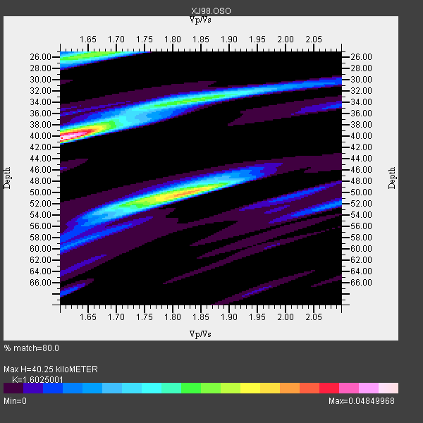
| Thickness Estimate: | 40 km |
| Thickness StdDev: | 3.6 km |
| Vp/Vs Estimate: | 1.60 |
| Vp/Vs StdDev: | 0.16 |
| Vs Estimate: | 4.039 km/s |
| Poisson's Ratio: | 0.18 |
| Peak Value: | 0.05 |
| Assumed Vp: | 6.472 km/s |
| Ps Weight: | 0.33333334 |
| PpPs Weight: | 0.33333334 |
| PsPs Weight: | 0.33333328 |
| Residual Complexity: | 0.825 |
| Nearby stations H: | +- |
| (2.0 deg) Vp/Vs: | +- |
1 with match > 90% ( 7.6923075 %) and 2 with match > 80% ( 15.384615 %) out of 13.
Download stack as xyz text file.
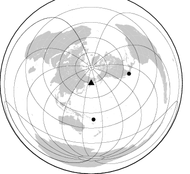
Azimuth Distribution of Events:
Prior Results for this Station
| Study | Thickness | Vp/Vs | Vp | Vs | Poissons Ratio | Extra |
| EARS | 40 km | 1.60 | 6.472 km/s | 4.039 km/s | 0.18 | |
| Crust2.0 | 32 km | 1.79 | 6.472 km/s | 3.622 km/s | 0.27 | T6,Margin /shield transition, 1 km seds. |
| Global Maxima | 40 km | 1.60 | 6.472 km/s | 4.039 km/s | 0.18 | amp=0.04849968 |
| Local Maxima 1 | 50 km | 1.83 | 6.472 km/s | 3.546 km/s | 0.29 | amp=0.035302036 |
| Local Maxima 2 | 26 km | 1.65 | 6.472 km/s | 3.916 km/s | 0.21 | amp=0.026664574 |
| Local Maxima 3 | 34 km | 1.84 | 6.472 km/s | 3.517 km/s | 0.29 | amp=0.024531495 |
| Local Maxima 4 | 38 km | 1.66 | 6.472 km/s | 3.893 km/s | 0.22 | amp=0.017125687 |
| Predicted Arrivals for vertical incidence (zero ray parameter) | |
| Ps | 3.75 SECOND |
| PpPs | 16.19 SECOND |
| PsPs/PpSs | 19.93 SECOND |
Events Processed for this Station
Download zip of receiver functions as SAC
Plot maxima for each earthquake.
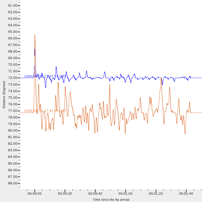
Events Used in the Stack
(2 events)| Radial Match | Distance | Baz | FERegion | Time | Lat/Lon | Depth | Magnitude |
| 96.4865 | 71.9 deg | 176.293 deg | Santa Cruz Islands | 1999/02/06 21:47:59 GMT | (-12.9, 166.7) | 90 km | 6.3 MB, 7.3 MS, 7.4 MW, 7.0 ME |
| 83.08435 | 77.2 deg | 75.938 deg | Guerrero, Mexico | 1999/06/21 17:43:04 GMT | (18.3, -101.5) | 69 km | 6.0 MB, 5.8 MS, 6.3 MW, 5.8 MD |
Losers
(11 events)| Radial Match | Distance | Baz | FERegion | Time | Lat/Lon | Depth | Magnitude | Reason |
| 78.930374 | 64.1 deg | 190.458 deg | New Ireland Region, P.N.G. | 1999/01/28 18:24:25 GMT | (-4.6, 153.7) | 101 km | 5.6 MB, 6.4 MW, 6.3 MW | |
| 78.57969 | 35.9 deg | 231.224 deg | Kyushu, Japan | 1999/01/24 00:37:04 GMT | (30.6, 131.1) | 33 km | 6.1 MB, 6.1 MS, 6.4 MW, 6.4 MW | |
| 69.99575 | 60.4 deg | 222.826 deg | Mindanao, Philippines | 1999/06/18 10:55:25 GMT | (5.5, 126.6) | 33 km | 6.1 MB, 6.1 MS, 6.4 MW, 6.4 MW | |
| 64.855225 | 77.9 deg | 174.023 deg | Vanuatu Islands | 1999/01/29 15:04:29 GMT | (-18.7, 169.3) | 237 km | 5.5 MW, 5.3 MB | |
| 62.65606 | 86.2 deg | 69.201 deg | Near Coast Of Guatemala | 1999/06/06 07:08:05 GMT | (13.9, -90.8) | 33 km | 5.5 MB, 5.9 MS, 6.3 MW, 5.8 MD | |
| 61.248573 | 50.0 deg | 235.298 deg | Philippine Islands Region | 1999/02/06 17:45:24 GMT | (19.2, 121.3) | 33 km | 5.6 MS, 5.4 MB, 6.0 MW, 5.9 MW | |
| 60.43757 | 66.6 deg | 223.976 deg | Minahassa Peninsula, Sulawesi | 1999/06/02 00:23:19 GMT | (0.1, 123.5) | 161 km | 5.8 MB, 5.6 MW | |
| 58.720146 | 75.3 deg | 252.71 deg | Northern Sumatra, Indonesia | 1999/02/04 19:28:00 GMT | (4.0, 95.3) | 56 km | 5.8 MB, 5.4 MS, 5.9 MW, 5.9 MW | |
| 57.92526 | 74.6 deg | 175.089 deg | Vanuatu Islands | 1999/02/14 21:12:24 GMT | (-15.5, 168.0) | 10 km | 5.9 MB, 5.5 MS, 6.0 MW, 6.0 MW | |
| 56.92547 | 78.4 deg | 157.031 deg | Tonga Islands | 1999/06/16 18:35:59 GMT | (-17.0, -173.4) | 75 km | 5.6 MB, 5.2 MS, 5.9 MW, 5.8 MW | |
| 51.0591 | 98.0 deg | 42.193 deg | Leeward Islands | 1999/06/08 12:04:00 GMT | (15.0, -60.4) | 55 km | 5.8 MW, 5.3 MS, 5.3 MB, 5.8 MW |
