
Station XJ TIG - Tigil
Network: XJ98 - Side Edge of Kamchatka Subduction Zone
Nearby stations (2 deg radius)
| Station | Name | (Lat, Lon) | Start / End | Elevation |
| TIG | Tigil | (57.76, 158.69) | 1998-10-04 / 1999-12-31 | 47 m |
| Crust2 Type: | L2,thin continental arc, Mexico, 2 km seds. |
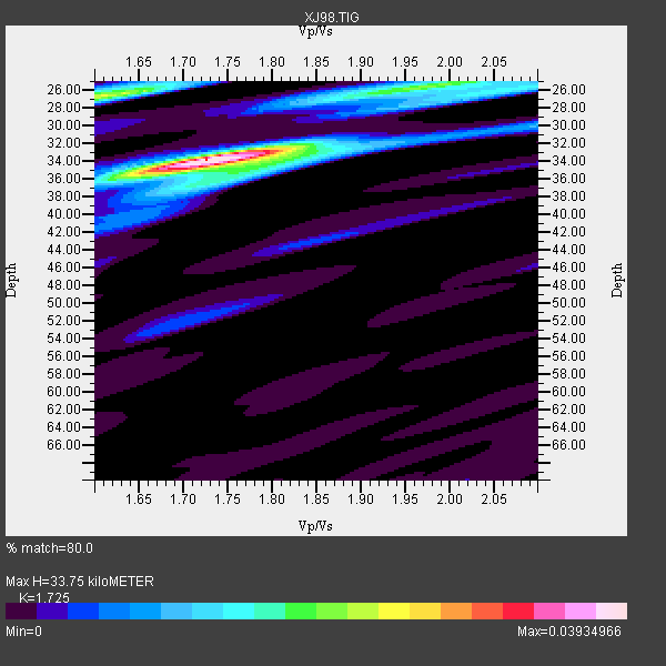
| Thickness Estimate: | 34 km |
| Thickness StdDev: | 3.6 km |
| Vp/Vs Estimate: | 1.73 |
| Vp/Vs StdDev: | 0.11 |
| Vs Estimate: | 3.732 km/s |
| Poisson's Ratio: | 0.25 |
| Peak Value: | 0.04 |
| Assumed Vp: | 6.438 km/s |
| Ps Weight: | 0.33333334 |
| PpPs Weight: | 0.33333334 |
| PsPs Weight: | 0.33333328 |
| Residual Complexity: | 0.548 |
| Nearby stations H: | +- |
| (2.0 deg) Vp/Vs: | +- |
2 with match > 90% ( 13.333333 %) and 8 with match > 80% ( 53.333332 %) out of 15.
Download stack as xyz text file.
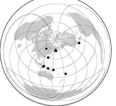
Azimuth Distribution of Events:
Prior Results for this Station
| Study | Thickness | Vp/Vs | Vp | Vs | Poissons Ratio | Extra |
| EARS | 34 km | 1.73 | 6.438 km/s | 3.732 km/s | 0.25 | |
| Crust2.0 | 34 km | 1.78 | 6.438 km/s | 3.624 km/s | 0.27 | L2,thin continental arc, Mexico, 2 km seds. |
| Global Maxima | 34 km | 1.73 | 6.438 km/s | 3.732 km/s | 0.25 | amp=0.03934966 |
| Local Maxima 1 | 26 km | 1.61 | 6.438 km/s | 3.999 km/s | 0.19 | amp=0.024710238 |
| Local Maxima 2 | 26 km | 1.98 | 6.438 km/s | 3.26 km/s | 0.33 | amp=0.018943727 |
| Local Maxima 3 | 34 km | 1.79 | 6.438 km/s | 3.592 km/s | 0.27 | amp=0.013875275 |
| Local Maxima 4 | 26 km | 2.06 | 6.438 km/s | 3.122 km/s | 0.35 | amp=0.011112077 |
| Predicted Arrivals for vertical incidence (zero ray parameter) | |
| Ps | 3.80 SECOND |
| PpPs | 14.28 SECOND |
| PsPs/PpSs | 18.09 SECOND |
Events Processed for this Station
Download zip of receiver functions as SAC
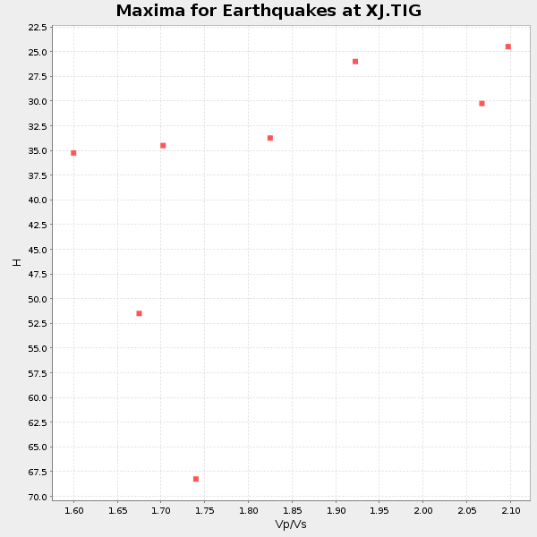
Plot maxima for each earthquake.
Events Used in the Stack
(8 events)| Radial Match | Distance | Baz | FERegion | Time | Lat/Lon | Depth | Magnitude |
| 94.7117 | 65.5 deg | 217.656 deg | Ceram Sea | 1998/11/29 14:10:31 GMT | (-2.1, 124.9) | 33 km | 6.5 MB, 7.7 MS, 8.1 UNKNOWN, 7.8 MW |
| 92.48859 | 33.1 deg | 226.935 deg | Kyushu, Japan | 1999/01/24 00:37:04 GMT | (30.6, 131.1) | 33 km | 6.1 MB, 6.1 MS, 6.4 MW, 6.4 MW |
| 89.977905 | 81.8 deg | 156.649 deg | Fiji Islands Region | 1998/12/27 00:38:26 GMT | (-21.6, -176.4) | 144 km | 6.1 MB, 6.9 UNKNOWN, 6.6 ME |
| 88.66761 | 62.4 deg | 203.211 deg | Irian Jaya, Indonesia | 1999/05/16 15:25:53 GMT | (-2.6, 138.2) | 59 km | 6.1 MB, 6.2 MS, 6.4 MW, 6.4 ME |
| 88.343605 | 62.9 deg | 186.502 deg | New Britain Region, P.N.G. | 1999/05/17 10:07:56 GMT | (-5.2, 152.9) | 27 km | 5.5 MB, 6.9 MS, 6.7 MW, 6.0 ME |
| 86.150635 | 62.4 deg | 217.578 deg | Northern Molucca Sea | 1998/10/28 16:25:03 GMT | (0.8, 126.0) | 33 km | 6.2 MB, 6.2 MS, 6.6 UNKNOWN, 6.6 MW |
| 81.52537 | 31.0 deg | 282.135 deg | Lake Baykal Region, Russia | 1999/02/25 18:58:29 GMT | (51.6, 104.9) | 10 km | 5.9 MB, 5.5 MS, 6.1 MW, 6.1 MW |
| 80.307594 | 79.8 deg | 72.028 deg | Guerrero, Mexico | 1999/06/21 17:43:04 GMT | (18.3, -101.5) | 69 km | 6.0 MB, 5.8 MS, 6.3 MW, 5.8 MD |
Losers
(7 events)| Radial Match | Distance | Baz | FERegion | Time | Lat/Lon | Depth | Magnitude | Reason |
| 68.48335 | 65.4 deg | 180.069 deg | Solomon Islands | 1998/11/25 18:05:25 GMT | (-7.9, 158.6) | 48 km | 5.9 MB, 6.0 MS, 6.2 UNKNOWN, 6.2 MW | |
| 64.07806 | 80.7 deg | 159.037 deg | Fiji Islands Region | 1998/10/11 12:04:54 GMT | (-21.0, -179.1) | 624 km | 5.9 UNKNOWN, 5.4 MB, 5.9 MW | |
| 62.76615 | 62.5 deg | 186.969 deg | New Britain Region, P.N.G. | 1999/05/16 00:51:20 GMT | (-4.8, 152.5) | 74 km | 6.0 MB, 7.0 MS, 7.1 MW, 6.3 ME | |
| 53.91778 | 81.7 deg | 156.756 deg | Fiji Islands Region | 1998/11/15 02:44:12 GMT | (-21.6, -176.5) | 149 km | 5.9 MB, 6.3 UNKNOWN, 6.2 MW | |
| 53.264584 | 75.5 deg | 158.567 deg | Fiji Islands Region | 1999/01/29 01:09:16 GMT | (-15.9, -179.7) | 33 km | 5.7 MS, 5.3 MB, 5.9 MW, 5.9 MW | |
| 49.26495 | 72.5 deg | 218.889 deg | Flores Region, Indonesia | 1998/12/07 23:37:06 GMT | (-8.3, 121.4) | 33 km | 5.5 MB, 5.4 MS, 5.9 UNKNOWN, 5.8 MW | |
| 27.35697 | 88.9 deg | 65.435 deg | Near Coast Of Guatemala | 1999/06/06 07:08:05 GMT | (13.9, -90.8) | 33 km | 5.5 MB, 5.9 MS, 6.3 MW, 5.8 MD |
