
Station XK STOR - Point of Stoer
Network: XK01 - Reflections under the Scottish Highlands
Nearby stations (2 deg radius)
| Station | Name | (Lat, Lon) | Start / End | Elevation |
| STOR | Point of Stoer | (58.24, -5.38) | 2001-07-07 / 2003-12-31 | 0.1 km |
| Crust2 Type: | C2,continental shelf, 1 km seds. |
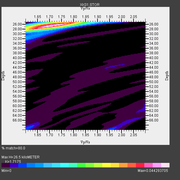
| Thickness Estimate: | 26 km |
| Thickness StdDev: | 0.4 km |
| Vp/Vs Estimate: | 1.72 |
| Vp/Vs StdDev: | 0.02 |
| Vs Estimate: | 3.633 km/s |
| Poisson's Ratio: | 0.24 |
| Peak Value: | 0.04 |
| Assumed Vp: | 6.24 km/s |
| Ps Weight: | 0.33333334 |
| PpPs Weight: | 0.33333334 |
| PsPs Weight: | 0.33333328 |
| Residual Complexity: | 0.305 |
| Nearby stations H: | +- |
| (2.0 deg) Vp/Vs: | +- |
4 with match > 90% ( 44.444443 %) and 9 with match > 80% ( 100.0 %) out of 9.
Download stack as xyz text file.
Azimuth Distribution of Events:
Prior Results for this Station
| Study | Thickness | Vp/Vs | Vp | Vs | Poissons Ratio | Extra |
| EARS | 26 km | 1.72 | 6.24 km/s | 3.633 km/s | 0.24 | |
| Crust2.0 | 30 km | 1.80 | 6.24 km/s | 3.467 km/s | 0.28 | C2,continental shelf, 1 km seds. |
| Global Maxima | 26 km | 1.72 | 6.24 km/s | 3.633 km/s | 0.24 | amp=0.044293705 |
| Local Maxima 1 | 26 km | 1.68 | 6.24 km/s | 3.709 km/s | 0.23 | amp=0.020264208 |
| Local Maxima 2 | 70 km | 1.60 | 6.24 km/s | 3.9 km/s | 0.18 | amp=0.005438791 |
| Local Maxima 3 | 70 km | 1.95 | 6.24 km/s | 3.208 km/s | 0.32 | amp=0.004345771 |
| Local Maxima 4 | 32 km | 1.61 | 6.24 km/s | 3.882 km/s | 0.18 | amp=0.003908235 |
| Predicted Arrivals for vertical incidence (zero ray parameter) | |
| Ps | 3.05 SECOND |
| PpPs | 11.54 SECOND |
| PsPs/PpSs | 14.59 SECOND |
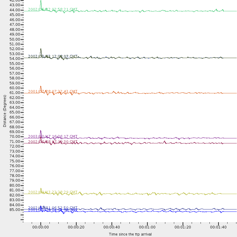
Events Processed for this Station
Download zip of receiver functions as SAC
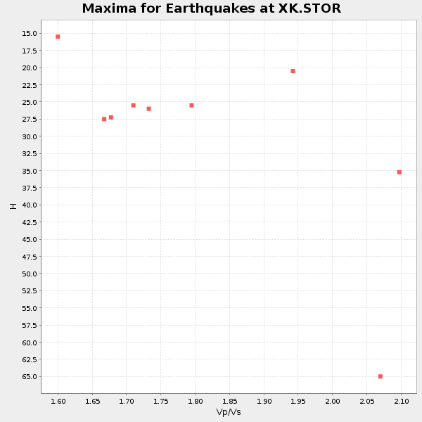
Plot maxima for each earthquake.
Events Used in the Stack
(9 events)| Radial Match | Distance | Baz | FERegion | Time | Lat/Lon | Depth | Magnitude |
| 95.33977 | 52.6 deg | 79.4 deg | Hindu Kush Region, Afghanistan | 2002/03/03 12:08:19 GMT | (36.5, 70.5) | 226 km | 6.6 MB, 7.4 MW, 7.3 MW |
| 95.3129 | 70.8 deg | 357.771 deg | Rat Islands, Aleutian Islands | 2003/03/17 16:36:17 GMT | (51.3, 178.0) | 33 km | 5.9 MB, 6.7 MS, 7.0 MW, 7.0 MW |
| 95.248604 | 52.7 deg | 79.493 deg | Hindu Kush Region, Afghanistan | 2002/03/03 12:08:07 GMT | (36.4, 70.4) | 209 km | 6.3 MB |
| 91.4762 | 72.0 deg | 31.929 deg | E. Russia-N.E. China Border Reg. | 2002/06/28 17:19:30 GMT | (43.8, 130.7) | 566 km | 6.7 MB, 7.3 MW, 7.3 MW |
| 88.583466 | 42.0 deg | 98.201 deg | Western Iran | 2002/06/22 02:58:21 GMT | (35.6, 49.0) | 10 km | 6.2 MB, 6.4 MS, 6.5 MW, 6.5 MW |
| 86.85333 | 87.5 deg | 46.1 deg | Taiwan Region | 2001/12/18 04:02:58 GMT | (24.0, 122.7) | 14 km | 6.3 MB, 7.3 MS, 6.9 MW, 6.8 MW |
| 86.72675 | 87.0 deg | 46.426 deg | Taiwan Region | 2002/03/31 06:52:50 GMT | (24.3, 122.2) | 33 km | 6.4 MB, 7.4 MS, 7.1 MW, 7.1 MW |
| 86.42547 | 60.7 deg | 342.604 deg | Southern Alaska | 2001/07/28 07:32:43 GMT | (59.0, -155.1) | 131 km | 5.7 MB, 5.7 MS, 6.6 MW, 6.2 ME |
| 82.436165 | 83.4 deg | 76.02 deg | Andaman Islands, India Region | 2002/09/13 22:28:29 GMT | (13.0, 93.1) | 21 km | 6.2 MB, 6.7 MS, 6.5 MW, 6.5 MW |
Losers
(0 events)| Radial Match | Distance | Baz | FERegion | Time | Lat/Lon | Depth | Magnitude | Reason |
