
Station XK 5110 - twist97_5110
Network: XK97 - Western Superior Teleseismic Experiment
Nearby stations (2 deg radius)
| Station | Name | (Lat, Lon) | Start / End | Elevation |
| 5110 | twist97_5110 | (50.02, -90.59) | 1997-05-15 / 1997-12-31 | 408 m |
| Crust2 Type: | G1,Archean, no seds. |
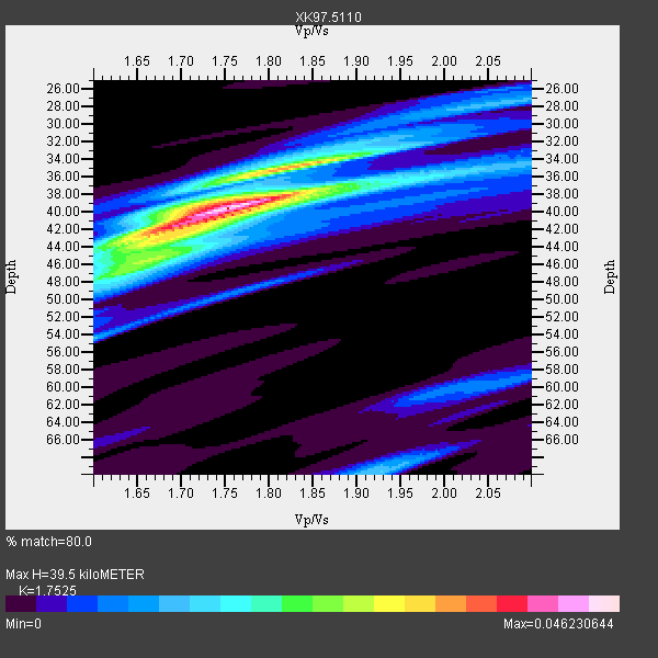
| Thickness Estimate: | 40 km |
| Thickness StdDev: | 2.5 km |
| Vp/Vs Estimate: | 1.75 |
| Vp/Vs StdDev: | 0.05 |
| Vs Estimate: | 3.686 km/s |
| Poisson's Ratio: | 0.26 |
| Peak Value: | 0.05 |
| Assumed Vp: | 6.459 km/s |
| Ps Weight: | 0.33333334 |
| PpPs Weight: | 0.33333334 |
| PsPs Weight: | 0.33333328 |
| Residual Complexity: | 0.580 |
| Nearby stations H: | +- |
| (2.0 deg) Vp/Vs: | +- |
5 with match > 90% ( 38.46154 %) and 6 with match > 80% ( 46.153847 %) out of 13.
Download stack as xyz text file.
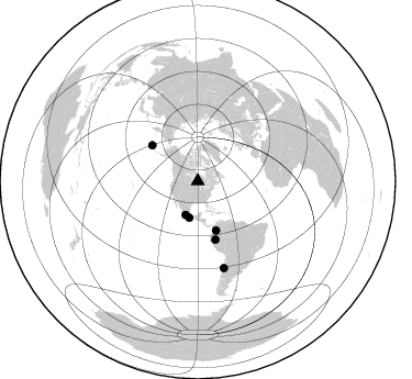
Azimuth Distribution of Events:
Prior Results for this Station
| Study | Thickness | Vp/Vs | Vp | Vs | Poissons Ratio | Extra |
| EARS | 40 km | 1.75 | 6.459 km/s | 3.686 km/s | 0.26 | |
| Crust2.0 | 37 km | 1.76 | 6.459 km/s | 3.665 km/s | 0.26 | G1,Archean, no seds. |
| Global Maxima | 40 km | 1.75 | 6.459 km/s | 3.686 km/s | 0.26 | amp=0.046230644 |
| Local Maxima 1 | 42 km | 1.67 | 6.459 km/s | 3.862 km/s | 0.22 | amp=0.027038433 |
| Local Maxima 2 | 35 km | 1.83 | 6.459 km/s | 3.535 km/s | 0.29 | amp=0.025550826 |
| Local Maxima 3 | 70 km | 1.93 | 6.459 km/s | 3.351 km/s | 0.32 | amp=0.013955846 |
| Local Maxima 4 | 54 km | 1.60 | 6.459 km/s | 4.037 km/s | 0.18 | amp=0.012366551 |
| Predicted Arrivals for vertical incidence (zero ray parameter) | |
| Ps | 4.60 SECOND |
| PpPs | 16.83 SECOND |
| PsPs/PpSs | 21.43 SECOND |
Events Processed for this Station
Download zip of receiver functions as SAC
Plot maxima for each earthquake.
Events Used in the Stack
(6 events)| Radial Match | Distance | Baz | FERegion | Time | Lat/Lon | Depth | Magnitude |
| 95.667816 | 55.5 deg | 163.092 deg | Northern Peru | 1997/10/28 06:15:17 GMT | (-4.4, -76.7) | 112 km | 6.6 MB, 6.3 MS, 7.2 UNKNOWN, 6.6 ME |
| 94.86363 | 34.2 deg | 193.12 deg | Near Coast Of Guerrero, Mexico | 1997/07/19 14:22:08 GMT | (16.3, -98.2) | 33 km | 5.7 MB, 6.3 MS, 6.8 UNKNOWN, 6.0 ME |
| 93.730896 | 82.4 deg | 163.293 deg | Near Coast Of Central Chile | 1997/10/15 01:03:33 GMT | (-30.9, -71.2) | 58 km | 6.8 MB, 6.8 MS, 7.3 UNKNOWN, 7.1 MW |
| 93.41112 | 32.5 deg | 199.712 deg | Guerrero, Mexico | 1997/05/22 07:50:53 GMT | (18.7, -101.6) | 70 km | 5.9 MB, 6.0 MS, 6.6 UNKNOWN, 6.5 MW |
| 91.768326 | 47.7 deg | 159.786 deg | Colombia | 1997/09/02 12:13:22 GMT | (3.8, -75.7) | 199 km | 6.5 MB, 6.8 UNKNOWN, 6.4 ME |
| 87.48736 | 52.8 deg | 308.118 deg | Andreanof Islands, Aleutian Is. | 1997/06/17 21:03:40 GMT | (51.3, -179.3) | 33 km | 6.4 MB, 6.3 MS, 6.4 UNKNOWN, 6.6 ML |
Losers
(7 events)| Radial Match | Distance | Baz | FERegion | Time | Lat/Lon | Depth | Magnitude | Reason |
| 76.84283 | 75.5 deg | 50.29 deg | Southern Greece | 1997/10/13 13:39:37 GMT | (36.4, 22.1) | 24 km | 6.2 MB, 6.6 MS, 6.7 UNKNOWN, 6.5 MW | |
| 74.57863 | 81.8 deg | 163.775 deg | Near Coast Of Central Chile | 1997/07/25 06:47:02 GMT | (-30.5, -71.9) | 33 km | 5.6 MB, 5.5 MS, 6.3 UNKNOWN | |
| 70.44957 | 75.8 deg | 156.985 deg | Jujuy Province, Argentina | 1997/07/20 10:14:22 GMT | (-23.0, -66.3) | 256 km | 5.7 MB, 6.1 UNKNOWN, 5.7 ME | |
| 61.982353 | 81.7 deg | 163.756 deg | Near Coast Of Central Chile | 1997/07/21 23:19:39 GMT | (-30.3, -71.9) | 33 km | 5.2 MB, 5.5 MS, 6.1 UNKNOWN | |
| 56.61568 | 96.9 deg | 254.731 deg | Tonga Islands | 1997/05/27 08:00:29 GMT | (-15.2, -173.3) | 14 km | 5.6 MB, 6.3 MS, 6.4 UNKNOWN, 5.7 ME | |
| 54.500687 | 52.4 deg | 307.798 deg | Andreanof Islands, Aleutian Is. | 1997/07/08 12:11:15 GMT | (51.4, -178.6) | 33 km | 5.5 MB, 5.4 MS, 5.8 UNKNOWN, 5.6 ML | |
| 48.381954 | 92.7 deg | 312.69 deg | Volcano Islands, Japan Region | 1997/07/08 02:24:07 GMT | (23.8, 142.7) | 33 km | 5.8 MB, 5.6 MS, 5.9 UNKNOWN, 5.8 MW |
