
Station XK N24 - North 24
Network: XK99 - CDROM (Colorado)
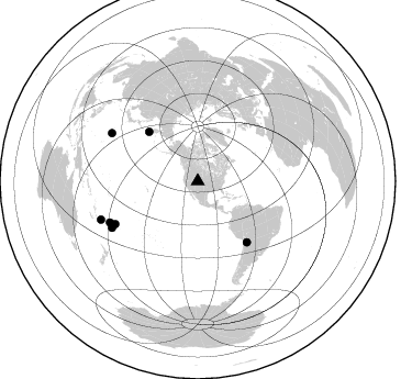
Nearby stations (2 deg radius)
| Station | Name | (Lat, Lon) | Start / End | Elevation |
| N24 | North 24 | (40.21, -106.78) | 1999-06-07 / 2000-12-31 | 2421 m |
| Crust2 Type: | P1,orogen/46km, Urals, Tethian Orogen, 2 km seds. |
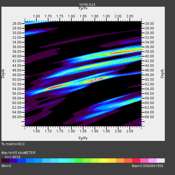
| Thickness Estimate: | 50 km |
| Thickness StdDev: | 6.9 km |
| Vp/Vs Estimate: | 1.90 |
| Vp/Vs StdDev: | 0.12 |
| Vs Estimate: | 3.237 km/s |
| Poisson's Ratio: | 0.31 |
| Peak Value: | 0.01 |
| Assumed Vp: | 6.159 km/s |
| Ps Weight: | 0.33333334 |
| PpPs Weight: | 0.33333334 |
| PsPs Weight: | 0.33333328 |
| Residual Complexity: | 0.821 |
| Nearby stations H: | +- |
| (2.0 deg) Vp/Vs: | +- |
3 with match > 90% ( 42.857143 %) and 7 with match > 80% ( 100.0 %) out of 7.
Download stack as xyz text file.
Azimuth Distribution of Events:
Prior Results for this Station
| Study | Thickness | Vp/Vs | Vp | Vs | Poissons Ratio | Extra |
| EARS | 50 km | 1.90 | 6.159 km/s | 3.237 km/s | 0.31 | |
| Crust2.0 | 46 km | 1.76 | 6.159 km/s | 3.507 km/s | 0.26 | P1,orogen/46km, Urals, Tethian Orogen, 2 km seds. |
| Global Maxima | 50 km | 1.90 | 6.159 km/s | 3.237 km/s | 0.31 | amp=0.0064841956 |
| Local Maxima 1 | 38 km | 1.99 | 6.159 km/s | 3.103 km/s | 0.33 | amp=0.0053344625 |
| Local Maxima 2 | 53 km | 1.73 | 6.159 km/s | 3.57 km/s | 0.25 | amp=0.003863184 |
| Local Maxima 3 | 59 km | 2.05 | 6.159 km/s | 3.008 km/s | 0.34 | amp=0.0033095186 |
| Local Maxima 4 | 43 km | 1.95 | 6.159 km/s | 3.162 km/s | 0.32 | amp=0.0032422445 |
| Predicted Arrivals for vertical incidence (zero ray parameter) | |
| Ps | 7.33 SECOND |
| PpPs | 23.56 SECOND |
| PsPs/PpSs | 30.89 SECOND |
Events Processed for this Station
Download zip of receiver functions as SAC
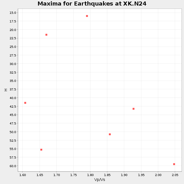
Plot maxima for each earthquake.
Events Used in the Stack
(7 events)| Radial Match | Distance | Baz | FERegion | Time | Lat/Lon | Depth | Magnitude |
| 97.809586 | 89.6 deg | 299.214 deg | Volcano Islands, Japan Region | 2000/03/28 11:00:22 GMT | (22.3, 143.7) | 126 km | 6.8 MB, 7.6 MS, 7.6 MW, 7.6 MW |
| 93.2875 | 84.6 deg | 242.645 deg | Tonga Islands | 2000/01/08 16:47:20 GMT | (-16.9, -174.2) | 183 km | 6.5 MB, 6.6 MS, 7.2 MW, 7.0 ME |
| 91.35517 | 94.6 deg | 248.458 deg | Vanuatu Islands Region | 2000/02/25 01:43:58 GMT | (-19.5, 173.8) | 33 km | 6.1 MB, 7.1 MS, 7.1 MW, 7.0 MW |
| 89.6861 | 88.7 deg | 241.459 deg | Fiji Islands Region | 2000/04/18 17:28:12 GMT | (-20.7, -176.5) | 221 km | 5.6 MB, 6.0 MW, 5.9 MW |
| 89.31544 | 88.2 deg | 244.777 deg | Fiji Islands Region | 2000/05/04 20:36:32 GMT | (-17.9, -178.5) | 516 km | 5.6 MB, 6.5 MW, 6.4 MW |
| 87.08817 | 71.1 deg | 141.059 deg | Southern Bolivia | 1999/09/15 03:01:24 GMT | (-20.9, -67.3) | 218 km | 6.0 MB, 6.4 MW, 6.4 MW |
| 83.564476 | 63.1 deg | 315.421 deg | Near East Coast Of Kamchatka | 1999/09/18 21:28:33 GMT | (51.2, 157.6) | 60 km | 5.9 MB, 5.6 MS, 6.2 MW, 6.0 MW |
Losers
(0 events)| Radial Match | Distance | Baz | FERegion | Time | Lat/Lon | Depth | Magnitude | Reason |
