
Station XL S129 - Philadephia Creek
Network: XL97 - Deep Probe (Archean-Proterozoic)
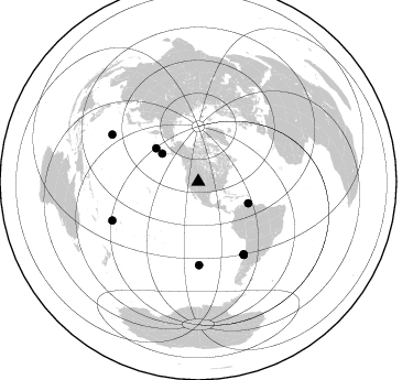
Nearby stations (2 deg radius)
| Station | Name | (Lat, Lon) | Start / End | Elevation |
| S129 | Philadephia Creek | (39.91, -108.68) | 1997-05-09 / 1997-12-31 | 1929 m |
| Crust2 Type: | Q3,orogen/43km no ice, Appalachians, 3 km seds. |
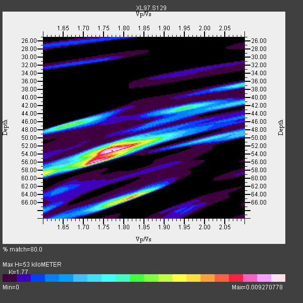
| Thickness Estimate: | 53 km |
| Thickness StdDev: | 5.3 km |
| Vp/Vs Estimate: | 1.77 |
| Vp/Vs StdDev: | 0.10 |
| Vs Estimate: | 3.554 km/s |
| Poisson's Ratio: | 0.27 |
| Peak Value: | 0.01 |
| Assumed Vp: | 6.291 km/s |
| Ps Weight: | 0.33333334 |
| PpPs Weight: | 0.33333334 |
| PsPs Weight: | 0.33333328 |
| Residual Complexity: | 0.670 |
| Nearby stations H: | +- |
| (2.0 deg) Vp/Vs: | +- |
4 with match > 90% ( 16.0 %) and 9 with match > 80% ( 36.0 %) out of 25.
Download stack as xyz text file.
Azimuth Distribution of Events:
Prior Results for this Station
| Study | Thickness | Vp/Vs | Vp | Vs | Poissons Ratio | Extra |
| EARS | 53 km | 1.77 | 6.291 km/s | 3.554 km/s | 0.27 | |
| Crust2.0 | 43 km | 1.76 | 6.291 km/s | 3.577 km/s | 0.26 | Q3,orogen/43km no ice, Appalachians, 3 km seds. |
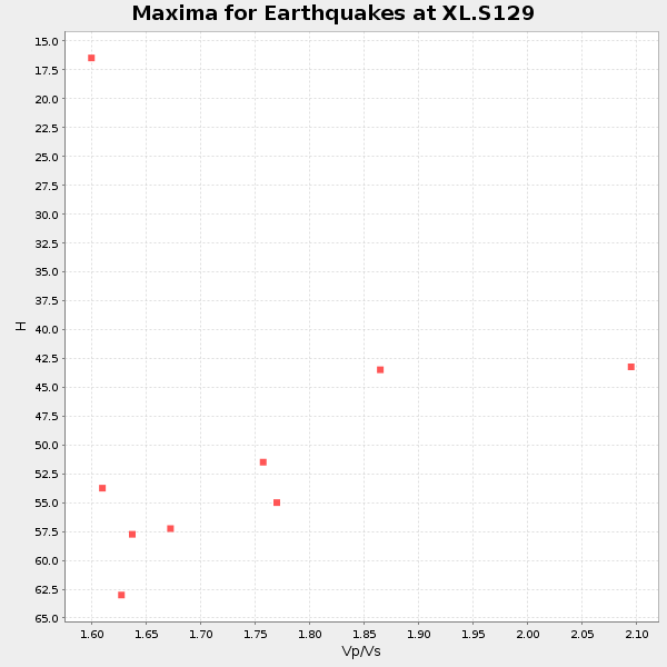
| Global Maxima | 53 km | 1.77 | 6.291 km/s | 3.554 km/s | 0.27 | amp=0.009270778 |
| Local Maxima 1 | 65 km | 1.81 | 6.291 km/s | 3.471 km/s | 0.28 | amp=0.0072238273 |
| Local Maxima 2 | 56 km | 1.73 | 6.291 km/s | 3.642 km/s | 0.25 | amp=0.0068304464 |
| Local Maxima 3 | 46 km | 1.67 | 6.291 km/s | 3.767 km/s | 0.22 | amp=0.004827816 |
| Local Maxima 4 | 59 km | 1.60 | 6.291 km/s | 3.932 km/s | 0.18 | amp=0.004582021 |
| Predicted Arrivals for vertical incidence (zero ray parameter) | |
| Ps | 6.49 SECOND |
| PpPs | 23.34 SECOND |
| PsPs/PpSs | 29.82 SECOND |
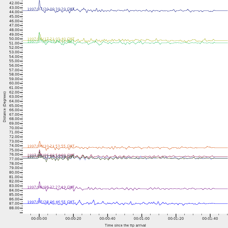
Events Processed for this Station
Download zip of receiver functions as SAC
Plot maxima for each earthquake.
Events Used in the Stack
(9 events)| Radial Match | Distance | Baz | FERegion | Time | Lat/Lon | Depth | Magnitude |
| 92.536606 | 49.5 deg | 113.424 deg | Near Coast Of Venezuela | 1997/07/09 19:24:13 GMT | (10.6, -63.5) | 20 km | 6.2 MB, 6.8 MS, 7.0 UNKNOWN, 6.6 ME |
| 92.12018 | 77.6 deg | 147.863 deg | Near Coast Of Central Chile | 1997/07/06 09:54:00 GMT | (-30.1, -71.9) | 19 km | 5.8 MB, 6.5 MS, 6.8 UNKNOWN, 6.4 ME |
| 91.2654 | 75.4 deg | 179.54 deg | Southern East Pacific Rise | 1997/06/10 21:53:55 GMT | (-35.8, -108.1) | 10 km | 5.8 MB, 6.1 MS, 6.5 UNKNOWN, 5.8 MS |
| 90.223145 | 41.5 deg | 307.94 deg | Fox Islands, Aleutian Islands | 1997/07/20 00:30:20 GMT | (52.6, -167.5) | 14 km | 5.6 MB, 5.9 MS, 6.2 UNKNOWN, 6.2 MW |
| 88.83195 | 78.0 deg | 148.076 deg | Near Coast Of Central Chile | 1997/07/27 05:21:29 GMT | (-30.5, -71.9) | 33 km | 5.6 MB, 5.8 MS, 6.3 UNKNOWN, 6.2 MW |
| 86.06872 | 85.5 deg | 245.71 deg | Fiji Islands Region | 1997/08/08 22:27:19 GMT | (-15.5, -179.1) | 10 km | 5.7 MB, 6.6 MS, 6.6 UNKNOWN, 6.4 MW |
| 83.90256 | 77.9 deg | 148.084 deg | Near Coast Of Central Chile | 1997/07/25 06:47:02 GMT | (-30.5, -71.9) | 33 km | 5.6 MB, 5.5 MS, 6.3 UNKNOWN |
| 82.60566 | 89.2 deg | 298.652 deg | Volcano Islands, Japan Region | 1997/07/28 06:46:55 GMT | (22.4, 142.7) | 33 km | 5.7 MB, 5.8 MS, 5.9 UNKNOWN, 5.9 MW |
| 81.860016 | 48.9 deg | 308.238 deg | Andreanof Islands, Aleutian Is. | 1997/06/17 21:03:40 GMT | (51.3, -179.3) | 33 km | 6.4 MB, 6.3 MS, 6.4 UNKNOWN, 6.6 ML |
Losers
(16 events)| Radial Match | Distance | Baz | FERegion | Time | Lat/Lon | Depth | Magnitude | Reason |
| 78.551674 | 61.4 deg | 62.516 deg | Azores Islands, Portugal | 1997/06/27 04:39:52 GMT | (38.3, -26.7) | 10 km | 5.6 MB, 5.4 MS, 5.9 UNKNOWN, 5.9 MW | |
| 77.86879 | 48.4 deg | 308.104 deg | Andreanof Islands, Aleutian Is. | 1997/07/08 12:11:15 GMT | (51.4, -178.6) | 33 km | 5.5 MB, 5.4 MS, 5.8 UNKNOWN, 5.6 ML | |
| 76.96378 | 74.0 deg | 139.744 deg | Jujuy Province, Argentina | 1997/07/20 10:14:22 GMT | (-23.0, -66.3) | 256 km | 5.7 MB, 6.1 UNKNOWN, 5.7 ME | |
| 75.861206 | 97.0 deg | 249.346 deg | Vanuatu Islands | 1997/05/21 14:10:26 GMT | (-20.4, 169.3) | 57 km | 5.9 MB, 6.5 MS, 6.7 UNKNOWN, 6.1 ME | |
| 74.79517 | 77.0 deg | 147.339 deg | Near Coast Of Central Chile | 1997/07/19 12:22:57 GMT | (-29.3, -71.7) | 26 km | 5.8 MB, 5.5 MS, 5.9 UNKNOWN, 5.8 MW | |
| 74.252975 | 73.1 deg | 312.436 deg | Kuril Islands | 1997/07/14 16:09:35 GMT | (43.2, 146.4) | 33 km | 5.9 MB, 5.8 MS, 6.1 UNKNOWN, 5.8 ME | |
| 64.03305 | 82.6 deg | 243.332 deg | Tonga Islands | 1997/08/04 18:53:58 GMT | (-15.2, -175.3) | 33 km | 5.5 MB, 6.0 MS, 6.1 UNKNOWN, 6.0 MW | |
| 57.964302 | 97.3 deg | 248.074 deg | Southeast Of Loyalty Islands | 1997/05/15 18:01:33 GMT | (-21.6, 169.9) | 33 km | 5.3 MB, 5.6 MS, 6.0 UNKNOWN, 5.9 MW | |
| 53.620052 | 91.3 deg | 292.509 deg | Mariana Islands | 1997/05/27 15:09:03 GMT | (16.3, 145.4) | 536 km | 5.5 MB, 5.6 UNKNOWN, 5.6 MW | |
| 49.414104 | 87.5 deg | 314.037 deg | Western Honshu, Japan | 1997/06/25 09:50:12 GMT | (34.4, 131.6) | 10 km | 5.5 MB, 5.6 MS, 5.9 UNKNOWN, 5.8 MW | |
| 48.99972 | 77.8 deg | 148.028 deg | Near Coast Of Central Chile | 1997/07/21 23:19:39 GMT | (-30.3, -71.9) | 33 km | 5.2 MB, 5.5 MS, 6.1 UNKNOWN | |
| 47.430378 | 88.2 deg | 299.722 deg | Volcano Islands, Japan Region | 1997/07/08 02:24:07 GMT | (23.8, 142.7) | 33 km | 5.8 MB, 5.6 MS, 5.9 UNKNOWN, 5.8 MW | |
| 46.994717 | 94.0 deg | 290.69 deg | Mariana Islands | 1997/05/09 09:06:37 GMT | (13.2, 144.7) | 29 km | 5.9 MB, 5.8 MS, 6.0 UNKNOWN, 6.0 ME | |
| 43.393063 | 93.7 deg | 246.151 deg | Vanuatu Islands Region | 1997/06/24 16:17:09 GMT | (-20.7, 174.2) | 33 km | 5.5 MS, 5.2 MB, 5.9 UNKNOWN, 5.9 MW | |
| 36.187847 | 86.9 deg | 243.818 deg | Fiji Islands Region | 1997/06/11 11:53:32 GMT | (-17.8, -178.8) | 573 km | 5.5 UNKNOWN, 4.9 MB | |
| 32.630825 | 90.2 deg | 238.542 deg | South Of Fiji Islands | 1997/06/11 09:29:23 GMT | (-24.0, -177.5) | 164 km | 5.9 UNKNOWN, 5.4 MB, 5.5 MB |
