
Station XL S130 - Little Horse Draw
Network: XL97 - Deep Probe (Archean-Proterozoic)
Nearby stations (2 deg radius)
| Station | Name | (Lat, Lon) | Start / End | Elevation |
| S130 | Little Horse Draw | (39.84, -108.77) | 1997-05-05 / 1997-12-31 | 1932 m |
| Crust2 Type: | Q3,orogen/43km no ice, Appalachians, 3 km seds. |
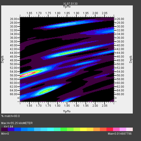
| Thickness Estimate: | 55 km |
| Thickness StdDev: | 4.5 km |
| Vp/Vs Estimate: | 1.64 |
| Vp/Vs StdDev: | 0.07 |
| Vs Estimate: | 3.836 km/s |
| Poisson's Ratio: | 0.20 |
| Peak Value: | 0.01 |
| Assumed Vp: | 6.291 km/s |
| Ps Weight: | 0.33333334 |
| PpPs Weight: | 0.33333334 |
| PsPs Weight: | 0.33333328 |
| Residual Complexity: | 0.692 |
| Nearby stations H: | +- |
| (2.0 deg) Vp/Vs: | +- |
6 with match > 90% ( 24.0 %) and 15 with match > 80% ( 60.0 %) out of 25.
Download stack as xyz text file.
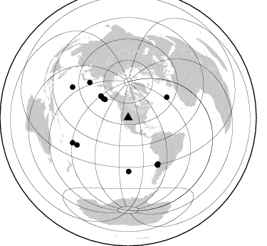
Azimuth Distribution of Events:
Prior Results for this Station
| Study | Thickness | Vp/Vs | Vp | Vs | Poissons Ratio | Extra |
| EARS | 55 km | 1.64 | 6.291 km/s | 3.836 km/s | 0.20 | |
| Crust2.0 | 43 km | 1.76 | 6.291 km/s | 3.577 km/s | 0.26 | Q3,orogen/43km no ice, Appalachians, 3 km seds. |
| Global Maxima | 55 km | 1.64 | 6.291 km/s | 3.836 km/s | 0.20 | amp=0.014687796 |
| Local Maxima 1 | 64 km | 1.74 | 6.291 km/s | 3.626 km/s | 0.25 | amp=0.008444909 |
| Local Maxima 2 | 44 km | 1.87 | 6.291 km/s | 3.373 km/s | 0.30 | amp=0.008273411 |
| Local Maxima 3 | 28 km | 1.84 | 6.291 km/s | 3.424 km/s | 0.29 | amp=0.004637769 |
| Local Maxima 4 | 70 km | 1.84 | 6.291 km/s | 3.419 km/s | 0.29 | amp=0.00398204 |
| Predicted Arrivals for vertical incidence (zero ray parameter) | |
| Ps | 5.62 SECOND |
| PpPs | 23.19 SECOND |
| PsPs/PpSs | 28.81 SECOND |
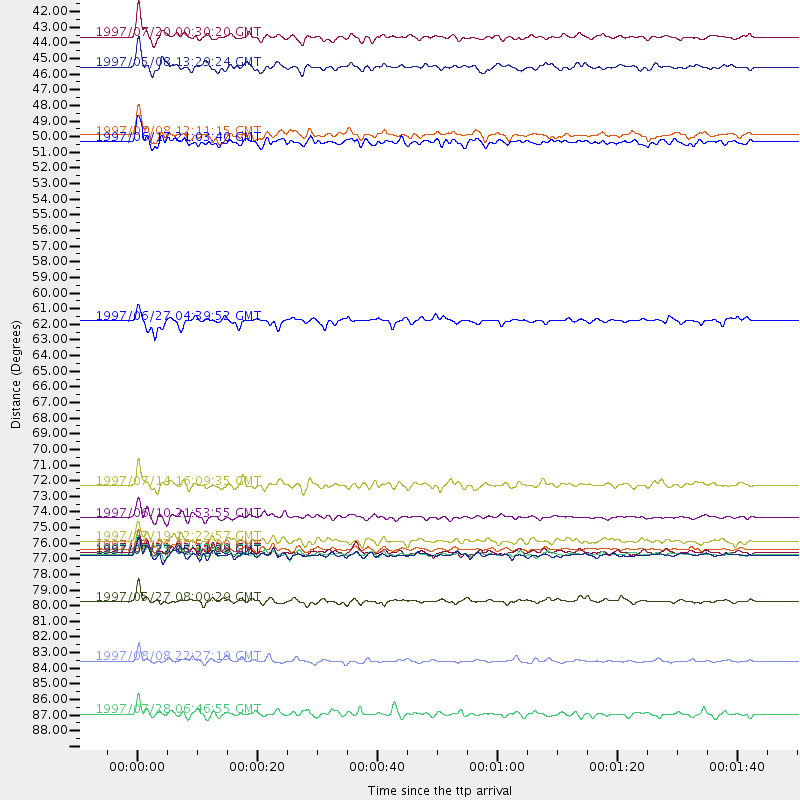
Events Processed for this Station
Download zip of receiver functions as SAC
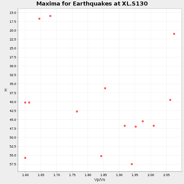
Plot maxima for each earthquake.
Events Used in the Stack
(15 events)| Radial Match | Distance | Baz | FERegion | Time | Lat/Lon | Depth | Magnitude |
| 94.228355 | 77.5 deg | 147.783 deg | Near Coast Of Central Chile | 1997/07/06 09:54:00 GMT | (-30.1, -71.9) | 19 km | 5.8 MB, 6.5 MS, 6.8 UNKNOWN, 6.4 ME |
| 92.330444 | 77.9 deg | 147.996 deg | Near Coast Of Central Chile | 1997/07/27 05:21:29 GMT | (-30.5, -71.9) | 33 km | 5.6 MB, 5.8 MS, 6.3 UNKNOWN, 6.2 MW |
| 91.83867 | 41.5 deg | 307.995 deg | Fox Islands, Aleutian Islands | 1997/07/20 00:30:20 GMT | (52.6, -167.5) | 14 km | 5.6 MB, 5.9 MS, 6.2 UNKNOWN, 6.2 MW |
| 91.46592 | 85.4 deg | 245.654 deg | Fiji Islands Region | 1997/08/08 22:27:19 GMT | (-15.5, -179.1) | 10 km | 5.7 MB, 6.6 MS, 6.6 UNKNOWN, 6.4 MW |
| 90.528496 | 75.3 deg | 179.463 deg | Southern East Pacific Rise | 1997/06/10 21:53:55 GMT | (-35.8, -108.1) | 10 km | 5.8 MB, 6.1 MS, 6.5 UNKNOWN, 5.8 MS |
| 90.48019 | 43.6 deg | 307.172 deg | Fox Islands, Aleutian Islands | 1997/05/08 13:29:24 GMT | (51.7, -170.8) | 33 km | 5.8 MB, 5.9 MS, 6.0 UNKNOWN, 6.0 MW |
| 89.08562 | 48.9 deg | 308.267 deg | Andreanof Islands, Aleutian Is. | 1997/06/17 21:03:40 GMT | (51.3, -179.3) | 33 km | 6.4 MB, 6.3 MS, 6.4 UNKNOWN, 6.6 ML |
| 87.1033 | 73.1 deg | 312.409 deg | Kuril Islands | 1997/07/14 16:09:35 GMT | (43.2, 146.4) | 33 km | 5.9 MB, 5.8 MS, 6.1 UNKNOWN, 5.8 ME |
| 85.25385 | 61.5 deg | 62.44 deg | Azores Islands, Portugal | 1997/06/27 04:39:52 GMT | (38.3, -26.7) | 10 km | 5.6 MB, 5.4 MS, 5.9 UNKNOWN, 5.9 MW |
| 83.953636 | 77.9 deg | 148.004 deg | Near Coast Of Central Chile | 1997/07/25 06:47:02 GMT | (-30.5, -71.9) | 33 km | 5.6 MB, 5.5 MS, 6.3 UNKNOWN |
| 83.89572 | 89.1 deg | 298.595 deg | Volcano Islands, Japan Region | 1997/07/28 06:46:55 GMT | (22.4, 142.7) | 33 km | 5.7 MB, 5.8 MS, 5.9 UNKNOWN, 5.9 MW |
| 82.774864 | 48.4 deg | 308.135 deg | Andreanof Islands, Aleutian Is. | 1997/07/08 12:11:15 GMT | (51.4, -178.6) | 33 km | 5.5 MB, 5.4 MS, 5.8 UNKNOWN, 5.6 ML |
| 82.23738 | 81.2 deg | 241.901 deg | Tonga Islands | 1997/05/27 08:00:29 GMT | (-15.2, -173.3) | 14 km | 5.6 MB, 6.3 MS, 6.4 UNKNOWN, 5.7 ME |
| 81.87237 | 76.9 deg | 147.258 deg | Near Coast Of Central Chile | 1997/07/19 12:22:57 GMT | (-29.3, -71.7) | 26 km | 5.8 MB, 5.5 MS, 5.9 UNKNOWN, 5.8 MW |
| 80.34935 | 77.8 deg | 147.948 deg | Near Coast Of Central Chile | 1997/07/21 23:19:39 GMT | (-30.3, -71.9) | 33 km | 5.2 MB, 5.5 MS, 6.1 UNKNOWN |
Losers
(10 events)| Radial Match | Distance | Baz | FERegion | Time | Lat/Lon | Depth | Magnitude | Reason |
| 77.35025 | 88.2 deg | 299.667 deg | Volcano Islands, Japan Region | 1997/07/08 02:24:07 GMT | (23.8, 142.7) | 33 km | 5.8 MB, 5.6 MS, 5.9 UNKNOWN, 5.8 MW | |
| 76.70279 | 74.0 deg | 139.657 deg | Jujuy Province, Argentina | 1997/07/20 10:14:22 GMT | (-23.0, -66.3) | 256 km | 5.7 MB, 6.1 UNKNOWN, 5.7 ME | |
| 64.4715 | 93.9 deg | 290.625 deg | Mariana Islands | 1997/05/09 09:06:37 GMT | (13.2, 144.7) | 29 km | 5.9 MB, 5.8 MS, 6.0 UNKNOWN, 6.0 ME | |
| 61.196384 | 91.9 deg | 38.773 deg | Central Mediterranean Sea | 1997/07/27 10:07:52 GMT | (35.6, 21.1) | 33 km | 5.5 MB, 4.8 MS, 5.6 UNKNOWN, 5.2 ML | |
| 60.333553 | 96.9 deg | 249.282 deg | Vanuatu Islands | 1997/05/21 14:10:26 GMT | (-20.4, 169.3) | 57 km | 5.9 MB, 6.5 MS, 6.7 UNKNOWN, 6.1 ME | |
| 46.06745 | 90.1 deg | 238.483 deg | South Of Fiji Islands | 1997/06/11 09:29:23 GMT | (-24.0, -177.5) | 164 km | 5.9 UNKNOWN, 5.4 MB, 5.5 MB | |
| 44.52485 | 93.6 deg | 246.091 deg | Vanuatu Islands Region | 1997/06/24 16:17:09 GMT | (-20.7, 174.2) | 33 km | 5.5 MS, 5.2 MB, 5.9 UNKNOWN, 5.9 MW | |
| 44.177574 | 97.3 deg | 195.531 deg | Pacific-Antarctic Ridge | 1997/05/27 06:10:31 GMT | (-54.9, -136.2) | 10 km | 5.9 MS, 5.3 MB, 6.1 UNKNOWN, 6.0 MW | |
| 40.371685 | 91.3 deg | 292.448 deg | Mariana Islands | 1997/05/27 15:09:03 GMT | (16.3, 145.4) | 536 km | 5.5 MB, 5.6 UNKNOWN, 5.6 MW | |
| 16.796059 | 86.8 deg | 243.762 deg | Fiji Islands Region | 1997/06/11 11:53:32 GMT | (-17.8, -178.8) | 573 km | 5.5 UNKNOWN, 4.9 MB |
