
Station XL S217 - Big Brush Creek
Network: XL97 - Deep Probe (Archean-Proterozoic)
Nearby stations (2 deg radius)
| Station | Name | (Lat, Lon) | Start / End | Elevation |
| S217 | Big Brush Creek | (40.70, -109.51) | 1997-08-21 / 1997-12-31 | 2577 m |
| Crust2 Type: | Q4,orogen/43km no ice, Tethian Belt, 5 km seds. |
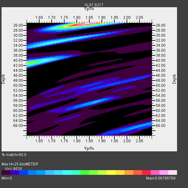
| Thickness Estimate: | 25 km |
| Thickness StdDev: | 3.6 km |
| Vp/Vs Estimate: | 1.85 |
| Vp/Vs StdDev: | 0.07 |
| Vs Estimate: | 3.351 km/s |
| Poisson's Ratio: | 0.29 |
| Peak Value: | 0.07 |
| Assumed Vp: | 6.207 km/s |
| Ps Weight: | 0.33333334 |
| PpPs Weight: | 0.33333334 |
| PsPs Weight: | 0.33333328 |
| Residual Complexity: | 0.634 |
| Nearby stations H: | +- |
| (2.0 deg) Vp/Vs: | +- |
2 with match > 90% ( 13.333333 %) and 4 with match > 80% ( 26.666666 %) out of 15.
Download stack as xyz text file.
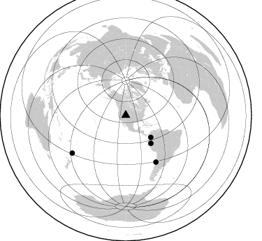
Azimuth Distribution of Events:
Prior Results for this Station
| Study | Thickness | Vp/Vs | Vp | Vs | Poissons Ratio | Extra |
| EARS | 25 km | 1.85 | 6.207 km/s | 3.351 km/s | 0.29 | |
| Crust2.0 | 43 km | 1.76 | 6.207 km/s | 3.535 km/s | 0.26 | Q4,orogen/43km no ice, Tethian Belt, 5 km seds. |
| Global Maxima | 25 km | 1.85 | 6.207 km/s | 3.351 km/s | 0.29 | amp=0.06795769 |
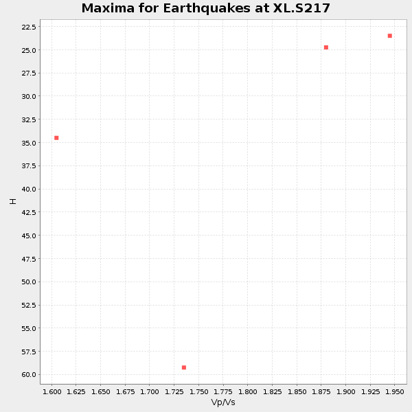
| Local Maxima 1 | 41 km | 1.60 | 6.207 km/s | 3.879 km/s | 0.18 | amp=0.039530408 |
| Local Maxima 2 | 32 km | 1.74 | 6.207 km/s | 3.567 km/s | 0.25 | amp=0.026573913 |
| Local Maxima 3 | 56 km | 1.88 | 6.207 km/s | 3.302 km/s | 0.30 | amp=0.017703228 |
| Local Maxima 4 | 65 km | 2.08 | 6.207 km/s | 2.991 km/s | 0.35 | amp=0.017298609 |
| Predicted Arrivals for vertical incidence (zero ray parameter) | |
| Ps | 3.43 SECOND |
| PpPs | 11.49 SECOND |
| PsPs/PpSs | 14.92 SECOND |
Events Processed for this Station
Download zip of receiver functions as SAC
Plot maxima for each earthquake.
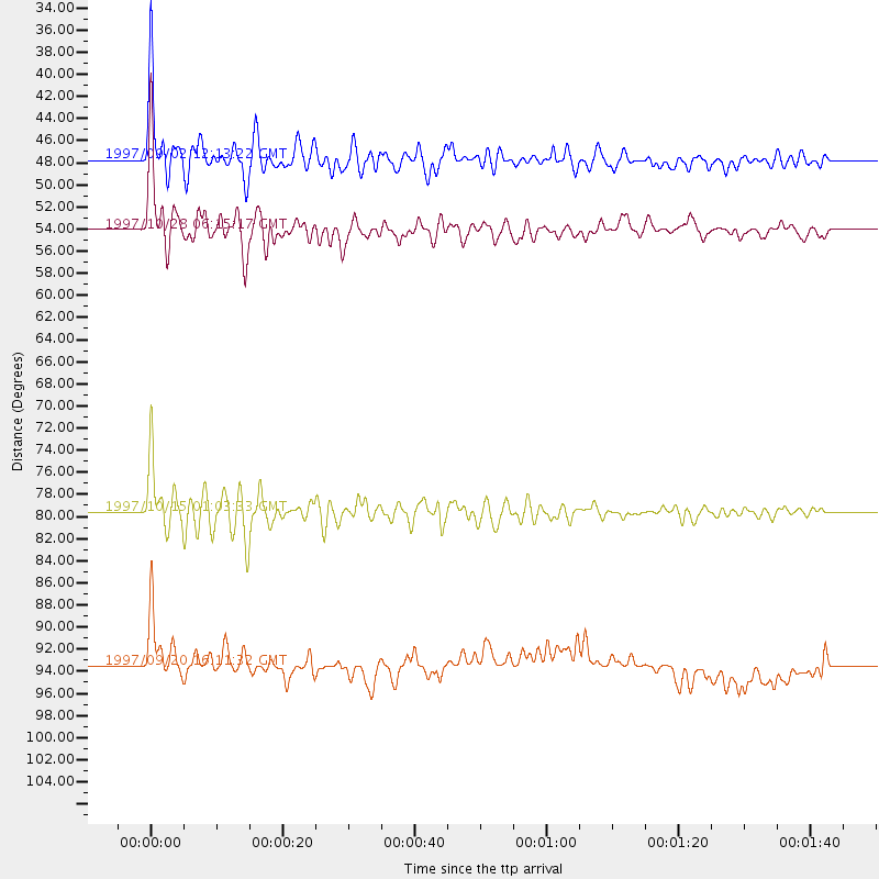
Events Used in the Stack
(4 events)| Radial Match | Distance | Baz | FERegion | Time | Lat/Lon | Depth | Magnitude |
| 95.48525 | 79.6 deg | 147.223 deg | Near Coast Of Central Chile | 1997/10/15 01:03:33 GMT | (-30.9, -71.2) | 58 km | 6.8 MB, 6.8 MS, 7.3 UNKNOWN, 7.1 MW |
| 93.299934 | 54.0 deg | 138.063 deg | Northern Peru | 1997/10/28 06:15:17 GMT | (-4.4, -76.7) | 112 km | 6.6 MB, 6.3 MS, 7.2 UNKNOWN, 6.6 ME |
| 89.76312 | 47.6 deg | 131.354 deg | Colombia | 1997/09/02 12:13:22 GMT | (3.8, -75.7) | 199 km | 6.5 MB, 6.8 UNKNOWN, 6.4 ME |
| 81.79061 | 93.5 deg | 234.769 deg | Kermadec Islands Region | 1997/09/20 16:11:32 GMT | (-28.7, -177.6) | 30 km | 6.1 MB, 7.0 MS, 7.2 UNKNOWN, 6.7 ME |
Losers
(11 events)| Radial Match | Distance | Baz | FERegion | Time | Lat/Lon | Depth | Magnitude | Reason |
| 70.05419 | 93.6 deg | 255.948 deg | Vanuatu Islands | 1997/10/31 12:29:49 GMT | (-13.1, 166.9) | 183 km | 5.9 UNKNOWN, 5.4 MB | |
| 66.42709 | 88.8 deg | 241.051 deg | Fiji Islands Region | 1997/10/17 15:02:00 GMT | (-20.9, -178.8) | 579 km | 5.3 MB, 6.0 UNKNOWN, 6.0 MW | |
| 63.916405 | 94.6 deg | 238.787 deg | South Of Fiji Islands | 1997/09/04 04:23:37 GMT | (-26.6, 178.3) | 625 km | 6.3 MB, 6.8 UNKNOWN, 6.5 ME | |
| 58.914783 | 86.9 deg | 237.877 deg | Tonga Islands | 1997/10/19 15:53:38 GMT | (-21.8, -175.0) | 33 km | 5.6 MB, 5.9 MS | |
| 58.64316 | 86.2 deg | 237.762 deg | Tonga Islands | 1997/09/10 12:57:07 GMT | (-21.3, -174.4) | 10 km | 5.7 MB, 6.1 MS, 6.1 UNKNOWN, 5.9 MW | |
| 54.709946 | 78.0 deg | 311.816 deg | Eastern Honshu, Japan | 1997/10/26 19:06:44 GMT | (39.3, 140.5) | 134 km | 5.6 UNKNOWN, 5.2 MB | |
| 53.52552 | 88.0 deg | 240.413 deg | Fiji Islands Region | 1997/08/25 11:59:00 GMT | (-20.8, -177.8) | 394 km | 5.5 UNKNOWN, 5.3 MB | |
| 51.178165 | 97.0 deg | 191.106 deg | Pacific-Antarctic Ridge | 1997/09/03 06:22:44 GMT | (-55.2, -129.0) | 10 km | 5.1 MB, 6.0 MS, 6.1 UNKNOWN, 6.0 MW | |
| 50.757748 | 73.5 deg | 140.65 deg | Northern Chile | 1997/09/28 23:13:13 GMT | (-22.4, -68.4) | 107 km | 5.7 MB, 5.6 UNKNOWN, 5.6 MW | |
| 35.483234 | 71.2 deg | 313.137 deg | Kuril Islands | 1997/10/22 09:55:47 GMT | (44.7, 146.2) | 154 km | 5.5 MB, 5.6 UNKNOWN, 5.6 MW | |
| 29.657606 | 96.6 deg | 193.642 deg | Pacific-Antarctic Ridge | 1997/10/26 13:55:33 GMT | (-54.1, -133.0) | 10 km | 5.5 MS, 5.1 MB |
