
Station XL S237 - Battlement Mesa
Network: XL97 - Deep Probe (Archean-Proterozoic)
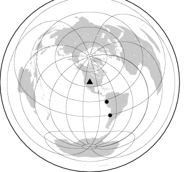
Nearby stations (2 deg radius)
| Station | Name | (Lat, Lon) | Start / End | Elevation |
| S237 | Battlement Mesa | (39.12, -107.89) | 1997-08-31 / 1997-12-31 | 3012 m |
| Crust2 Type: | P4,orogen/50km, Urals, Tethian Orogen, Rockies 1 km seds. |
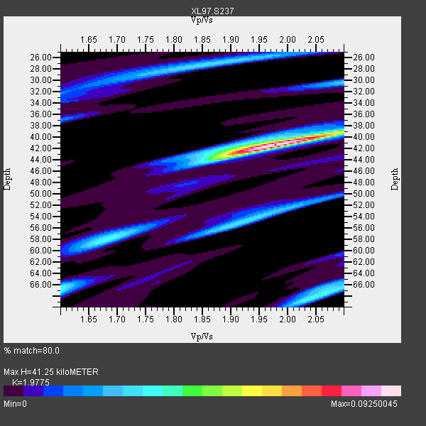
| Thickness Estimate: | 41 km |
| Thickness StdDev: | 0.8 km |
| Vp/Vs Estimate: | 1.98 |
| Vp/Vs StdDev: | 0.05 |
| Vs Estimate: | 3.189 km/s |
| Poisson's Ratio: | 0.33 |
| Peak Value: | 0.09 |
| Assumed Vp: | 6.306 km/s |
| Ps Weight: | 0.33333334 |
| PpPs Weight: | 0.33333334 |
| PsPs Weight: | 0.33333328 |
| Residual Complexity: | 0.573 |
| Nearby stations H: | +- |
| (2.0 deg) Vp/Vs: | +- |
0 with match > 90% ( 0.0 %) and 2 with match > 80% ( 25.0 %) out of 8.
Download stack as xyz text file.
Azimuth Distribution of Events:
Prior Results for this Station
| Study | Thickness | Vp/Vs | Vp | Vs | Poissons Ratio | Extra |
| EARS | 41 km | 1.98 | 6.306 km/s | 3.189 km/s | 0.33 | |
| Crust2.0 | 50 km | 1.76 | 6.306 km/s | 3.584 km/s | 0.26 | P4,orogen/50km, Urals, Tethian Orogen, Rockies 1 km seds. |
| Global Maxima | 41 km | 1.98 | 6.306 km/s | 3.189 km/s | 0.33 | amp=0.09250045 |
| Local Maxima 1 | 68 km | 2.05 | 6.306 km/s | 3.072 km/s | 0.34 | amp=0.03910317 |
| Local Maxima 2 | 58 km | 1.68 | 6.306 km/s | 3.759 km/s | 0.22 | amp=0.032417256 |
| Local Maxima 3 | 55 km | 1.91 | 6.306 km/s | 3.293 km/s | 0.31 | amp=0.031042334 |
| Local Maxima 4 | 27 km | 1.85 | 6.306 km/s | 3.413 km/s | 0.29 | amp=0.029248996 |
| Predicted Arrivals for vertical incidence (zero ray parameter) | |
| Ps | 6.39 SECOND |
| PpPs | 19.48 SECOND |
| PsPs/PpSs | 25.87 SECOND |
Events Processed for this Station
Download zip of receiver functions as SAC
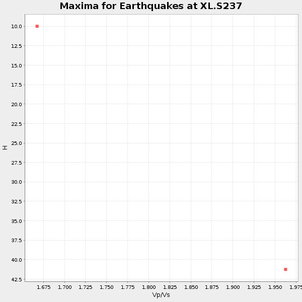
Plot maxima for each earthquake.
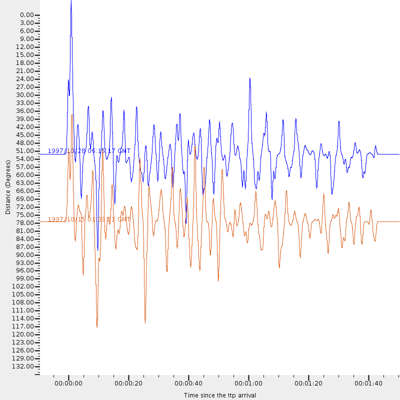
Events Used in the Stack
(2 events)| Radial Match | Distance | Baz | FERegion | Time | Lat/Lon | Depth | Magnitude |
| 85.03704 | 52.0 deg | 139.016 deg | Northern Peru | 1997/10/28 06:15:17 GMT | (-4.4, -76.7) | 112 km | 6.6 MB, 6.3 MS, 7.2 UNKNOWN, 6.6 ME |
| 81.026405 | 77.6 deg | 148.301 deg | Near Coast Of Central Chile | 1997/10/15 01:03:33 GMT | (-30.9, -71.2) | 58 km | 6.8 MB, 6.8 MS, 7.3 UNKNOWN, 7.1 MW |
Losers
(6 events)| Radial Match | Distance | Baz | FERegion | Time | Lat/Lon | Depth | Magnitude | Reason |
| 75.09038 | 49.0 deg | 308.743 deg | Andreanof Islands, Aleutian Is. | 1997/10/15 03:11:09 GMT | (51.4, -177.9) | 22 km | 5.7 MB, 6.1 MS, 6.3 UNKNOWN, 5.6 ML | |
| 63.20964 | 94.9 deg | 239.658 deg | South Of Fiji Islands | 1997/09/04 04:23:37 GMT | (-26.6, 178.3) | 625 km | 6.3 MB, 6.8 UNKNOWN, 6.5 ME | |
| 60.322598 | 95.7 deg | 191.971 deg | Pacific-Antarctic Ridge | 1997/09/03 06:22:44 GMT | (-55.2, -129.0) | 10 km | 5.1 MB, 6.0 MS, 6.1 UNKNOWN, 6.0 MW | |
| 58.790047 | 93.6 deg | 235.679 deg | Kermadec Islands Region | 1997/09/20 16:11:32 GMT | (-28.7, -177.6) | 30 km | 6.1 MB, 7.0 MS, 7.2 UNKNOWN, 6.7 ME | |
| 42.577778 | 87.2 deg | 239.015 deg | Tonga Islands | 1997/10/19 15:53:38 GMT | (-21.8, -175.0) | 33 km | 5.6 MB, 5.9 MS | |
| 42.39761 | 89.2 deg | 242.122 deg | Fiji Islands Region | 1997/10/17 15:02:00 GMT | (-20.9, -178.8) | 579 km | 5.3 MB, 6.0 UNKNOWN, 6.0 MW |
