
Station XM NM30 - NewMexico30
Network: XM99 - Rio Grande Seismic Transect
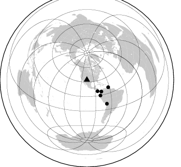
Nearby stations (2 deg radius)
| Station | Name | (Lat, Lon) | Start / End | Elevation |
| NM30 | NewMexico30 | (34.74, -106.97) | 1999-09-15 / 2001-12-31 | 1515 m |
| Crust2 Type: | X2,Rift, Rio Grande, Baikal, 0.5km sediments |
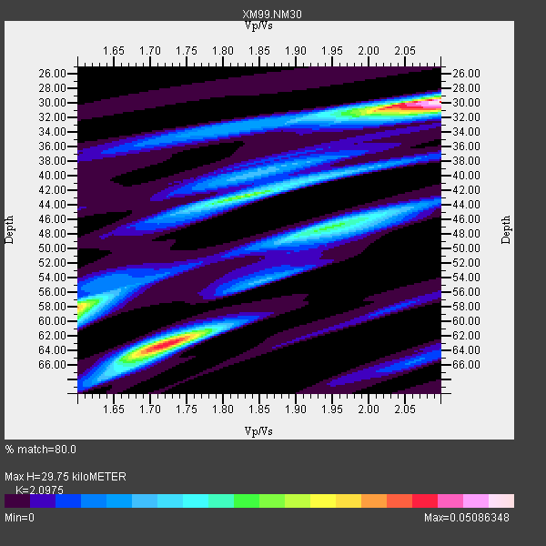
| Thickness Estimate: | 30 km |
| Thickness StdDev: | 15 km |
| Vp/Vs Estimate: | 2.10 |
| Vp/Vs StdDev: | 0.21 |
| Vs Estimate: | 3.1 km/s |
| Poisson's Ratio: | 0.35 |
| Peak Value: | 0.05 |
| Assumed Vp: | 6.502 km/s |
| Ps Weight: | 0.33333334 |
| PpPs Weight: | 0.33333334 |
| PsPs Weight: | 0.33333328 |
| Residual Complexity: | 0.788 |
| Nearby stations H: | +- |
| (2.0 deg) Vp/Vs: | +- |
0 with match > 90% ( 0.0 %) and 5 with match > 80% ( 100.0 %) out of 5.
Download stack as xyz text file.
Azimuth Distribution of Events:
Prior Results for this Station
| Study | Thickness | Vp/Vs | Vp | Vs | Poissons Ratio | Extra |
| EARS | 30 km | 2.10 | 6.502 km/s | 3.1 km/s | 0.35 | |
| Crust2.0 | 33 km | 1.77 | 6.502 km/s | 3.68 km/s | 0.26 | X2,Rift, Rio Grande, Baikal, 0.5km sediments |
| Wilson | 38 km | 1.78 | 6.15 km/s | 3.455 km/s | 0.27 | |
| Global Maxima | 30 km | 2.10 | 6.502 km/s | 3.1 km/s | 0.35 | amp=0.05086348 |
| Local Maxima 1 | 63 km | 1.72 | 6.502 km/s | 3.785 km/s | 0.24 | amp=0.042750217 |
| Local Maxima 2 | 58 km | 1.60 | 6.502 km/s | 4.063 km/s | 0.18 | amp=0.035068315 |
| Local Maxima 3 | 42 km | 1.84 | 6.502 km/s | 3.543 km/s | 0.29 | amp=0.02713307 |
| Local Maxima 4 | 47 km | 1.94 | 6.502 km/s | 3.347 km/s | 0.32 | amp=0.021391056 |
| Predicted Arrivals for vertical incidence (zero ray parameter) | |
| Ps | 5.02 SECOND |
| PpPs | 14.17 SECOND |
| PsPs/PpSs | 19.20 SECOND |
Events Processed for this Station
Download zip of receiver functions as SAC
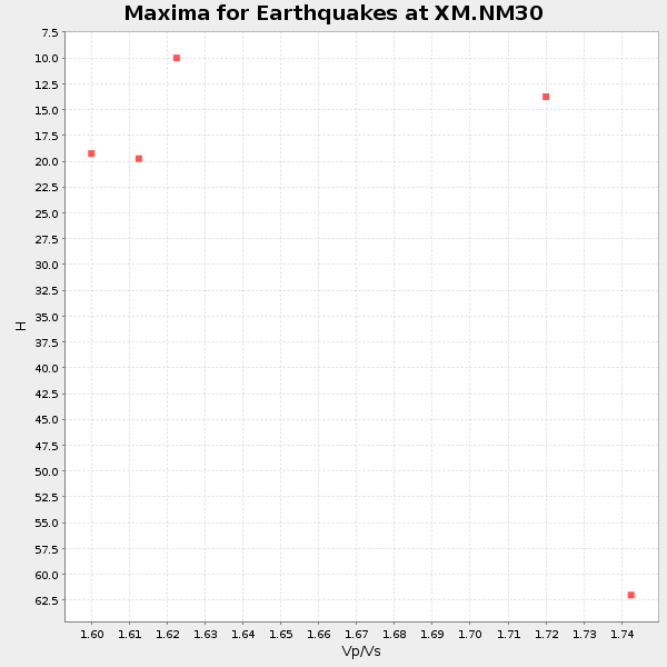
Plot maxima for each earthquake.
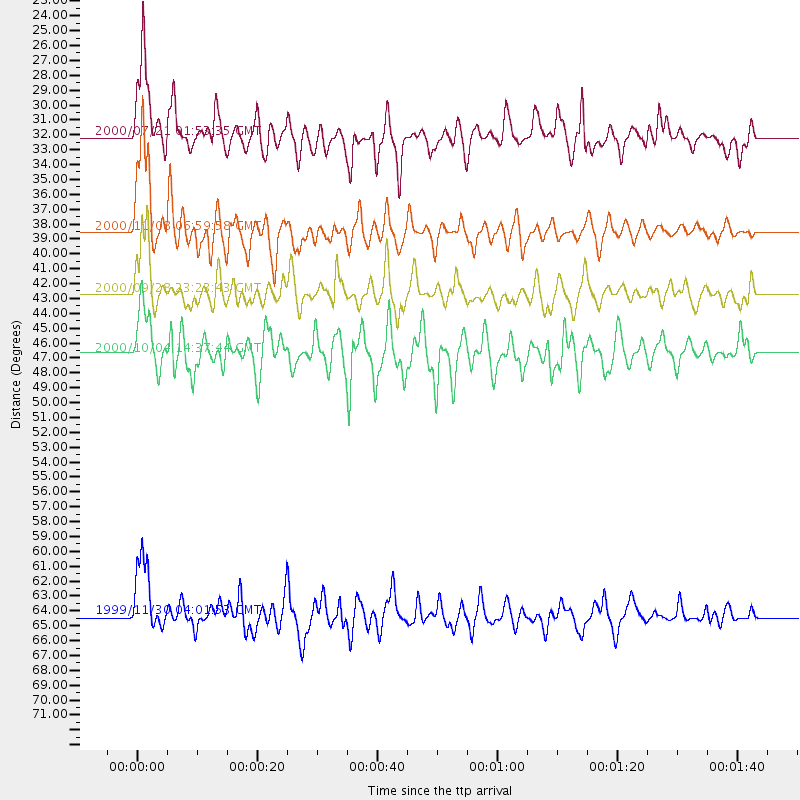
Events Used in the Stack
(5 events)| Radial Match | Distance | Baz | FERegion | Time | Lat/Lon | Depth | Magnitude |
| 85.938736 | 46.7 deg | 109.249 deg | Windward Islands | 2000/10/04 14:37:44 GMT | (11.1, -62.6) | 110 km | 5.6 MB, 5.4 MS, 6.1 MW, 5.9 MD |
| 85.78725 | 32.1 deg | 136.718 deg | Off Coast Of Costa Rica | 2000/07/21 01:53:35 GMT | (9.4, -85.3) | 33 km | 5.9 MB, 6.1 MS, 6.4 MW, 5.7 ML |
| 82.74659 | 38.5 deg | 129.004 deg | Panama-Colombia Border Region | 2000/11/08 06:59:58 GMT | (7.0, -77.8) | 17 km | 6.0 MB, 6.4 MS, 6.5 MW, 6.2 ML |
| 81.30244 | 42.6 deg | 138.995 deg | Near Coast Of Ecuador | 2000/09/28 23:23:43 GMT | (-0.2, -80.6) | 23 km | 5.8 MB, 6.0 MS, 6.6 MW, 6.4 MW |
| 80.79959 | 64.3 deg | 139.917 deg | Northern Chile | 1999/11/30 04:01:53 GMT | (-18.9, -69.2) | 128 km | 6.2 MB, 6.6 MW, 6.5 MW |
Losers
(0 events)| Radial Match | Distance | Baz | FERegion | Time | Lat/Lon | Depth | Magnitude | Reason |
