
Station XR FA21 - fled station 21
Network: XR01 - Florida to Edmonton Seismic Experiment
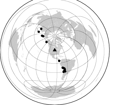
Nearby stations (2 deg radius)
| Station | Name | (Lat, Lon) | Start / End | Elevation |
| FA21 | fled station 21 | (43.74, -96.62) | 2001-06-01 / 2002-12-31 | 0.5 km |
| Crust2 Type: | D9,Platform 1 km seds. |
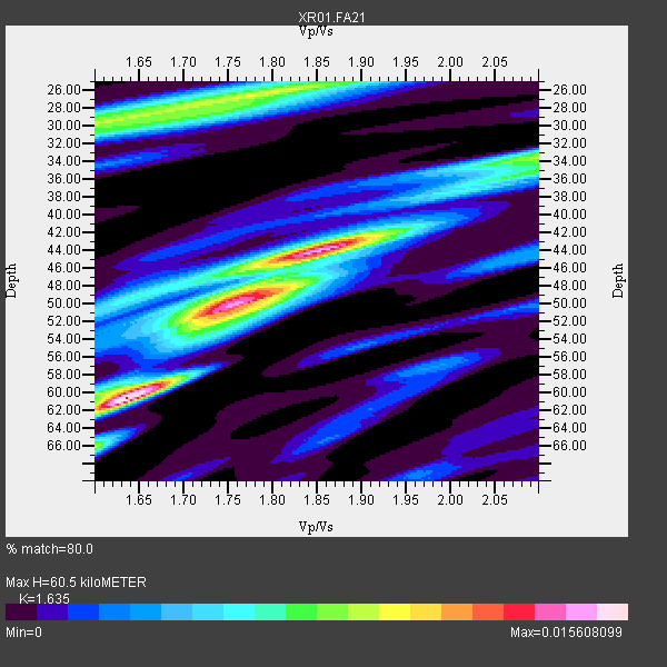
| Thickness Estimate: | 60 km |
| Thickness StdDev: | 11 km |
| Vp/Vs Estimate: | 1.63 |
| Vp/Vs StdDev: | 0.09 |
| Vs Estimate: | 3.974 km/s |
| Poisson's Ratio: | 0.20 |
| Peak Value: | 0.02 |
| Assumed Vp: | 6.498 km/s |
| Ps Weight: | 0.33333334 |
| PpPs Weight: | 0.33333334 |
| PsPs Weight: | 0.33333328 |
| Residual Complexity: | 0.892 |
| Nearby stations H: | +- |
| (2.0 deg) Vp/Vs: | +- |
11 with match > 90% ( 68.75 %) and 16 with match > 80% ( 100.0 %) out of 16.
Download stack as xyz text file.
Azimuth Distribution of Events:
Prior Results for this Station
| Study | Thickness | Vp/Vs | Vp | Vs | Poissons Ratio | Extra |
| EARS | 60 km | 1.63 | 6.498 km/s | 3.974 km/s | 0.20 | |
| Crust2.0 | 41 km | 1.77 | 6.498 km/s | 3.666 km/s | 0.27 | D9,Platform 1 km seds. |
| Global Maxima | 60 km | 1.63 | 6.498 km/s | 3.974 km/s | 0.20 | amp=0.015608099 |
| Local Maxima 1 | 44 km | 1.85 | 6.498 km/s | 3.517 km/s | 0.29 | amp=0.014412894 |
| Local Maxima 2 | 50 km | 1.75 | 6.498 km/s | 3.702 km/s | 0.26 | amp=0.010890322 |
| Local Maxima 3 | 26 km | 1.77 | 6.498 km/s | 3.661 km/s | 0.27 | amp=0.009478578 |
| Local Maxima 4 | 34 km | 2.09 | 6.498 km/s | 3.105 km/s | 0.35 | amp=0.007422984 |
| Predicted Arrivals for vertical incidence (zero ray parameter) | |
| Ps | 5.91 SECOND |
| PpPs | 24.53 SECOND |
| PsPs/PpSs | 30.45 SECOND |
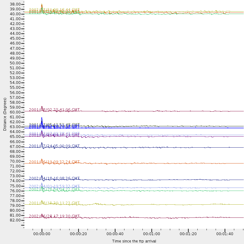
Events Processed for this Station
Download zip of receiver functions as SAC
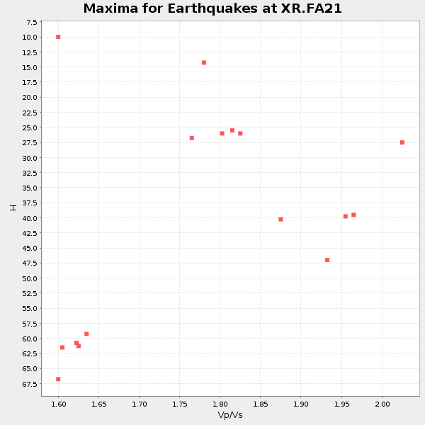
Plot maxima for each earthquake.
Events Used in the Stack
(16 events)| Radial Match | Distance | Baz | FERegion | Time | Lat/Lon | Depth | Magnitude |
| 99.9671 | 63.5 deg | 318.475 deg | Off East Coast Of Kamchatka | 2001/10/08 18:20:38 GMT | (52.6, 160.2) | 33 km | 5.9 MB, 6.4 MW, 6.1 MW |
| 97.80791 | 63.3 deg | 155.182 deg | Near Coast Of Peru | 2001/06/23 20:33:14 GMT | (-16.3, -73.6) | 33 km | 6.7 MB, 8.2 MS, 8.4 MW, 7.8 ME |
| 97.70044 | 65.0 deg | 154.066 deg | Near Coast Of Peru | 2001/07/07 09:38:43 GMT | (-17.5, -72.1) | 33 km | 6.6 MB, 7.3 MS, 7.6 MW, 7.5 ME |
| 96.3724 | 76.6 deg | 157.576 deg | Near Coast Of Central Chile | 2002/04/01 19:59:32 GMT | (-29.7, -71.4) | 71 km | 6.1 MB, 6.4 MW, 6.4 MW |
| 95.740585 | 65.3 deg | 153.717 deg | Near Coast Of Peru | 2001/06/26 04:18:31 GMT | (-17.7, -71.6) | 24 km | 6.2 MB, 6.7 MS, 6.8 MW, 6.7 ME |
| 95.73978 | 59.7 deg | 320.417 deg | Near East Coast Of Kamchatka | 2001/08/02 23:41:06 GMT | (56.3, 163.8) | 14 km | 5.9 MB, 6.2 MS, 6.3 MW, 6.2 ME |
| 95.26076 | 77.3 deg | 153.457 deg | Catamarca Province, Argentina | 2002/05/28 04:04:22 GMT | (-28.9, -66.8) | 22 km | 6.0 MB, 5.7 MS, 6.0 MW, 5.9 MW |
| 94.78104 | 67.7 deg | 152.04 deg | Northern Chile | 2001/07/24 05:00:09 GMT | (-19.4, -69.3) | 33 km | 5.7 MB, 6.2 MS, 6.3 MW, 6.3 MW |
| 92.696594 | 63.0 deg | 155.472 deg | Near Coast Of Peru | 2001/07/05 13:53:48 GMT | (-16.1, -74.0) | 62 km | 6.2 MB, 6.6 MW, 6.5 ME |
| 91.62878 | 37.7 deg | 157.2 deg | South Of Panama | 2002/07/31 00:16:44 GMT | (7.9, -82.8) | 10 km | 6.0 MB, 6.4 MS, 6.5 MW, 6.4 MW |
| 91.238174 | 38.2 deg | 314.553 deg | Southern Alaska | 2001/07/28 07:32:43 GMT | (59.0, -155.1) | 131 km | 5.7 MB, 5.7 MS, 6.6 MW, 6.2 ME |
| 89.15279 | 80.3 deg | 318.915 deg | Hokkaido, Japan Region | 2001/08/13 20:11:23 GMT | (41.0, 142.3) | 38 km | 6.0 MB, 6.3 MS, 6.4 MW, 6.3 ME |
| 88.49971 | 38.0 deg | 157.294 deg | South Of Panama | 2001/08/25 02:02:02 GMT | (7.6, -82.8) | 24 km | 5.9 MB, 5.7 MS, 6.2 MW, 6.1 MW |
| 84.95672 | 71.2 deg | 152.033 deg | Chile-Bolivia Border Region | 2001/06/19 09:32:24 GMT | (-22.7, -67.9) | 147 km | 5.5 MB, 5.2 MS, 6.1 MW, 5.9 MW |
| 83.016945 | 83.2 deg | 327.571 deg | E. Russia-N.E. China Border Reg. | 2002/06/28 17:19:30 GMT | (43.8, 130.7) | 566 km | 6.7 MB, 7.3 MW, 7.3 MW |
| 82.506004 | 74.8 deg | 156.181 deg | Near Coast Of Northern Chile | 2002/04/18 16:08:36 GMT | (-27.5, -70.6) | 62 km | 6.2 MB, 6.7 MW, 6.6 MW |
Losers
(0 events)| Radial Match | Distance | Baz | FERegion | Time | Lat/Lon | Depth | Magnitude | Reason |
