
Station XS S09 - XS.S09
Network: XS99 - Montana BB Array
Nearby stations (2 deg radius)
| Station | Name | (Lat, Lon) | Start / End | Elevation |
| S09 | XS.S09 | (45.56, -109.20) | 1999-08-21 / 2000-08-25 | 1800 m |
| Crust2 Type: | PD,orogen/50km, Tibet, 2 km seds. |
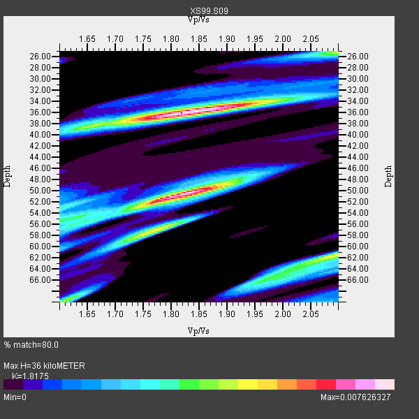
| Thickness Estimate: | 36 km |
| Thickness StdDev: | 13 km |
| Vp/Vs Estimate: | 1.82 |
| Vp/Vs StdDev: | 0.15 |
| Vs Estimate: | 3.434 km/s |
| Poisson's Ratio: | 0.28 |
| Peak Value: | 0.01 |
| Assumed Vp: | 6.242 km/s |
| Ps Weight: | 0.33333334 |
| PpPs Weight: | 0.33333334 |
| PsPs Weight: | 0.33333328 |
| Residual Complexity: | 0.772 |
| Nearby stations H: | +- |
| (2.0 deg) Vp/Vs: | +- |
5 with match > 90% ( 31.25 %) and 16 with match > 80% ( 100.0 %) out of 16.
Download stack as xyz text file.
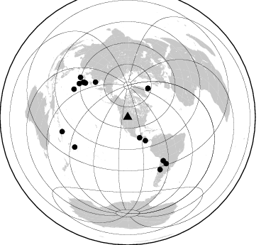
Azimuth Distribution of Events:
Prior Results for this Station
| Study | Thickness | Vp/Vs | Vp | Vs | Poissons Ratio | Extra |
| EARS | 36 km | 1.82 | 6.242 km/s | 3.434 km/s | 0.28 | |
| Crust2.0 | 50 km | 1.76 | 6.242 km/s | 3.546 km/s | 0.26 | PD,orogen/50km, Tibet, 2 km seds. |
| Global Maxima | 36 km | 1.82 | 6.242 km/s | 3.434 km/s | 0.28 | amp=0.007626327 |
| Local Maxima 1 | 50 km | 1.82 | 6.242 km/s | 3.425 km/s | 0.28 | amp=0.007403595 |
| Local Maxima 2 | 62 km | 2.08 | 6.242 km/s | 2.997 km/s | 0.35 | amp=0.004896769 |
| Local Maxima 3 | 25 km | 2.10 | 6.242 km/s | 2.976 km/s | 0.35 | amp=0.004212498 |
| Local Maxima 4 | 56 km | 1.79 | 6.242 km/s | 3.497 km/s | 0.27 | amp=0.004162197 |
| Predicted Arrivals for vertical incidence (zero ray parameter) | |
| Ps | 4.71 SECOND |
| PpPs | 16.25 SECOND |
| PsPs/PpSs | 20.96 SECOND |
Events Processed for this Station
Download zip of receiver functions as SAC
Plot maxima for each earthquake.
Events Used in the Stack
(16 events)| Radial Match | Distance | Baz | FERegion | Time | Lat/Lon | Depth | Magnitude |
| 95.9334 | 85.5 deg | 297.406 deg | Volcano Islands, Japan Region | 2000/03/28 11:00:22 GMT | (22.3, 143.7) | 126 km | 6.8 MB, 7.6 MS, 7.6 MW, 7.6 MW |
| 95.26047 | 67.3 deg | 317.184 deg | Sakhalin, Russia | 2000/08/04 21:13:02 GMT | (48.8, 142.2) | 10 km | 6.3 MB, 7.1 MS, 6.8 MW, 6.7 MW |
| 94.71591 | 79.0 deg | 140.611 deg | Jujuy Province, Argentina | 2000/05/12 18:43:18 GMT | (-23.5, -66.5) | 225 km | 6.2 MB, 7.2 MW, 7.1 MW |
| 92.88537 | 86.6 deg | 148.281 deg | Chile-Argentina Border Region | 2000/06/16 07:55:35 GMT | (-33.9, -70.1) | 120 km | 6.2 MB, 6.5 MW, 6.1 MD |
| 92.781235 | 41.4 deg | 142.894 deg | Off Coast Of Costa Rica | 2000/07/21 01:53:35 GMT | (9.4, -85.3) | 33 km | 5.9 MB, 6.1 MS, 6.4 MW, 5.7 ML |
| 89.68305 | 83.2 deg | 304.575 deg | Bonin Islands, Japan Region | 2000/08/06 07:27:12 GMT | (28.9, 139.6) | 395 km | 6.3 MB, 7.3 MW, 7.3 MW |
| 88.51142 | 49.7 deg | 35.33 deg | Iceland | 2000/06/21 00:51:46 GMT | (64.0, -20.8) | 10 km | 6.1 MB, 6.6 MS, 6.5 MW, 6.4 MW |
| 87.65044 | 79.5 deg | 308.06 deg | Southeast Of Honshu, Japan | 2000/07/30 12:25:45 GMT | (33.9, 139.4) | 10 km | 6.0 MB, 6.5 MS, 6.5 MW, 6.5 MW |
| 84.87081 | 84.7 deg | 140.261 deg | Santiago Del Estero Prov., Arg. | 2000/04/23 09:27:23 GMT | (-28.3, -63.0) | 608 km | 6.6 MB, 7.0 MW, 7.0 MW |
| 84.80788 | 76.7 deg | 308.852 deg | Near East Coast Of Honshu, Japan | 2000/07/20 18:39:18 GMT | (36.5, 141.0) | 47 km | 6.1 MB, 5.4 MS, 6.1 ME, 6.0 MW |
| 84.326385 | 33.6 deg | 149.766 deg | Near Coast Of Chiapas, Mexico | 2000/03/12 22:21:30 GMT | (15.0, -92.4) | 62 km | 5.5 MB, 5.8 MS, 6.3 MW, 5.4 MD |
| 83.91304 | 85.5 deg | 240.519 deg | Tonga Islands | 2000/01/08 16:47:20 GMT | (-16.9, -174.2) | 183 km | 6.5 MB, 6.6 MS, 7.2 MW, 7.0 ME |
| 82.80871 | 49.8 deg | 35.285 deg | Iceland | 2000/06/17 15:40:41 GMT | (64.0, -20.5) | 10 km | 5.7 MB, 6.6 MS, 6.8 MW, 6.5 MW |
| 82.7871 | 87.0 deg | 309.952 deg | Southeast Of Shikoku, Japan | 2000/06/15 11:10:46 GMT | (29.4, 132.1) | 10 km | 6.0 MB, 5.6 MS, 6.1 MW, 6.1 MW |
| 81.38503 | 79.4 deg | 308.431 deg | Near S. Coast Of Honshu, Japan | 2000/07/01 07:01:55 GMT | (34.2, 139.1) | 10 km | 6.0 MB, 6.1 MS, 6.2 MW, 6.2 MW |
| 80.1415 | 94.6 deg | 257.597 deg | Santa Cruz Islands | 2000/08/03 01:09:38 GMT | (-12.0, 166.4) | 33 km | 5.7 MB, 6.5 MS, 6.7 MW, 6.6 MW |
Losers
(0 events)| Radial Match | Distance | Baz | FERegion | Time | Lat/Lon | Depth | Magnitude | Reason |
