
Station XY OBTO - Observatorio
Network: XY97 - Northern Baja Transect
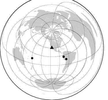
Nearby stations (2 deg radius)
| Station | Name | (Lat, Lon) | Start / End | Elevation |
| OBTO | Observatorio | (31.05, -115.46) | 1997-10-20 / 2499-01-01 | 2774 m |
| Crust2 Type: | M5,extended crust, 0.5 km seds. |
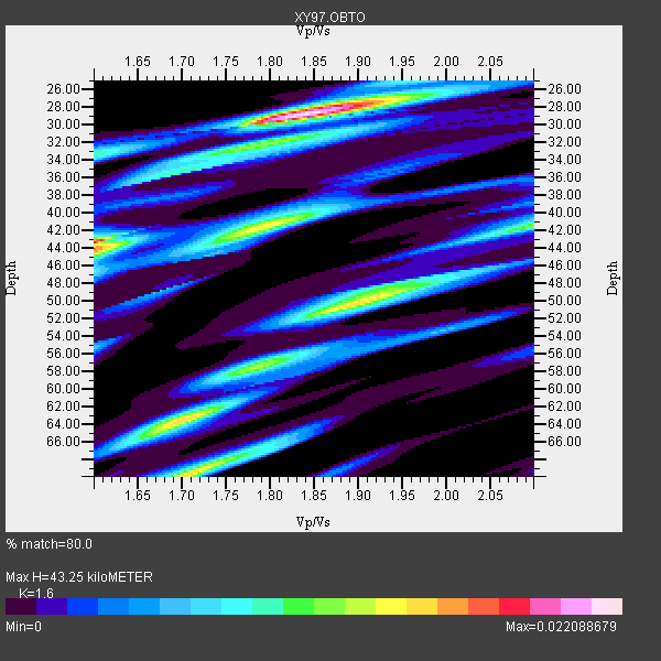
| Thickness Estimate: | 43 km |
| Thickness StdDev: | 12 km |
| Vp/Vs Estimate: | 1.60 |
| Vp/Vs StdDev: | 0.10 |
| Vs Estimate: | 3.922 km/s |
| Poisson's Ratio: | 0.18 |
| Peak Value: | 0.02 |
| Assumed Vp: | 6.276 km/s |
| Ps Weight: | 0.33333334 |
| PpPs Weight: | 0.33333334 |
| PsPs Weight: | 0.33333328 |
| Residual Complexity: | 0.911 |
| Nearby stations H: | +- |
| (2.0 deg) Vp/Vs: | +- |
1 with match > 90% ( 10.0 %) and 3 with match > 80% ( 30.0 %) out of 10.
Download stack as xyz text file.
Azimuth Distribution of Events:
Prior Results for this Station
| Study | Thickness | Vp/Vs | Vp | Vs | Poissons Ratio | Extra |
| EARS | 43 km | 1.60 | 6.276 km/s | 3.922 km/s | 0.18 | |
| Crust2.0 | 31 km | 1.78 | 6.276 km/s | 3.529 km/s | 0.27 | M5,extended crust, 0.5 km seds. |
| Global Maxima | 43 km | 1.60 | 6.276 km/s | 3.922 km/s | 0.18 | amp=0.022088679 |
| Local Maxima 1 | 29 km | 1.83 | 6.276 km/s | 3.425 km/s | 0.29 | amp=0.020614717 |
| Local Maxima 2 | 50 km | 1.89 | 6.276 km/s | 3.312 km/s | 0.31 | amp=0.015301036 |
| Local Maxima 3 | 70 km | 1.70 | 6.276 km/s | 3.686 km/s | 0.24 | amp=0.014984042 |
| Local Maxima 4 | 42 km | 1.79 | 6.276 km/s | 3.516 km/s | 0.27 | amp=0.013327087 |
| Predicted Arrivals for vertical incidence (zero ray parameter) | |
| Ps | 4.13 SECOND |
| PpPs | 17.92 SECOND |
| PsPs/PpSs | 22.05 SECOND |
Events Processed for this Station
Download zip of receiver functions as SAC
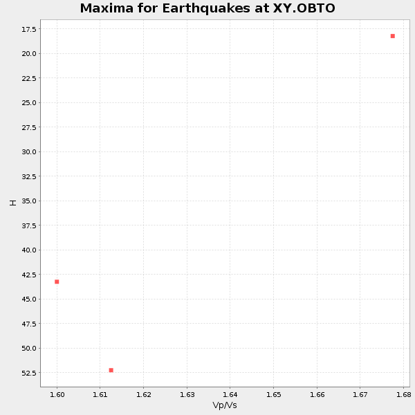
Plot maxima for each earthquake.
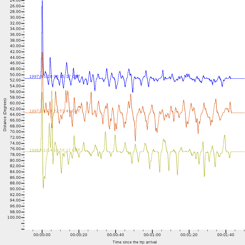
Events Used in the Stack
(3 events)| Radial Match | Distance | Baz | FERegion | Time | Lat/Lon | Depth | Magnitude |
| 93.617546 | 51.1 deg | 126.598 deg | Northern Peru | 1997/10/28 06:15:17 GMT | (-4.4, -76.7) | 112 km | 6.6 MB, 6.3 MS, 7.2 UNKNOWN, 6.6 ME |
| 87.61333 | 76.9 deg | 242.516 deg | Fiji Islands Region | 1998/01/14 19:56:12 GMT | (-15.8, -179.3) | 33 km | 5.3 MB, 5.7 MS |
| 84.90498 | 63.2 deg | 127.616 deg | Peru-Bolivia Border Region | 1997/11/28 22:53:41 GMT | (-13.7, -68.8) | 586 km | 6.4 MB, 6.6 UNKNOWN, 6.6 MW |
Losers
(7 events)| Radial Match | Distance | Baz | FERegion | Time | Lat/Lon | Depth | Magnitude | Reason |
| 79.773476 | 74.5 deg | 141.71 deg | Near Coast Of Central Chile | 1998/01/12 10:14:07 GMT | (-31.0, -71.4) | 35 km | 5.8 MB, 6.2 MS, 6.6 UNKNOWN, 6.2 ME | |
| 74.64081 | 88.0 deg | 296.674 deg | Volcano Islands, Japan Region | 1998/01/01 06:11:22 GMT | (23.9, 141.9) | 96 km | 6.4 MB, 5.8 MS, 6.8 UNKNOWN, 6.4 MW | |
| 72.66008 | 74.4 deg | 141.521 deg | Near Coast Of Central Chile | 1997/11/03 20:12:52 GMT | (-30.8, -71.3) | 45 km | 5.6 MB, 5.2 MD | |
| 68.723946 | 74.4 deg | 141.425 deg | Near Coast Of Central Chile | 1997/11/03 19:17:33 GMT | (-30.7, -71.2) | 45 km | 6.2 MB, 5.6 MS, 6.3 UNKNOWN, 5.8 MD | |
| 56.095737 | 78.5 deg | 311.526 deg | Hokkaido, Japan Region | 1998/01/30 15:50:13 GMT | (41.5, 142.0) | 33 km | 5.6 MB, 5.1 MS | |
| 47.933773 | 85.1 deg | 303.44 deg | Southeast Of Honshu, Japan | 1997/11/10 23:06:44 GMT | (31.2, 140.5) | 86 km | 5.8 MB, 6.1 UNKNOWN, 6.1 MW | |
| 47.10789 | 61.6 deg | 318.117 deg | Off East Coast Of Kamchatka | 1997/12/05 11:35:19 GMT | (53.9, 161.6) | 33 km | 5.7 MB |
