
Station YK PSMA - PSMA Santa Maria, Azores, Portugal
Network: YK00 - Coordinated Seismic Experiment in the Azores
Nearby stations (2 deg radius)
| Station | Name | (Lat, Lon) | Start / End | Elevation |
| PSMA | PSMA Santa Maria, Azores, Portugal | (36.99, -25.13) | 2000-12-15 / 2002-09-18 | 0.0 m |
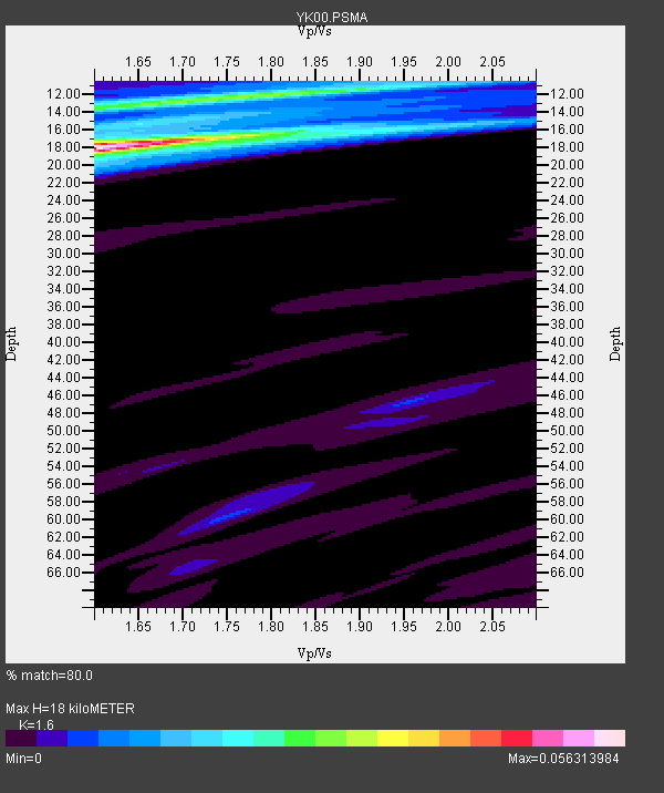
| Crust2 Type: | B0,melt affected o.c. and oceanic plateaus, 0.10 km seds. |
| Thickness Estimate: | 18 km |
| Thickness StdDev: | 4.5 km |
| Vp/Vs Estimate: | 1.60 |
| Vp/Vs StdDev: | 0.12 |
| Vs Estimate: | 3.001 km/s |
| Poisson's Ratio: | 0.18 |
| Peak Value: | 0.06 |
| Assumed Vp: | 4.802 km/s |
| Ps Weight: | 0.33333334 |
| PpPs Weight: | 0.33333334 |
| PsPs Weight: | 0.33333328 |
| Residual Complexity: | 0.550 |
| Nearby stations H: | +- |
| (2.0 deg) Vp/Vs: | +- |
7 with match > 90% ( 38.88889 %) and 12 with match > 80% ( 66.666664 %) out of 18.
Download stack as xyz text file.
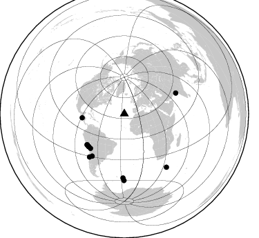
Azimuth Distribution of Events:
Prior Results for this Station
| Study | Thickness | Vp/Vs | Vp | Vs | Poissons Ratio | Extra |
| EARS | 18 km | 1.60 | 4.802 km/s | 3.001 km/s | 0.18 | |
| Crust2.0 | 16 km | 2.06 | 4.802 km/s | 2.335 km/s | 0.35 | B0,melt affected o.c. and oceanic plateaus, 0.10 km seds. |
| Global Maxima | 18 km | 1.60 | 4.802 km/s | 3.001 km/s | 0.18 | amp=0.056313984 |
| Local Maxima 1 | 12 km | 1.73 | 4.802 km/s | 2.784 km/s | 0.25 | amp=0.02899957 |
| Local Maxima 2 | 16 km | 1.81 | 4.802 km/s | 2.657 km/s | 0.28 | amp=0.013588723 |
| Local Maxima 3 | 16 km | 1.61 | 4.802 km/s | 2.978 km/s | 0.19 | amp=0.0091694305 |
| Local Maxima 4 | 20 km | 1.61 | 4.802 km/s | 2.978 km/s | 0.19 | amp=0.0070703053 |
| Predicted Arrivals for vertical incidence (zero ray parameter) | |
| Ps | 2.25 SECOND |
| PpPs | 9.75 SECOND |
| PsPs/PpSs | 12.00 SECOND |
Events Processed for this Station
Download zip of receiver functions as SAC
Plot maxima for each earthquake.
Events Used in the Stack
(12 events)| Radial Match | Distance | Baz | FERegion | Time | Lat/Lon | Depth | Magnitude |
| 99.99998 | 92.7 deg | 181.237 deg | South Sandwich Islands Region | 2002/03/09 12:27:11 GMT | (-56.0, -27.3) | 118 km | 5.8 MB, 6.0 MW, 6.0 MW |
| 99.98702 | 98.2 deg | 141.692 deg | Prince Edward Islands Region | 2002/03/17 19:33:33 GMT | (-45.2, 35.1) | 10 km | 5.5 MB, 5.7 MS, 6.0 MW, 6.0 MW |
| 95.197586 | 69.8 deg | 224.423 deg | Northern Chile | 2002/01/14 15:36:26 GMT | (-19.4, -69.2) | 33 km | 5.5 MB, 5.2 MS, 5.8 MW, 5.7 MW |
| 95.136856 | 70.0 deg | 229.981 deg | Near Coast Of Peru | 2001/06/23 20:33:14 GMT | (-16.3, -73.6) | 33 km | 6.7 MB, 8.2 MS, 8.4 MW, 7.8 ME |
| 94.6746 | 70.0 deg | 227.892 deg | Near Coast Of Peru | 2001/07/07 09:38:43 GMT | (-17.5, -72.1) | 33 km | 6.6 MB, 7.3 MS, 7.6 MW, 7.5 ME |
| 94.40377 | 61.2 deg | 264.718 deg | El Salvador | 2001/01/13 17:33:32 GMT | (13.0, -88.7) | 60 km | 6.4 MB, 7.8 MS, 7.7 MW, 7.5 ME |
| 94.26146 | 80.3 deg | 68.089 deg | Southern India | 2001/01/26 03:16:40 GMT | (23.4, 70.2) | 16 km | 6.9 MB, 8.0 MS, 7.7 MW, 7.7 ME |
| 88.54573 | 76.8 deg | 217.292 deg | La Rioja Province, Argentina | 2001/04/21 18:15:46 GMT | (-29.1, -67.5) | 128 km | 5.3 MB, 5.8 MW, 5.2 MD |
| 86.277405 | 80.0 deg | 218.93 deg | Near Coast Of Central Chile | 2002/06/18 13:56:22 GMT | (-30.8, -71.1) | 54 km | 6.0 MB, 6.6 MW, 6.4 MW |
| 85.63171 | 69.9 deg | 227.418 deg | Near Coast Of Peru | 2001/06/26 04:18:31 GMT | (-17.7, -71.6) | 24 km | 6.2 MB, 6.7 MS, 6.8 MW, 6.7 ME |
| 85.40522 | 96.4 deg | 180.232 deg | South Sandwich Islands Region | 2001/04/13 15:33:53 GMT | (-59.7, -25.6) | 26 km | 5.3 MB, 6.0 MS, 6.2 MW, 6.2 MW |
| 81.2698 | 70.0 deg | 230.374 deg | Near Coast Of Peru | 2001/07/05 13:53:48 GMT | (-16.1, -74.0) | 62 km | 6.2 MB, 6.6 MW, 6.5 ME |
Losers
(6 events)| Radial Match | Distance | Baz | FERegion | Time | Lat/Lon | Depth | Magnitude | Reason |
| 78.708015 | 30.2 deg | 5.218 deg | Iceland Region | 2002/09/16 18:48:26 GMT | (66.9, -18.5) | 10 km | 5.5 MB, 5.7 MS, 5.8 MW, 5.8 MW | |
| 75.242424 | 58.3 deg | 67.094 deg | Western Iran | 2002/06/22 02:58:21 GMT | (35.6, 49.0) | 10 km | 6.2 MB, 6.4 MS, 6.5 MW, 6.5 MW | |
| 62.740322 | 76.4 deg | 216.842 deg | Catamarca Province, Argentina | 2002/05/28 04:04:22 GMT | (-28.9, -66.8) | 22 km | 6.0 MB, 5.7 MS, 6.0 MW, 5.9 MW | |
| 60.67666 | 95.5 deg | 17.546 deg | Northeastern China | 2002/09/15 08:39:32 GMT | (44.8, 129.9) | 586 km | 5.8 MB, 6.4 MW, 6.4 MW | |
| 54.44263 | 94.5 deg | 178.988 deg | South Sandwich Islands Region | 2002/07/30 06:55:07 GMT | (-57.9, -23.2) | 33 km | 5.7 MB, 5.8 MS, 6.2 MW, 6.0 MW | |
| 53.144783 | 72.6 deg | 172.398 deg | Southern Mid-Atlantic Ridge | 2002/08/04 15:16:26 GMT | (-35.5, -16.2) | 10 km | 6.0 MW, 5.3 MS, 5.4 MB, 5.9 MW |
