
Station XA SA77 - XA.SA77
Network: XA97 - Anatomy of an Archean Craton, South Africa
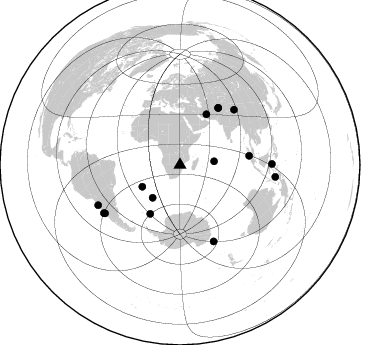
Nearby stations (2 deg radius)
| Station | Name | (Lat, Lon) | Start / End | Elevation |
| SA77 | XA.SA77 | (-20.76, 30.92) | 1997-04-13 / 1999-12-31 | 576 m |
| Crust2 Type: | I1,late Proter., no seds. |
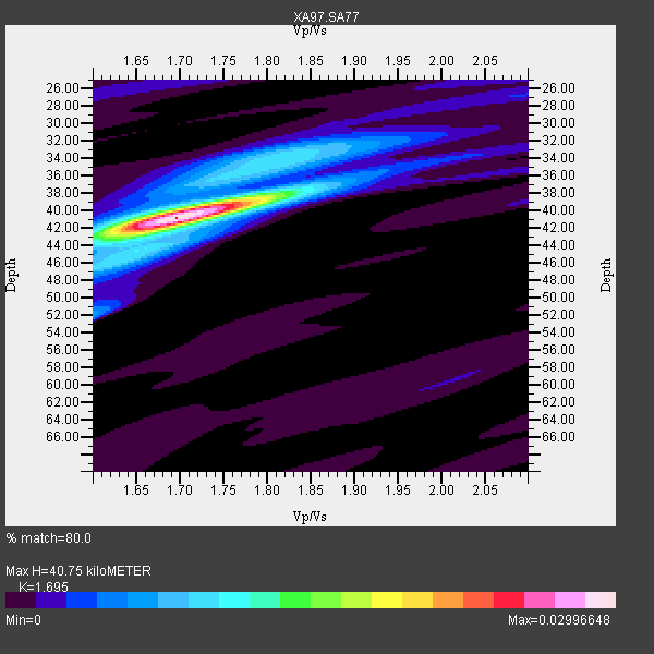
| Thickness Estimate: | 41 km |
| Thickness StdDev: | 0.3 km |
| Vp/Vs Estimate: | 1.70 |
| Vp/Vs StdDev: | 0.01 |
| Vs Estimate: | 3.919 km/s |
| Poisson's Ratio: | 0.23 |
| Peak Value: | 0.03 |
| Assumed Vp: | 6.642 km/s |
| Ps Weight: | 0.33333334 |
| PpPs Weight: | 0.33333334 |
| PsPs Weight: | 0.33333328 |
| Residual Complexity: | 0.384 |
| Nearby stations H: | +- |
| (2.0 deg) Vp/Vs: | +- |
9 with match > 90% ( 32.142857 %) and 15 with match > 80% ( 53.57143 %) out of 28.
Download stack as xyz text file.
Azimuth Distribution of Events:
Prior Results for this Station
| Study | Thickness | Vp/Vs | Vp | Vs | Poissons Ratio | Extra |
| EARS | 41 km | 1.70 | 6.642 km/s | 3.919 km/s | 0.23 | |
| Crust2.0 | 43 km | 1.77 | 6.642 km/s | 3.756 km/s | 0.26 | I1,late Proter., no seds. |
| Global Maxima | 41 km | 1.70 | 6.642 km/s | 3.919 km/s | 0.23 | amp=0.02996648 |
| Local Maxima 1 | 34 km | 1.82 | 6.642 km/s | 3.659 km/s | 0.28 | amp=0.0090220645 |
| Local Maxima 2 | 38 km | 1.79 | 6.642 km/s | 3.721 km/s | 0.27 | amp=0.006905208 |
| Local Maxima 3 | 52 km | 1.60 | 6.642 km/s | 4.151 km/s | 0.18 | amp=0.006384139 |
| Local Maxima 4 | 43 km | 1.64 | 6.642 km/s | 4.044 km/s | 0.21 | amp=0.0055476394 |
| Predicted Arrivals for vertical incidence (zero ray parameter) | |
| Ps | 4.26 SECOND |
| PpPs | 16.53 SECOND |
| PsPs/PpSs | 20.80 SECOND |
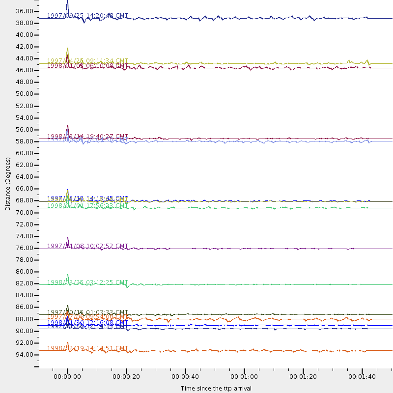
Events Processed for this Station
Download zip of receiver functions as SAC
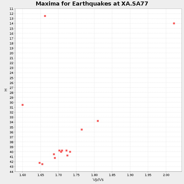
Plot maxima for each earthquake.
Events Used in the Stack
(15 events)| Radial Match | Distance | Baz | FERegion | Time | Lat/Lon | Depth | Magnitude |
| 98.728226 | 83.8 deg | 156.126 deg | Balleny Islands Region | 1998/03/25 03:12:25 GMT | (-62.9, 149.5) | 10 km | 6.6 MB, 8.0 MS, 8.3 UNKNOWN, 8.1 MW |
| 98.23483 | 89.4 deg | 237.153 deg | Near Coast Of Central Chile | 1997/10/15 01:03:33 GMT | (-30.9, -71.2) | 58 km | 6.8 MB, 6.8 MS, 7.3 UNKNOWN, 7.1 MW |
| 97.78037 | 77.1 deg | 44.504 deg | Xizang | 1997/11/08 10:02:52 GMT | (35.1, 87.3) | 33 km | 6.2 MB, 7.9 MS, 7.7 UNKNOWN, 7.6 MW |
| 97.39013 | 91.3 deg | 243.924 deg | Near Coast Of Northern Chile | 1998/01/30 12:16:08 GMT | (-23.9, -70.2) | 42 km | 6.3 MB, 6.5 MS, 7.0 UNKNOWN, 6.7 ME |
| 97.05804 | 69.6 deg | 82.57 deg | Southern Sumatra, Indonesia | 1998/04/01 17:56:23 GMT | (-0.5, 99.3) | 56 km | 6.2 MB, 6.9 MS, 7.0 UNKNOWN, 6.6 ME |
| 95.40436 | 91.9 deg | 89.416 deg | Minahassa Peninsula, Sulawesi | 1997/11/25 12:14:33 GMT | (1.2, 122.5) | 24 km | 6.1 MB, 6.8 MS, 7.1 UNKNOWN, 6.7 ME |
| 94.693794 | 68.4 deg | 33.992 deg | Afghanistan-Tajikistan Bord Reg. | 1998/02/20 12:18:06 GMT | (36.5, 71.1) | 236 km | 5.8 MB, 5.7 MS, 6.4 UNKNOWN, 6.3 MW |
| 94.55971 | 56.8 deg | 27.716 deg | Northern And Central Iran | 1998/03/14 19:40:27 GMT | (30.2, 57.6) | 9.0 km | 5.9 MB, 6.9 MS, 6.6 UNKNOWN, 6.3 ME |
| 93.6013 | 68.3 deg | 33.946 deg | Hindu Kush Region, Afghanistan | 1997/05/13 14:13:45 GMT | (36.4, 70.9) | 196 km | 6.1 MB, 6.5 UNKNOWN, 6.4 MW |
| 88.47568 | 90.2 deg | 237.722 deg | Near Coast Of Central Chile | 1997/07/06 09:54:00 GMT | (-30.1, -71.9) | 19 km | 5.8 MB, 6.5 MS, 6.8 UNKNOWN, 6.4 ME |
| 86.09539 | 57.3 deg | 211.447 deg | South Sandwich Islands Region | 1997/10/05 18:04:30 GMT | (-59.7, -29.2) | 274 km | 6.0 MB, 6.3 UNKNOWN, 6.3 MW |
| 85.57162 | 42.8 deg | 220.085 deg | Southern Mid-Atlantic Ridge | 1997/04/25 09:11:34 GMT | (-48.3, -10.0) | 10 km | 5.8 MS, 5.3 MB, 5.8 UNKNOWN, 5.7 MW |
| 85.34949 | 34.4 deg | 84.099 deg | Mid-Indian Ridge | 1997/09/25 14:20:48 GMT | (-13.8, 66.2) | 10 km | 5.3 MB, 5.7 MS, 6.0 UNKNOWN, 6.0 MW |
| 80.9488 | 43.7 deg | 240.019 deg | Southern Mid-Atlantic Ridge | 1998/01/03 06:10:08 GMT | (-35.5, -16.2) | 10 km | 5.9 MS, 5.4 MB, 6.3 UNKNOWN, 6.1 MW |
| 80.838554 | 96.0 deg | 97.071 deg | Banda Sea | 1998/02/19 14:14:51 GMT | (-4.5, 129.1) | 33 km | 6.1 MB, 6.4 MS, 6.5 UNKNOWN, 6.5 MW |
Losers
(13 events)| Radial Match | Distance | Baz | FERegion | Time | Lat/Lon | Depth | Magnitude | Reason |
| 76.68078 | 78.6 deg | 91.793 deg | Java Sea | 1997/07/11 09:55:12 GMT | (-5.7, 110.8) | 574 km | 5.6 MB | |
| 76.44793 | 79.8 deg | 317.573 deg | Azores Islands, Portugal | 1997/06/27 04:39:52 GMT | (38.3, -26.7) | 10 km | 5.6 MB, 5.4 MS, 5.9 UNKNOWN, 5.9 MW | |
| 72.38574 | 58.8 deg | 350.475 deg | Ionian Sea | 1997/11/18 13:07:41 GMT | (37.6, 20.7) | 33 km | 5.9 MB, 6.4 MS, 6.7 UNKNOWN, 6.1 ML | |
| 71.25798 | 89.5 deg | 241.2 deg | Northern Chile | 1997/05/17 02:10:18 GMT | (-27.2, -69.5) | 106 km | 5.5 MB, 5.6 UNKNOWN, 5.5 MW | |
| 68.54863 | 90.4 deg | 245.935 deg | Northern Chile | 1997/09/28 23:13:13 GMT | (-22.4, -68.4) | 107 km | 5.7 MB, 5.6 UNKNOWN, 5.6 MW | |
| 68.22113 | 90.4 deg | 238.495 deg | Near Coast Of Central Chile | 1997/07/19 12:22:57 GMT | (-29.3, -71.7) | 26 km | 5.8 MB, 5.5 MS, 5.9 UNKNOWN, 5.8 MW | |
| 63.490715 | 36.3 deg | 82.426 deg | Mid-Indian Ridge | 1998/04/09 23:26:52 GMT | (-12.2, 67.8) | 10 km | 5.5 MB, 5.4 MS, 5.9 UNKNOWN, 5.9 MW | |
| 62.49947 | 96.9 deg | 99.756 deg | Banda Sea | 1997/07/31 21:54:21 GMT | (-6.6, 130.9) | 59 km | 5.9 MB, 5.3 MS, 6.1 UNKNOWN, 6.1 MW | |
| 61.361217 | 97.9 deg | 82.535 deg | Mindanao, Philippines | 1997/10/06 12:30:05 GMT | (9.8, 125.8) | 106 km | 5.9 MB, 6.5 UNKNOWN, 6.4 MW | |
| 58.56005 | 96.2 deg | 96.733 deg | Banda Sea | 1998/01/13 09:50:11 GMT | (-4.1, 129.1) | 44 km | 5.9 MB, 5.5 MS, 5.9 UNKNOWN, 5.8 MW | |
| 52.248257 | 94.0 deg | 253.782 deg | Peru-Bolivia Border Region | 1997/11/28 22:53:41 GMT | (-13.7, -68.8) | 586 km | 6.4 MB, 6.6 UNKNOWN, 6.6 MW | |
| 51.58703 | 91.2 deg | 247.96 deg | Chile-Bolivia Border Region | 1997/12/09 14:23:45 GMT | (-20.2, -68.4) | 133 km | 5.7 MB, 5.7 UNKNOWN, 5.7 MW | |
| 36.366524 | 89.5 deg | 237.04 deg | Near Coast Of Central Chile | 1998/01/12 10:14:07 GMT | (-31.0, -71.4) | 35 km | 5.8 MB, 6.2 MS, 6.6 UNKNOWN, 6.2 ME |
