
Station XC Y01 - Y01
Network: XC00 - Yellowstone Intermountain Seismic Array
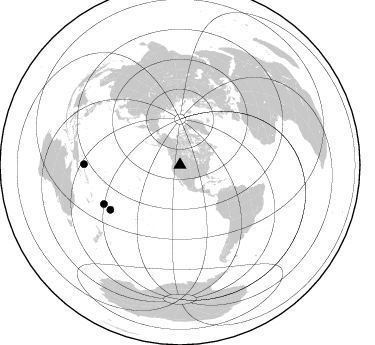
Nearby stations (2 deg radius)
| Station | Name | (Lat, Lon) | Start / End | Elevation |
| Y01 | Y01 | (44.39, -113.17) | 2000-06-27 / 2001-12-31 | 2099 m |
| Crust2 Type: | H3,early/mid Proter. shield, Finland, 0.5 km seds. |
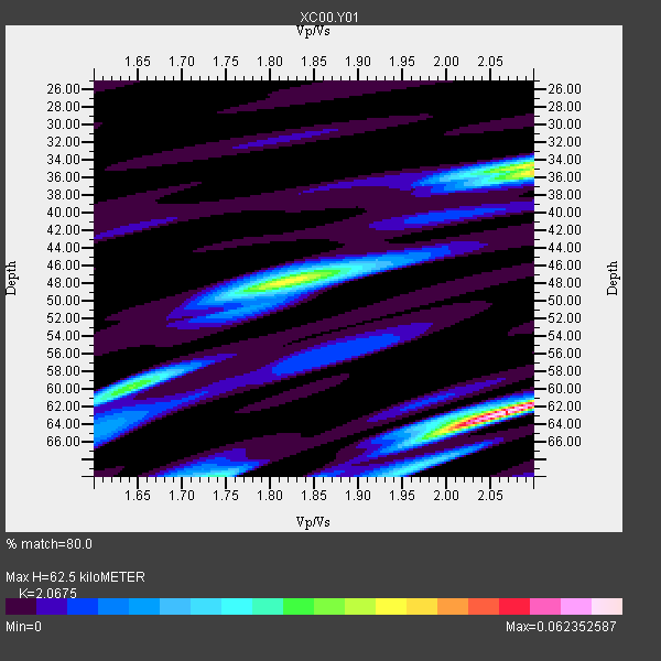
| Thickness Estimate: | 62 km |
| Thickness StdDev: | 13 km |
| Vp/Vs Estimate: | 2.07 |
| Vp/Vs StdDev: | 0.09 |
| Vs Estimate: | 3.181 km/s |
| Poisson's Ratio: | 0.35 |
| Peak Value: | 0.06 |
| Assumed Vp: | 6.577 km/s |
| Ps Weight: | 0.33333334 |
| PpPs Weight: | 0.33333334 |
| PsPs Weight: | 0.33333328 |
| Residual Complexity: | 0.781 |
| Nearby stations H: | +- |
| (2.0 deg) Vp/Vs: | +- |
0 with match > 90% ( 0.0 %) and 3 with match > 80% ( 100.0 %) out of 3.
Download stack as xyz text file.
Azimuth Distribution of Events:
Prior Results for this Station
| Study | Thickness | Vp/Vs | Vp | Vs | Poissons Ratio | Extra |
| EARS | 62 km | 2.07 | 6.577 km/s | 3.181 km/s | 0.35 | |
| Crust2.0 | 46 km | 1.78 | 6.577 km/s | 3.701 km/s | 0.27 | H3,early/mid Proter. shield, Finland, 0.5 km seds. |
| Global Maxima | 62 km | 2.07 | 6.577 km/s | 3.181 km/s | 0.35 | amp=0.062352587 |
| Local Maxima 1 | 35 km | 2.10 | 6.577 km/s | 3.136 km/s | 0.35 | amp=0.041870452 |
| Local Maxima 2 | 48 km | 1.82 | 6.577 km/s | 3.624 km/s | 0.28 | amp=0.038185883 |
| Local Maxima 3 | 34 km | 2.10 | 6.577 km/s | 3.136 km/s | 0.35 | amp=0.02130326 |
| Local Maxima 4 | 65 km | 1.99 | 6.577 km/s | 3.305 km/s | 0.33 | amp=0.01716105 |
| Predicted Arrivals for vertical incidence (zero ray parameter) | |
| Ps | 10.14 SECOND |
| PpPs | 29.15 SECOND |
| PsPs/PpSs | 39.29 SECOND |
Events Processed for this Station
Download zip of receiver functions as SAC
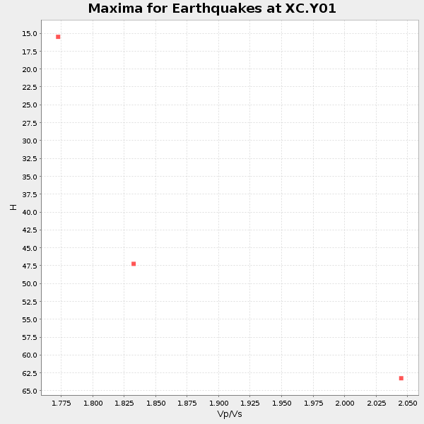
Plot maxima for each earthquake.
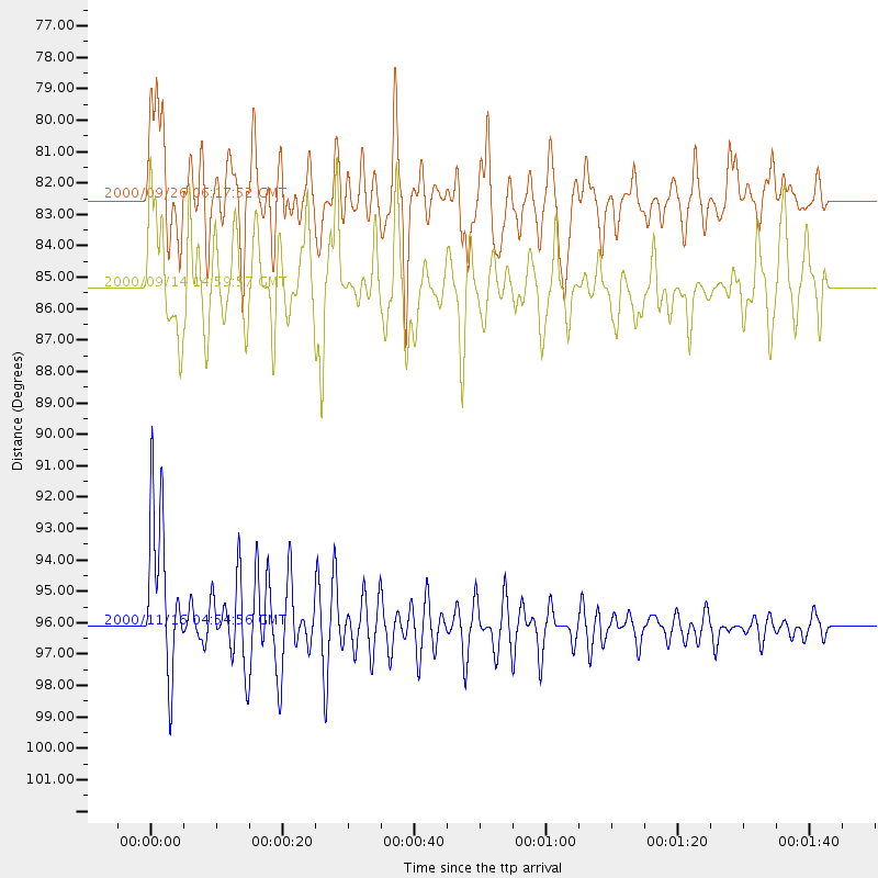
Events Used in the Stack
(3 events)| Radial Match | Distance | Baz | FERegion | Time | Lat/Lon | Depth | Magnitude |
| 88.37873 | 96.1 deg | 270.411 deg | New Ireland Region, P.N.G. | 2000/11/16 04:54:56 GMT | (-4.0, 152.2) | 33 km | 6.0 MB, 8.2 MS, 8.0 MW, 8.0 ME |
| 85.617744 | 82.5 deg | 237.279 deg | Tonga Islands | 2000/09/26 06:17:52 GMT | (-17.2, -173.9) | 56 km | 6.1 MB, 6.1 MS, 6.4 MW, 6.1 ME |
| 81.773796 | 85.3 deg | 242.822 deg | Fiji Islands | 2000/09/14 14:59:57 GMT | (-15.7, 179.8) | 33 km | 5.7 MB, 6.2 MS, 6.3 MW, 6.2 MW |
Losers
(0 events)| Radial Match | Distance | Baz | FERegion | Time | Lat/Lon | Depth | Magnitude | Reason |
