
Station XC Y47 - Y47
Network: XC00 - Yellowstone Intermountain Seismic Array
Nearby stations (2 deg radius)
| Station | Name | (Lat, Lon) | Start / End | Elevation |
| Y47 | Y47 | (45.99, -110.04) | 2000-07-09 / 2001-12-31 | 1644 m |
| Crust2 Type: | P6,orogen/43km, Orogen, 0.5 km seds. |
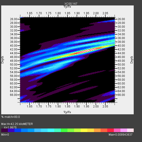
| Thickness Estimate: | 42 km |
| Thickness StdDev: | 6.4 km |
| Vp/Vs Estimate: | 1.97 |
| Vp/Vs StdDev: | 0.13 |
| Vs Estimate: | 3.227 km/s |
| Poisson's Ratio: | 0.33 |
| Peak Value: | 0.01 |
| Assumed Vp: | 6.35 km/s |
| Ps Weight: | 0.33333334 |
| PpPs Weight: | 0.33333334 |
| PsPs Weight: | 0.33333328 |
| Residual Complexity: | 0.600 |
| Nearby stations H: | +- |
| (2.0 deg) Vp/Vs: | +- |
3 with match > 90% ( 23.076923 %) and 13 with match > 80% ( 100.0 %) out of 13.
Download stack as xyz text file.
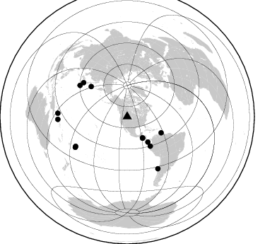
Azimuth Distribution of Events:
Prior Results for this Station
| Study | Thickness | Vp/Vs | Vp | Vs | Poissons Ratio | Extra |
| EARS | 42 km | 1.97 | 6.35 km/s | 3.227 km/s | 0.33 | |
| Crust2.0 | 43 km | 1.76 | 6.35 km/s | 3.609 km/s | 0.26 | P6,orogen/43km, Orogen, 0.5 km seds. |
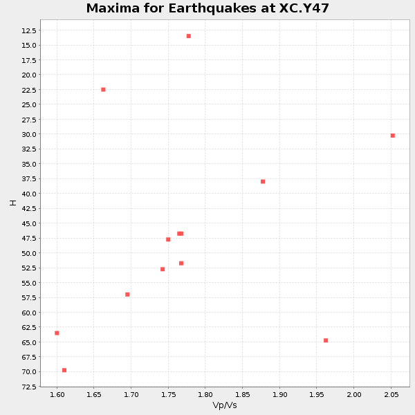
| Global Maxima | 42 km | 1.97 | 6.35 km/s | 3.227 km/s | 0.33 | amp=0.008943837 |
| Local Maxima 1 | 46 km | 1.81 | 6.35 km/s | 3.518 km/s | 0.28 | amp=0.004383849 |
| Local Maxima 2 | 36 km | 1.97 | 6.35 km/s | 3.223 km/s | 0.33 | amp=0.0030439238 |
| Local Maxima 3 | 40 km | 2.07 | 6.35 km/s | 3.068 km/s | 0.35 | amp=0.0027422402 |
| Local Maxima 4 | 38 km | 2.04 | 6.35 km/s | 3.117 km/s | 0.34 | amp=0.0023843911 |
| Predicted Arrivals for vertical incidence (zero ray parameter) | |
| Ps | 6.44 SECOND |
| PpPs | 19.74 SECOND |
| PsPs/PpSs | 26.18 SECOND |
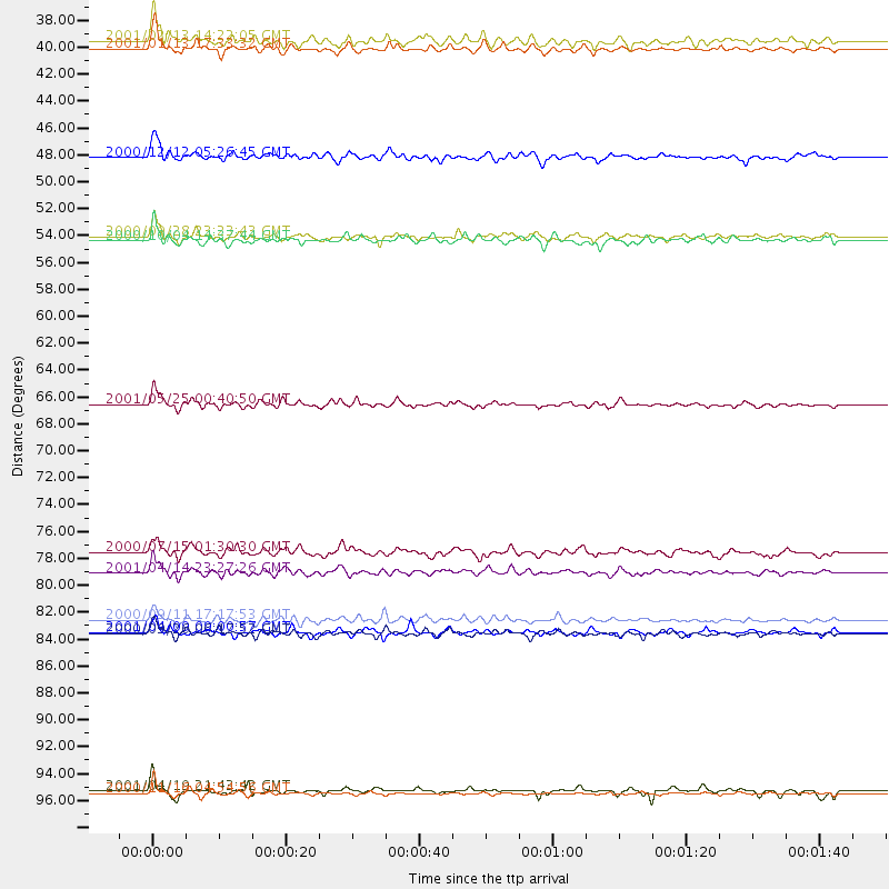
Events Processed for this Station
Download zip of receiver functions as SAC
Plot maxima for each earthquake.
Events Used in the Stack
(13 events)| Radial Match | Distance | Baz | FERegion | Time | Lat/Lon | Depth | Magnitude |
| 92.66491 | 66.5 deg | 309.886 deg | Kuril Islands | 2001/05/25 00:40:50 GMT | (44.3, 148.4) | 33 km | 6.1 MB, 6.7 MS, 6.7 MW, 6.6 MW |
| 92.09014 | 37.5 deg | 144.284 deg | El Salvador | 2001/01/13 17:33:32 GMT | (13.0, -88.7) | 60 km | 6.4 MB, 7.8 MS, 7.7 MW, 7.5 ME |
| 90.77845 | 85.2 deg | 239.465 deg | Tonga Islands | 2000/09/26 06:17:52 GMT | (-17.2, -173.9) | 56 km | 6.1 MB, 6.1 MS, 6.4 MW, 6.1 ME |
| 86.96476 | 98.3 deg | 272.83 deg | New Ireland Region, P.N.G. | 2000/11/16 04:54:56 GMT | (-4.0, 152.2) | 33 km | 6.0 MB, 8.2 MS, 8.0 MW, 8.0 ME |
| 86.63387 | 52.8 deg | 141.881 deg | Near Coast Of Ecuador | 2000/09/28 23:23:43 GMT | (-0.2, -80.6) | 23 km | 5.8 MB, 6.0 MS, 6.6 MW, 6.4 MW |
| 85.91738 | 46.3 deg | 140.809 deg | South Of Panama | 2000/12/12 05:26:45 GMT | (6.0, -82.7) | 10 km | 5.8 MB, 5.7 MS, 6.3 ME, 6.1 MW |
| 85.76134 | 85.1 deg | 149.426 deg | Off Coast Of Central Chile | 2001/04/09 09:00:57 GMT | (-32.7, -73.1) | 11 km | 6.1 MB, 6.3 MS, 6.7 MW, 6.3 ME |
| 85.05798 | 84.1 deg | 240.104 deg | Tonga Islands | 2000/09/11 17:17:53 GMT | (-15.9, -173.7) | 115 km | 6.0 MB, 6.3 MW, 6.3 MW |
| 84.86986 | 98.1 deg | 267.767 deg | Solomon Islands | 2001/04/19 21:43:42 GMT | (-7.4, 155.9) | 17 km | 6.0 MB, 6.6 MS, 6.7 MW, 6.2 ME |
| 82.7536 | 36.8 deg | 144.262 deg | El Salvador | 2001/02/13 14:22:05 GMT | (13.7, -88.9) | 10 km | 5.5 MB, 6.5 MS, 6.6 MW, 6.1 MD |
| 81.971466 | 80.3 deg | 303.344 deg | Southeast Of Honshu, Japan | 2001/04/14 23:27:26 GMT | (30.1, 141.8) | 10 km | 6.0 MB, 5.8 MS, 6.0 MW, 6.0 ME |
| 81.17411 | 53.1 deg | 115.295 deg | Windward Islands | 2000/10/04 14:37:44 GMT | (11.1, -62.6) | 110 km | 5.6 MB, 5.4 MS, 6.1 MW, 5.9 MD |
| 80.69654 | 78.6 deg | 307.819 deg | Near S. Coast Of Honshu, Japan | 2000/07/15 01:30:30 GMT | (34.3, 139.3) | 10 km | 5.5 MB, 5.9 MS, 6.1 MW, 6.0 MW |
Losers
(0 events)| Radial Match | Distance | Baz | FERegion | Time | Lat/Lon | Depth | Magnitude | Reason |
