
Station XL S111 - Milepost 18
Network: XL97 - Deep Probe (Archean-Proterozoic)
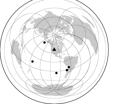
Nearby stations (2 deg radius)
| Station | Name | (Lat, Lon) | Start / End | Elevation |
| S111 | Milepost 18 | (41.54, -108.85) | 1997-05-16 / 1997-12-31 | 2092 m |
| Crust2 Type: | Q4,orogen/43km no ice, Tethian Belt, 5 km seds. |
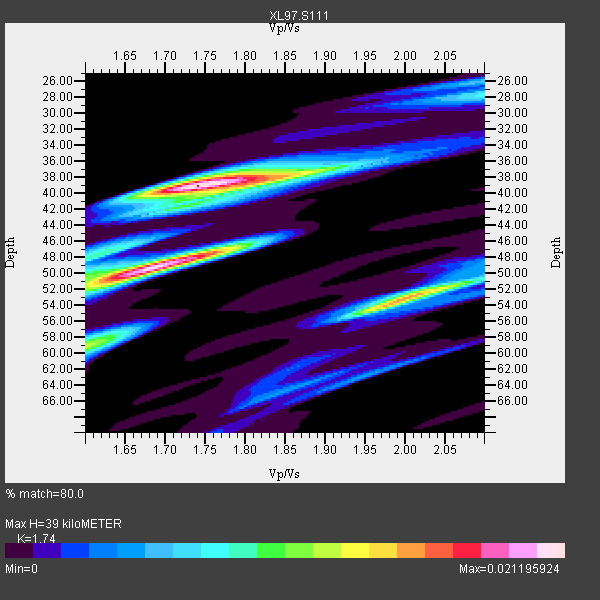
| Thickness Estimate: | 39 km |
| Thickness StdDev: | 7.1 km |
| Vp/Vs Estimate: | 1.74 |
| Vp/Vs StdDev: | 0.10 |
| Vs Estimate: | 3.567 km/s |
| Poisson's Ratio: | 0.25 |
| Peak Value: | 0.02 |
| Assumed Vp: | 6.207 km/s |
| Ps Weight: | 0.33333334 |
| PpPs Weight: | 0.33333334 |
| PsPs Weight: | 0.33333328 |
| Residual Complexity: | 0.737 |
| Nearby stations H: | +- |
| (2.0 deg) Vp/Vs: | +- |
1 with match > 90% ( 9.090909 %) and 6 with match > 80% ( 54.545456 %) out of 11.
Download stack as xyz text file.
Azimuth Distribution of Events:
Prior Results for this Station
| Study | Thickness | Vp/Vs | Vp | Vs | Poissons Ratio | Extra |
| EARS | 39 km | 1.74 | 6.207 km/s | 3.567 km/s | 0.25 | |
| Crust2.0 | 43 km | 1.76 | 6.207 km/s | 3.535 km/s | 0.26 | Q4,orogen/43km no ice, Tethian Belt, 5 km seds. |
| Global Maxima | 39 km | 1.74 | 6.207 km/s | 3.567 km/s | 0.25 | amp=0.021195924 |
| Local Maxima 1 | 49 km | 1.68 | 6.207 km/s | 3.689 km/s | 0.23 | amp=0.020758089 |
| Local Maxima 2 | 53 km | 2.01 | 6.207 km/s | 3.092 km/s | 0.33 | amp=0.015800875 |
| Local Maxima 3 | 59 km | 1.61 | 6.207 km/s | 3.849 km/s | 0.19 | amp=0.010378495 |
| Local Maxima 4 | 38 km | 1.83 | 6.207 km/s | 3.401 km/s | 0.29 | amp=0.008466932 |
| Predicted Arrivals for vertical incidence (zero ray parameter) | |
| Ps | 4.65 SECOND |
| PpPs | 17.22 SECOND |
| PsPs/PpSs | 21.87 SECOND |
Events Processed for this Station
Download zip of receiver functions as SAC
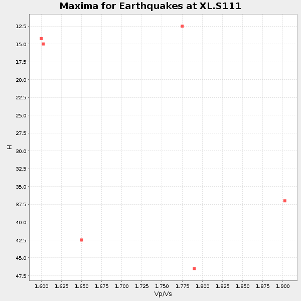
Plot maxima for each earthquake.
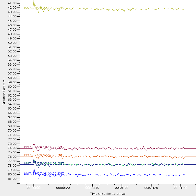
Events Used in the Stack
(6 events)| Radial Match | Distance | Baz | FERegion | Time | Lat/Lon | Depth | Magnitude |
| 93.932495 | 79.4 deg | 148.118 deg | Near Coast Of Central Chile | 1997/07/27 05:21:29 GMT | (-30.5, -71.9) | 33 km | 5.6 MB, 5.8 MS, 6.3 UNKNOWN, 6.2 MW |
| 88.66202 | 40.4 deg | 306.426 deg | Fox Islands, Aleutian Islands | 1997/07/20 00:30:20 GMT | (52.6, -167.5) | 14 km | 5.6 MB, 5.9 MS, 6.2 UNKNOWN, 6.2 MW |
| 88.13804 | 75.3 deg | 139.897 deg | Jujuy Province, Argentina | 1997/07/20 10:14:22 GMT | (-23.0, -66.3) | 256 km | 5.7 MB, 6.1 UNKNOWN, 5.7 ME |
| 85.7301 | 79.3 deg | 148.127 deg | Near Coast Of Central Chile | 1997/07/25 06:47:02 GMT | (-30.5, -71.9) | 33 km | 5.6 MB, 5.5 MS, 6.3 UNKNOWN |
| 84.78335 | 82.0 deg | 241.627 deg | Tonga Islands | 1997/05/27 08:00:29 GMT | (-15.2, -173.3) | 14 km | 5.6 MB, 6.3 MS, 6.4 UNKNOWN, 5.7 ME |
| 84.52386 | 77.3 deg | 174.734 deg | Southern Pacific Ocean | 1997/05/29 17:02:38 GMT | (-36.0, -102.5) | 10 km | 5.6 MB, 6.1 MS, 6.5 UNKNOWN, 6.4 MW |
Losers
(5 events)| Radial Match | Distance | Baz | FERegion | Time | Lat/Lon | Depth | Magnitude | Reason |
| 78.89244 | 78.4 deg | 147.399 deg | Near Coast Of Central Chile | 1997/07/19 12:22:57 GMT | (-29.3, -71.7) | 26 km | 5.8 MB, 5.5 MS, 5.9 UNKNOWN, 5.8 MW | |
| 76.91781 | 90.6 deg | 292.426 deg | Mariana Islands | 1997/05/27 15:09:03 GMT | (16.3, 145.4) | 536 km | 5.5 MB, 5.6 UNKNOWN, 5.6 MW | |
| 71.4939 | 97.5 deg | 249.436 deg | Vanuatu Islands | 1997/05/21 14:10:26 GMT | (-20.4, 169.3) | 57 km | 5.9 MB, 6.5 MS, 6.7 UNKNOWN, 6.1 ME | |
| 69.99252 | 79.2 deg | 148.073 deg | Near Coast Of Central Chile | 1997/07/21 23:19:39 GMT | (-30.3, -71.9) | 33 km | 5.2 MB, 5.5 MS, 6.1 UNKNOWN | |
| 49.87549 | 77.5 deg | 144.638 deg | Northern Chile | 1997/05/17 02:10:18 GMT | (-27.2, -69.5) | 106 km | 5.5 MB, 5.6 UNKNOWN, 5.5 MW |
