
Station XR FA17 - fled station 17
Network: XR01 - Florida to Edmonton Seismic Experiment
Nearby stations (2 deg radius)
| Station | Name | (Lat, Lon) | Start / End | Elevation |
| FA17 | fled station 17 | (42.03, -94.84) | 2001-05-25 / 2002-12-31 | 0.4 km |
| Crust2 Type: | DE,thick Platform 1 km seds. |
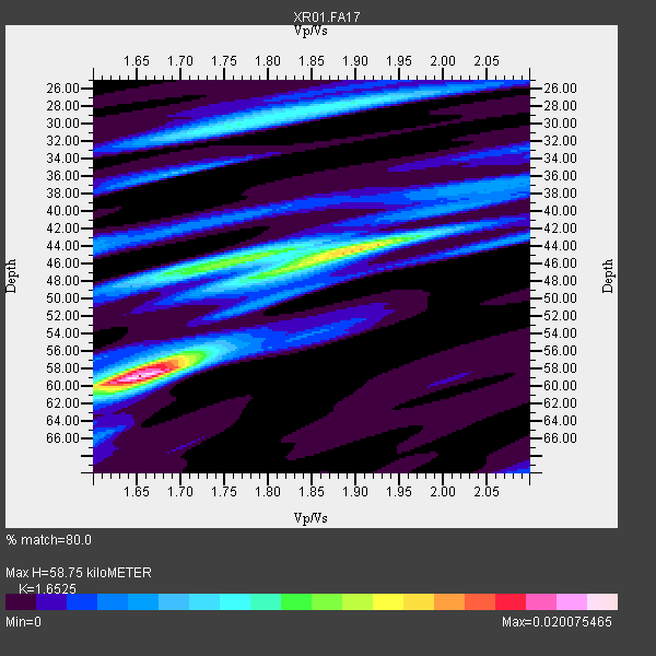
| Thickness Estimate: | 59 km |
| Thickness StdDev: | 6.6 km |
| Vp/Vs Estimate: | 1.65 |
| Vp/Vs StdDev: | 0.08 |
| Vs Estimate: | 3.952 km/s |
| Poisson's Ratio: | 0.21 |
| Peak Value: | 0.02 |
| Assumed Vp: | 6.53 km/s |
| Ps Weight: | 0.33333334 |
| PpPs Weight: | 0.33333334 |
| PsPs Weight: | 0.33333328 |
| Residual Complexity: | 0.769 |
| Nearby stations H: | +- |
| (2.0 deg) Vp/Vs: | +- |
7 with match > 90% ( 63.636364 %) and 11 with match > 80% ( 100.0 %) out of 11.
Download stack as xyz text file.
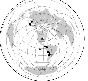
Azimuth Distribution of Events:
Prior Results for this Station
| Study | Thickness | Vp/Vs | Vp | Vs | Poissons Ratio | Extra |
| EARS | 59 km | 1.65 | 6.53 km/s | 3.952 km/s | 0.21 | |
| Crust2.0 | 46 km | 1.77 | 6.53 km/s | 3.68 km/s | 0.27 | DE,thick Platform 1 km seds. |
| Global Maxima | 59 km | 1.65 | 6.53 km/s | 3.952 km/s | 0.21 | amp=0.020075465 |
| Local Maxima 1 | 44 km | 1.89 | 6.53 km/s | 3.446 km/s | 0.31 | amp=0.013814365 |
| Local Maxima 2 | 46 km | 1.76 | 6.53 km/s | 3.705 km/s | 0.26 | amp=0.009651727 |
| Local Maxima 3 | 28 km | 1.89 | 6.53 km/s | 3.446 km/s | 0.31 | amp=0.00805117 |
| Local Maxima 4 | 57 km | 1.67 | 6.53 km/s | 3.91 km/s | 0.22 | amp=0.006405493 |
| Predicted Arrivals for vertical incidence (zero ray parameter) | |
| Ps | 5.87 SECOND |
| PpPs | 23.86 SECOND |
| PsPs/PpSs | 29.73 SECOND |
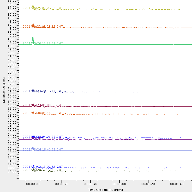
Events Processed for this Station
Download zip of receiver functions as SAC
Plot maxima for each earthquake.
Events Used in the Stack
(11 events)| Radial Match | Distance | Baz | FERegion | Time | Lat/Lon | Depth | Magnitude |
| 99.9425 | 46.7 deg | 193.253 deg | Central East Pacific Rise | 2001/06/26 12:33:52 GMT | (-4.1, -104.5) | 10 km | 5.0 MB, 5.8 MS, 6.0 MW, 6.0 MW |
| 99.851036 | 79.1 deg | 319.305 deg | Kuril Islands | 2002/08/24 18:40:53 GMT | (43.1, 146.1) | 43 km | 5.9 MB, 5.8 MS, 6.2 MW, 6.1 MW |
| 98.131744 | 61.2 deg | 156.658 deg | Near Coast Of Peru | 2001/06/23 20:33:14 GMT | (-16.3, -73.6) | 33 km | 6.7 MB, 8.2 MS, 8.4 MW, 7.8 ME |
| 95.078316 | 68.0 deg | 153.389 deg | Chile-Bolivia Border Region | 2002/03/28 04:56:22 GMT | (-21.7, -68.3) | 125 km | 6.1 MB, 6.5 MW, 6.5 MW |
| 93.8738 | 85.3 deg | 328.761 deg | E. Russia-N.E. China Border Reg. | 2002/06/28 17:19:30 GMT | (43.8, 130.7) | 566 km | 6.7 MB, 7.3 MW, 7.3 MW |
| 93.11401 | 65.6 deg | 153.418 deg | Northern Chile | 2001/07/24 05:00:09 GMT | (-19.4, -69.3) | 33 km | 5.7 MB, 6.2 MS, 6.3 MW, 6.3 MW |
| 90.94084 | 84.4 deg | 319.841 deg | Eastern Honshu, Japan | 2001/12/02 13:01:53 GMT | (39.4, 141.1) | 124 km | 6.1 MB, 6.5 MW, 6.5 MW |
| 87.57198 | 75.7 deg | 159.078 deg | Near Coast Of Central Chile | 2002/06/18 13:56:22 GMT | (-30.8, -71.1) | 54 km | 6.0 MB, 6.6 MW, 6.4 MW |
| 84.18727 | 75.2 deg | 154.775 deg | Catamarca Province, Argentina | 2002/05/28 04:04:22 GMT | (-28.9, -66.8) | 22 km | 6.0 MB, 5.7 MS, 6.0 MW, 5.9 MW |
| 82.045654 | 35.9 deg | 159.29 deg | South Of Panama | 2001/08/25 02:02:02 GMT | (7.6, -82.8) | 24 km | 5.9 MB, 5.7 MS, 6.2 MW, 6.1 MW |
| 80.928505 | 41.6 deg | 150.903 deg | Colombia | 2001/09/22 03:23:38 GMT | (3.9, -76.0) | 179 km | 6.0 MB, 6.0 MW, 6.0 MW |
Losers
(0 events)| Radial Match | Distance | Baz | FERegion | Time | Lat/Lon | Depth | Magnitude | Reason |
