
Station XW AHQI - XW.AHQI
Network: XW97 - Tien Shan Continental Dynamics
Nearby stations (2 deg radius)
| Station | Name | (Lat, Lon) | Start / End | Elevation |
| AHQI | XW.AHQI | (40.93, 78.46) | 1999-06-12 / 2002-01-01 | 1959 m |
| Crust2 Type: | PE,orogen/50km, Tibet, 0.5 km seds. |
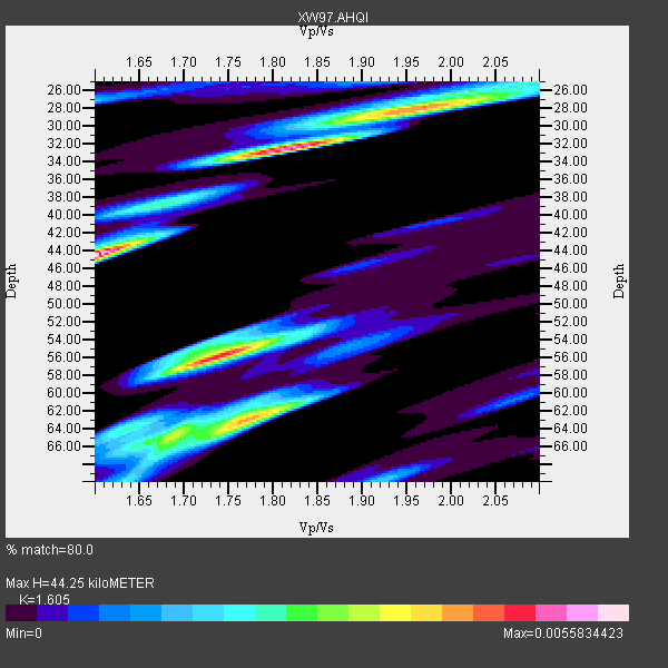
| Thickness Estimate: | 44 km |
| Thickness StdDev: | 15 km |
| Vp/Vs Estimate: | 1.61 |
| Vp/Vs StdDev: | 0.11 |
| Vs Estimate: | 3.958 km/s |
| Poisson's Ratio: | 0.18 |
| Peak Value: | 0.01 |
| Assumed Vp: | 6.353 km/s |
| Ps Weight: | 0.33333334 |
| PpPs Weight: | 0.33333334 |
| PsPs Weight: | 0.33333328 |
| Residual Complexity: | 0.911 |
| Nearby stations H: | +- |
| (2.0 deg) Vp/Vs: | +- |
2 with match > 90% ( 18.181818 %) and 10 with match > 80% ( 90.90909 %) out of 11.
Download stack as xyz text file.
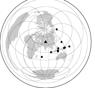
Azimuth Distribution of Events:
Prior Results for this Station
| Study | Thickness | Vp/Vs | Vp | Vs | Poissons Ratio | Extra |
| EARS | 44 km | 1.61 | 6.353 km/s | 3.958 km/s | 0.18 | |
| Crust2.0 | 50 km | 1.76 | 6.353 km/s | 3.612 km/s | 0.26 | PE,orogen/50km, Tibet, 0.5 km seds. |
| Global Maxima | 44 km | 1.61 | 6.353 km/s | 3.958 km/s | 0.18 | amp=0.0055834423 |
| Local Maxima 1 | 32 km | 1.82 | 6.353 km/s | 3.486 km/s | 0.28 | amp=0.004937585 |
| Local Maxima 2 | 56 km | 1.73 | 6.353 km/s | 3.667 km/s | 0.25 | amp=0.004703707 |
| Local Maxima 3 | 63 km | 1.77 | 6.353 km/s | 3.594 km/s | 0.26 | amp=0.003986721 |
| Local Maxima 4 | 28 km | 1.96 | 6.353 km/s | 3.245 km/s | 0.32 | amp=0.0029446175 |
| Predicted Arrivals for vertical incidence (zero ray parameter) | |
| Ps | 4.21 SECOND |
| PpPs | 18.14 SECOND |
| PsPs/PpSs | 22.36 SECOND |
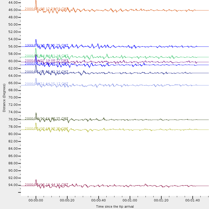
Events Processed for this Station
Download zip of receiver functions as SAC
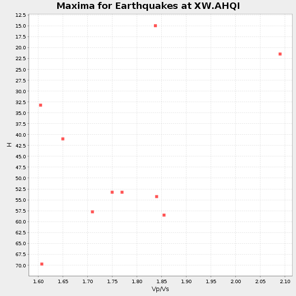
Plot maxima for each earthquake.
Events Used in the Stack
(10 events)| Radial Match | Distance | Baz | FERegion | Time | Lat/Lon | Depth | Magnitude |
| 92.607376 | 63.1 deg | 89.809 deg | Mariana Islands Region | 2000/05/02 15:03:36 GMT | (17.4, 147.5) | 55 km | 5.8 MB, 5.9 MW, 5.9 MW |
| 90.19685 | 95.0 deg | 100.482 deg | Santa Cruz Islands | 2000/05/06 13:44:13 GMT | (-11.3, 165.4) | 12 km | 6.0 MB, 6.3 MS, 6.3 MW, 5.8 ME |
| 89.336494 | 79.1 deg | 105.623 deg | New Britain Region, P.N.G. | 2000/05/08 10:28:25 GMT | (-4.5, 150.0) | 502 km | 5.7 MB, 6.1 MW, 6.1 MW |
| 89.17428 | 58.5 deg | 123.844 deg | Sulawesi, Indonesia | 2000/05/04 04:21:16 GMT | (-1.1, 123.6) | 26 km | 6.7 MB, 7.5 MS, 7.6 MW, 7.5 ME |
| 88.19661 | 76.3 deg | 107.689 deg | Bismarck Sea | 2000/04/30 21:08:35 GMT | (-4.0, 146.6) | 10 km | 5.3 MB, 5.7 MS, 5.9 MW, 5.9 MW |
| 87.81913 | 60.8 deg | 126.493 deg | Banda Sea | 2000/05/14 20:08:34 GMT | (-4.3, 123.2) | 33 km | 5.9 MB, 5.9 MS, 6.3 MW, 6.2 MW |
| 86.88064 | 66.5 deg | 41.623 deg | Andreanof Islands, Aleutian Is. | 2000/04/21 04:35:17 GMT | (51.4, -178.1) | 33 km | 6.0 MB, 5.7 MS, 6.2 ML, 6.0 MW |
| 86.64995 | 59.9 deg | 194.258 deg | Mauritius - Reunion Region | 2000/04/07 19:08:27 GMT | (-18.0, 65.5) | 10 km | 5.5 MB, 5.9 MS, 6.3 MW, 6.2 MW |
| 82.79996 | 45.2 deg | 151.895 deg | Southwest Of Sumatra, Indonesia | 2000/05/08 12:29:59 GMT | (-0.8, 98.0) | 33 km | 5.6 MB, 5.3 MS, 5.9 MW, 5.6 MW |
| 81.719765 | 55.6 deg | 115.942 deg | Mindanao, Philippines | 1999/06/18 10:55:25 GMT | (5.5, 126.6) | 33 km | 6.1 MB, 6.1 MS, 6.4 MW, 6.4 MW |
Losers
(1 events)| Radial Match | Distance | Baz | FERegion | Time | Lat/Lon | Depth | Magnitude | Reason |
| 74.42423 | 77.5 deg | 108.512 deg | Eastern New Guinea Reg., P.N.G. | 1999/06/19 09:03:09 GMT | (-5.4, 146.9) | 208 km | 5.7 MW, 5.1 MB, 5.6 MW |
