
Station XL S122 - Five Springs Road
Network: XL97 - Deep Probe (Archean-Proterozoic)
Nearby stations (2 deg radius)
| Station | Name | (Lat, Lon) | Start / End | Elevation |
| S122 | Five Springs Road | (40.60, -108.79) | 1997-05-07 / 1997-12-31 | 2093 m |
| Crust2 Type: | Q4,orogen/43km no ice, Tethian Belt, 5 km seds. |
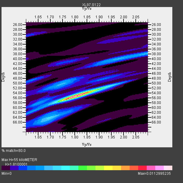
| Thickness Estimate: | 55 km |
| Thickness StdDev: | 3.5 km |
| Vp/Vs Estimate: | 1.81 |
| Vp/Vs StdDev: | 0.06 |
| Vs Estimate: | 3.429 km/s |
| Poisson's Ratio: | 0.28 |
| Peak Value: | 0.01 |
| Assumed Vp: | 6.207 km/s |
| Ps Weight: | 0.33333334 |
| PpPs Weight: | 0.33333334 |
| PsPs Weight: | 0.33333328 |
| Residual Complexity: | 0.540 |
| Nearby stations H: | +- |
| (2.0 deg) Vp/Vs: | +- |
7 with match > 90% ( 33.333332 %) and 12 with match > 80% ( 57.142857 %) out of 21.
Download stack as xyz text file.
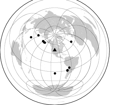
Azimuth Distribution of Events:
Prior Results for this Station
| Study | Thickness | Vp/Vs | Vp | Vs | Poissons Ratio | Extra |
| EARS | 55 km | 1.81 | 6.207 km/s | 3.429 km/s | 0.28 | |
| Crust2.0 | 43 km | 1.76 | 6.207 km/s | 3.535 km/s | 0.26 | Q4,orogen/43km no ice, Tethian Belt, 5 km seds. |
| Global Maxima | 55 km | 1.81 | 6.207 km/s | 3.429 km/s | 0.28 | amp=0.0112995235 |
| Local Maxima 1 | 52 km | 1.92 | 6.207 km/s | 3.224 km/s | 0.32 | amp=0.0037616342 |
| Local Maxima 2 | 50 km | 1.74 | 6.207 km/s | 3.562 km/s | 0.25 | amp=0.003142082 |
| Local Maxima 3 | 38 km | 2.09 | 6.207 km/s | 2.97 km/s | 0.35 | amp=0.0028619946 |
| Local Maxima 4 | 64 km | 1.66 | 6.207 km/s | 3.728 km/s | 0.22 | amp=0.0020198063 |
| Predicted Arrivals for vertical incidence (zero ray parameter) | |
| Ps | 7.18 SECOND |
| PpPs | 24.90 SECOND |
| PsPs/PpSs | 32.08 SECOND |
Events Processed for this Station
Download zip of receiver functions as SAC
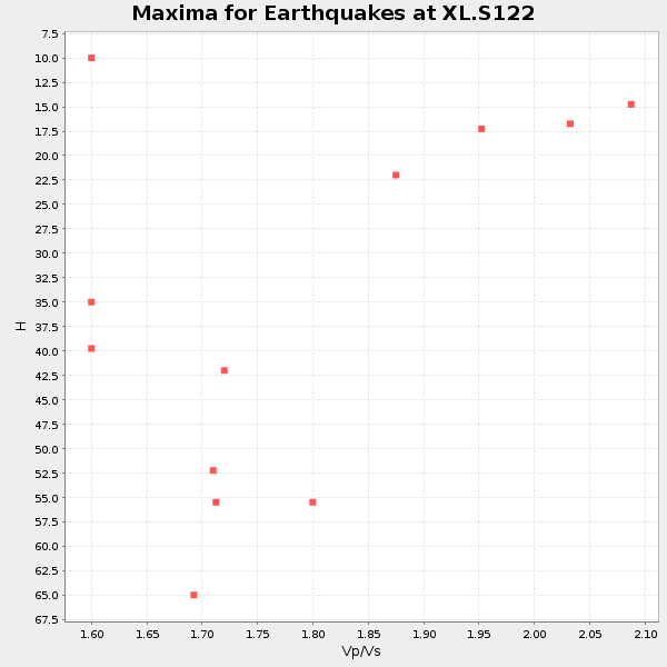
Plot maxima for each earthquake.
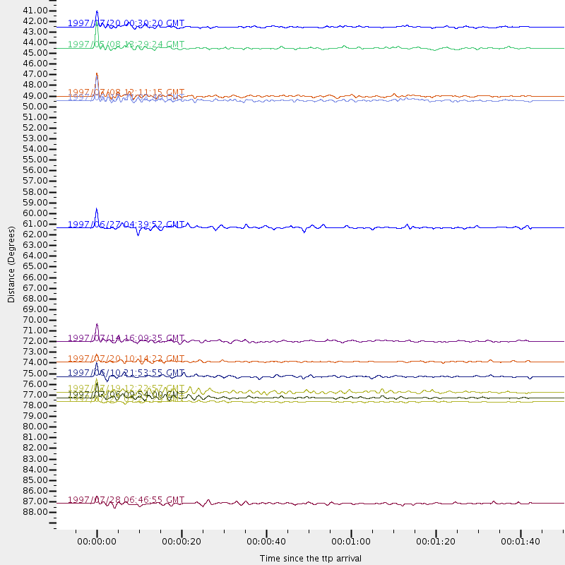
Events Used in the Stack
(12 events)| Radial Match | Distance | Baz | FERegion | Time | Lat/Lon | Depth | Magnitude |
| 96.203964 | 48.4 deg | 307.738 deg | Andreanof Islands, Aleutian Is. | 1997/06/17 21:03:40 GMT | (51.3, -179.3) | 33 km | 6.4 MB, 6.3 MS, 6.4 UNKNOWN, 6.6 ML |
| 94.231964 | 41.0 deg | 307.308 deg | Fox Islands, Aleutian Islands | 1997/07/20 00:30:20 GMT | (52.6, -167.5) | 14 km | 5.6 MB, 5.9 MS, 6.2 UNKNOWN, 6.2 MW |
| 93.867294 | 78.2 deg | 147.857 deg | Near Coast Of Central Chile | 1997/07/06 09:54:00 GMT | (-30.1, -71.9) | 19 km | 5.8 MB, 6.5 MS, 6.8 UNKNOWN, 6.4 ME |
| 93.47161 | 43.1 deg | 306.527 deg | Fox Islands, Aleutian Islands | 1997/05/08 13:29:24 GMT | (51.7, -170.8) | 33 km | 5.8 MB, 5.9 MS, 6.0 UNKNOWN, 6.0 MW |
| 92.803154 | 47.9 deg | 307.596 deg | Andreanof Islands, Aleutian Is. | 1997/07/08 12:11:15 GMT | (51.4, -178.6) | 33 km | 5.5 MB, 5.4 MS, 5.8 UNKNOWN, 5.6 ML |
| 92.13113 | 76.0 deg | 179.452 deg | Southern East Pacific Rise | 1997/06/10 21:53:55 GMT | (-35.8, -108.1) | 10 km | 5.8 MB, 6.1 MS, 6.5 UNKNOWN, 5.8 MS |
| 90.42125 | 72.5 deg | 312.227 deg | Kuril Islands | 1997/07/14 16:09:35 GMT | (43.2, 146.4) | 33 km | 5.9 MB, 5.8 MS, 6.1 UNKNOWN, 5.8 ME |
| 88.744354 | 61.1 deg | 62.802 deg | Azores Islands, Portugal | 1997/06/27 04:39:52 GMT | (38.3, -26.7) | 10 km | 5.6 MB, 5.4 MS, 5.9 UNKNOWN, 5.9 MW |
| 88.35369 | 74.6 deg | 139.782 deg | Jujuy Province, Argentina | 1997/07/20 10:14:22 GMT | (-23.0, -66.3) | 256 km | 5.7 MB, 6.1 UNKNOWN, 5.7 ME |
| 85.73783 | 77.6 deg | 147.338 deg | Near Coast Of Central Chile | 1997/07/19 12:22:57 GMT | (-29.3, -71.7) | 26 km | 5.8 MB, 5.5 MS, 5.9 UNKNOWN, 5.8 MW |
| 83.85051 | 88.8 deg | 298.573 deg | Volcano Islands, Japan Region | 1997/07/28 06:46:55 GMT | (22.4, 142.7) | 33 km | 5.7 MB, 5.8 MS, 5.9 UNKNOWN, 5.9 MW |
| 83.27391 | 78.6 deg | 148.067 deg | Near Coast Of Central Chile | 1997/07/27 05:21:29 GMT | (-30.5, -71.9) | 33 km | 5.6 MB, 5.8 MS, 6.3 UNKNOWN, 6.2 MW |
Losers
(9 events)| Radial Match | Distance | Baz | FERegion | Time | Lat/Lon | Depth | Magnitude | Reason |
| 83.99273 | 34.0 deg | 139.992 deg | Near Coast Of Nicaragua | 1997/05/08 14:01:10 GMT | (12.3, -87.2) | 59 km | 5.6 UNKNOWN, 5.3 MB | |
| 76.61382 | 78.5 deg | 148.076 deg | Near Coast Of Central Chile | 1997/07/25 06:47:02 GMT | (-30.5, -71.9) | 33 km | 5.6 MB, 5.5 MS, 6.3 UNKNOWN | |
| 68.22837 | 87.8 deg | 299.634 deg | Volcano Islands, Japan Region | 1997/07/08 02:24:07 GMT | (23.8, 142.7) | 33 km | 5.8 MB, 5.6 MS, 5.9 UNKNOWN, 5.8 MW | |
| 63.5835 | 44.8 deg | 175.626 deg | Central East Pacific Rise | 1997/08/15 07:37:49 GMT | (-4.4, -105.7) | 10 km | 5.3 MB, 5.8 MS, 6.2 UNKNOWN, 6.1 MW | |
| 52.146687 | 86.9 deg | 313.947 deg | Western Honshu, Japan | 1997/06/25 09:50:12 GMT | (34.4, 131.6) | 10 km | 5.5 MB, 5.6 MS, 5.9 UNKNOWN, 5.8 MW | |
| 45.412724 | 90.5 deg | 238.477 deg | South Of Fiji Islands | 1997/06/11 09:29:23 GMT | (-24.0, -177.5) | 164 km | 5.9 UNKNOWN, 5.4 MB, 5.5 MB | |
| 45.019173 | 97.3 deg | 311.824 deg | Southwestern Ryukyu Isl., Japan | 1997/08/13 04:45:04 GMT | (25.0, 125.8) | 55 km | 6.0 MB, 5.6 MS, 6.1 UNKNOWN, 6.1 MW | |
| 36.1577 | 87.1 deg | 243.715 deg | Fiji Islands Region | 1997/06/11 11:53:32 GMT | (-17.8, -178.8) | 573 km | 5.5 UNKNOWN, 4.9 MB | |
| 10.617088 | 85.7 deg | 245.59 deg | Fiji Islands Region | 1997/08/08 22:27:19 GMT | (-15.5, -179.1) | 10 km | 5.7 MB, 6.6 MS, 6.6 UNKNOWN, 6.4 MW |
