
Station XM NM42 - NewMexico42
Network: XM99 - Rio Grande Seismic Transect
Nearby stations (2 deg radius)
| Station | Name | (Lat, Lon) | Start / End | Elevation |
| NM42 | NewMexico42 | (36.15, -108.72) | 1999-07-28 / 2001-12-31 | 1794 m |
| Crust2 Type: | Q6,orogen/41.5km no ice, cordilleras, 1.5 km seds. |
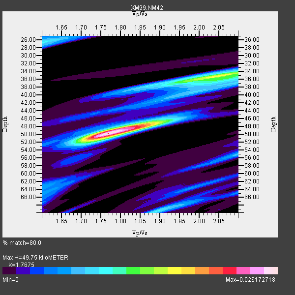
| Thickness Estimate: | 50 km |
| Thickness StdDev: | 6.8 km |
| Vp/Vs Estimate: | 1.77 |
| Vp/Vs StdDev: | 0.11 |
| Vs Estimate: | 3.664 km/s |
| Poisson's Ratio: | 0.26 |
| Peak Value: | 0.03 |
| Assumed Vp: | 6.476 km/s |
| Ps Weight: | 0.33333334 |
| PpPs Weight: | 0.33333334 |
| PsPs Weight: | 0.33333328 |
| Residual Complexity: | 0.643 |
| Nearby stations H: | +- |
| (2.0 deg) Vp/Vs: | +- |
7 with match > 90% ( 43.75 %) and 15 with match > 80% ( 93.75 %) out of 16.
Download stack as xyz text file.
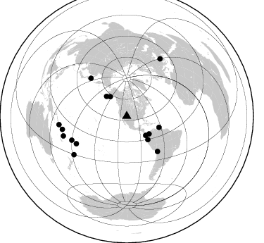
Azimuth Distribution of Events:
Prior Results for this Station
| Study | Thickness | Vp/Vs | Vp | Vs | Poissons Ratio | Extra |
| EARS | 50 km | 1.77 | 6.476 km/s | 3.664 km/s | 0.26 | |
| Crust2.0 | 42 km | 1.76 | 6.476 km/s | 3.675 km/s | 0.26 | Q6,orogen/41.5km no ice, cordilleras, 1.5 km seds. |
| Wilson | 47 km | 1.75 | 6.25 km/s | 3.571 km/s | 0.26 | |
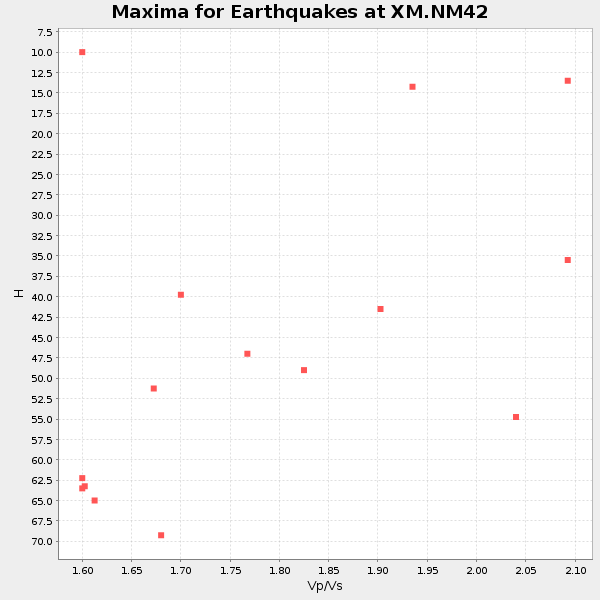
| Global Maxima | 50 km | 1.77 | 6.476 km/s | 3.664 km/s | 0.26 | amp=0.026172718 |
| Local Maxima 1 | 35 km | 2.04 | 6.476 km/s | 3.171 km/s | 0.34 | amp=0.015889991 |
| Local Maxima 2 | 47 km | 1.88 | 6.476 km/s | 3.435 km/s | 0.30 | amp=0.010493832 |
| Local Maxima 3 | 26 km | 1.60 | 6.476 km/s | 4.047 km/s | 0.18 | amp=0.009513786 |
| Local Maxima 4 | 70 km | 1.89 | 6.476 km/s | 3.426 km/s | 0.31 | amp=0.009253604 |
| Predicted Arrivals for vertical incidence (zero ray parameter) | |
| Ps | 5.90 SECOND |
| PpPs | 21.26 SECOND |
| PsPs/PpSs | 27.16 SECOND |
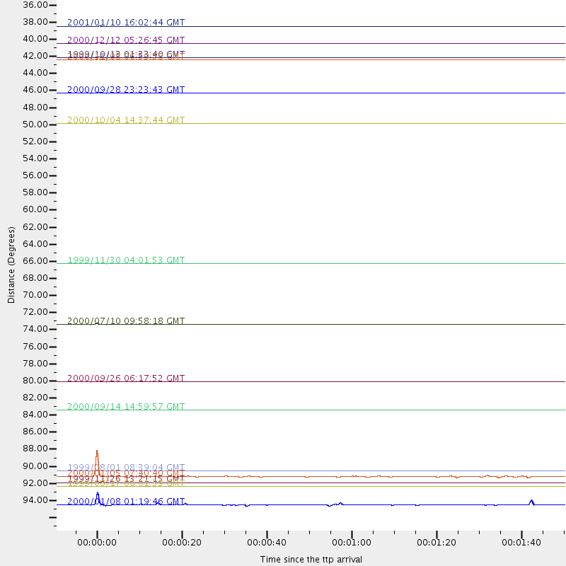
Events Processed for this Station
Download zip of receiver functions as SAC
Plot maxima for each earthquake.
Events Used in the Stack
(15 events)| Radial Match | Distance | Baz | FERegion | Time | Lat/Lon | Depth | Magnitude |
| 99.99944 | 74.0 deg | 316.607 deg | Sea Of Okhotsk | 2000/07/10 09:58:18 GMT | (46.8, 145.4) | 360 km | 6.1 MB, 5.9 MW, 5.8 MW |
| 97.573166 | 94.1 deg | 252.771 deg | Vanuatu Islands | 1999/11/26 13:21:15 GMT | (-16.4, 168.2) | 33 km | 6.4 MB, 7.3 MS, 7.5 MW, 7.3 MW |
| 97.32823 | 93.3 deg | 258.462 deg | Santa Cruz Islands | 2000/01/05 07:40:40 GMT | (-11.4, 165.4) | 33 km | 5.7 MB, 6.0 MS, 6.2 MW, 6.1 MW |
| 95.73519 | 48.5 deg | 109.027 deg | Windward Islands | 2000/10/04 14:37:44 GMT | (11.1, -62.6) | 110 km | 5.6 MB, 5.4 MS, 6.1 MW, 5.9 MD |
| 94.68706 | 81.3 deg | 241.41 deg | Tonga Islands | 2000/09/26 06:17:52 GMT | (-17.2, -173.9) | 56 km | 6.1 MB, 6.1 MS, 6.4 MW, 6.1 ME |
| 92.75856 | 40.5 deg | 128.249 deg | Panama-Colombia Border Region | 2000/11/08 06:59:58 GMT | (7.0, -77.8) | 17 km | 6.0 MB, 6.4 MS, 6.5 MW, 6.2 ML |
| 90.699585 | 44.6 deg | 137.847 deg | Near Coast Of Ecuador | 2000/09/28 23:23:43 GMT | (-0.2, -80.6) | 23 km | 5.8 MB, 6.0 MS, 6.6 MW, 6.4 MW |
| 86.942924 | 36.2 deg | 319.575 deg | Kodiak Island Region, Alaska | 2001/01/10 16:02:44 GMT | (57.1, -153.2) | 33 km | 6.2 MB, 6.8 MS, 7.1 MW, 6.8 ML |
| 86.9414 | 38.3 deg | 135.26 deg | South Of Panama | 2000/12/12 05:26:45 GMT | (6.0, -82.7) | 10 km | 5.8 MB, 5.7 MS, 6.3 ME, 6.1 MW |
| 85.58868 | 92.6 deg | 233.935 deg | Kermadec Islands, New Zealand | 1999/08/01 08:39:04 GMT | (-30.4, -177.8) | 10 km | 5.7 MB, 6.4 MS, 6.6 MW, 6.0 ME |
| 85.30251 | 94.5 deg | 30.279 deg | Turkey | 1999/08/17 00:01:39 GMT | (40.7, 29.9) | 17 km | 6.3 MB, 7.8 MS, 7.7 ME, 7.6 MW |
| 82.75336 | 96.9 deg | 262.937 deg | Solomon Islands | 2000/01/08 01:19:46 GMT | (-9.8, 159.8) | 33 km | 5.8 MB, 6.4 MS, 6.3 MW, 6.3 MW |
| 82.679695 | 84.9 deg | 246.457 deg | Fiji Islands | 2000/09/14 14:59:57 GMT | (-15.7, 179.8) | 33 km | 5.7 MB, 6.2 MS, 6.3 MW, 6.2 MW |
| 80.69296 | 40.1 deg | 314.374 deg | Alaska Peninsula | 1999/10/13 01:33:40 GMT | (54.7, -161.2) | 30 km | 6.0 MB, 6.2 MS, 6.5 MW, 6.0 ML |
| 80.048645 | 66.3 deg | 138.833 deg | Northern Chile | 1999/11/30 04:01:53 GMT | (-18.9, -69.2) | 128 km | 6.2 MB, 6.6 MW, 6.5 MW |
Losers
(1 events)| Radial Match | Distance | Baz | FERegion | Time | Lat/Lon | Depth | Magnitude | Reason |
| 96.38603 | 95.9 deg | 247.221 deg | Southeast Of Loyalty Islands | 2001/02/28 13:05:31 GMT | (-22.0, 170.1) | 10 km | 5.8 MB, 6.1 MS, 6.2 MW |
