
Station XW HLQI - XW.HLQI
Network: XW97 - Tien Shan Continental Dynamics
Nearby stations (2 deg radius)
| Station | Name | (Lat, Lon) | Start / End | Elevation |
| HLQI | XW.HLQI | (40.84, 77.96) | 1999-06-12 / 2002-01-01 | 2241 m |
| Crust2 Type: | R4,orogen/55km Tibet Transition, 0 km seds. |
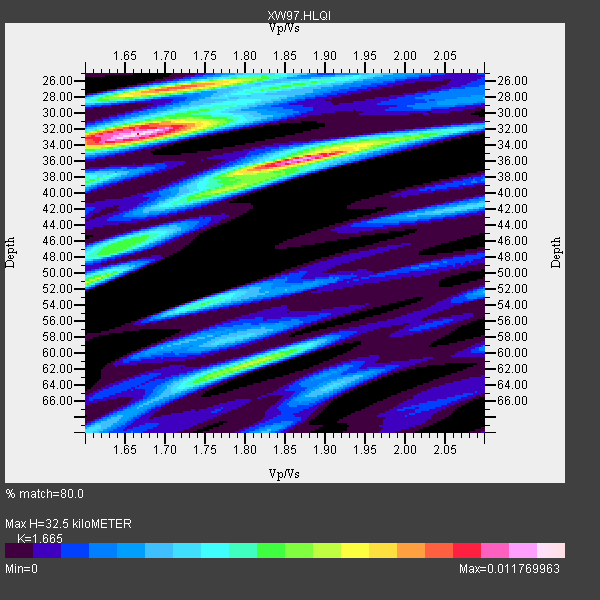
| Thickness Estimate: | 32 km |
| Thickness StdDev: | 8.3 km |
| Vp/Vs Estimate: | 1.66 |
| Vp/Vs StdDev: | 0.11 |
| Vs Estimate: | 3.898 km/s |
| Poisson's Ratio: | 0.22 |
| Peak Value: | 0.01 |
| Assumed Vp: | 6.491 km/s |
| Ps Weight: | 0.33333334 |
| PpPs Weight: | 0.33333334 |
| PsPs Weight: | 0.33333328 |
| Residual Complexity: | 0.832 |
| Nearby stations H: | +- |
| (2.0 deg) Vp/Vs: | +- |
10 with match > 90% ( 62.5 %) and 15 with match > 80% ( 93.75 %) out of 16.
Download stack as xyz text file.
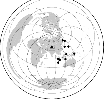
Azimuth Distribution of Events:
Prior Results for this Station
| Study | Thickness | Vp/Vs | Vp | Vs | Poissons Ratio | Extra |
| EARS | 32 km | 1.66 | 6.491 km/s | 3.898 km/s | 0.22 | |
| Crust2.0 | 55 km | 1.76 | 6.491 km/s | 3.696 km/s | 0.26 | R4,orogen/55km Tibet Transition, 0 km seds. |
| Global Maxima | 32 km | 1.66 | 6.491 km/s | 3.898 km/s | 0.22 | amp=0.011769963 |
| Local Maxima 1 | 36 km | 1.88 | 6.491 km/s | 3.462 km/s | 0.30 | amp=0.010845029 |
| Local Maxima 2 | 27 km | 1.71 | 6.491 km/s | 3.796 km/s | 0.24 | amp=0.009086976 |
| Local Maxima 3 | 51 km | 1.60 | 6.491 km/s | 4.057 km/s | 0.18 | amp=0.006944831 |
| Local Maxima 4 | 61 km | 1.80 | 6.491 km/s | 3.601 km/s | 0.28 | amp=0.00688727 |
| Predicted Arrivals for vertical incidence (zero ray parameter) | |
| Ps | 3.33 SECOND |
| PpPs | 13.34 SECOND |
| PsPs/PpSs | 16.67 SECOND |
Events Processed for this Station
Download zip of receiver functions as SAC
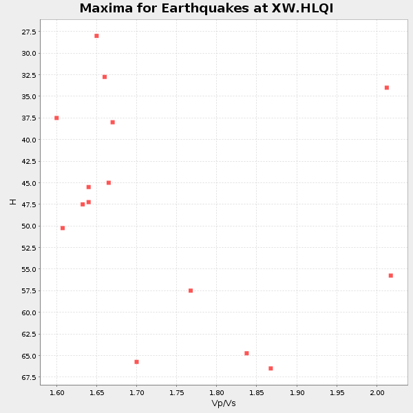
Plot maxima for each earthquake.
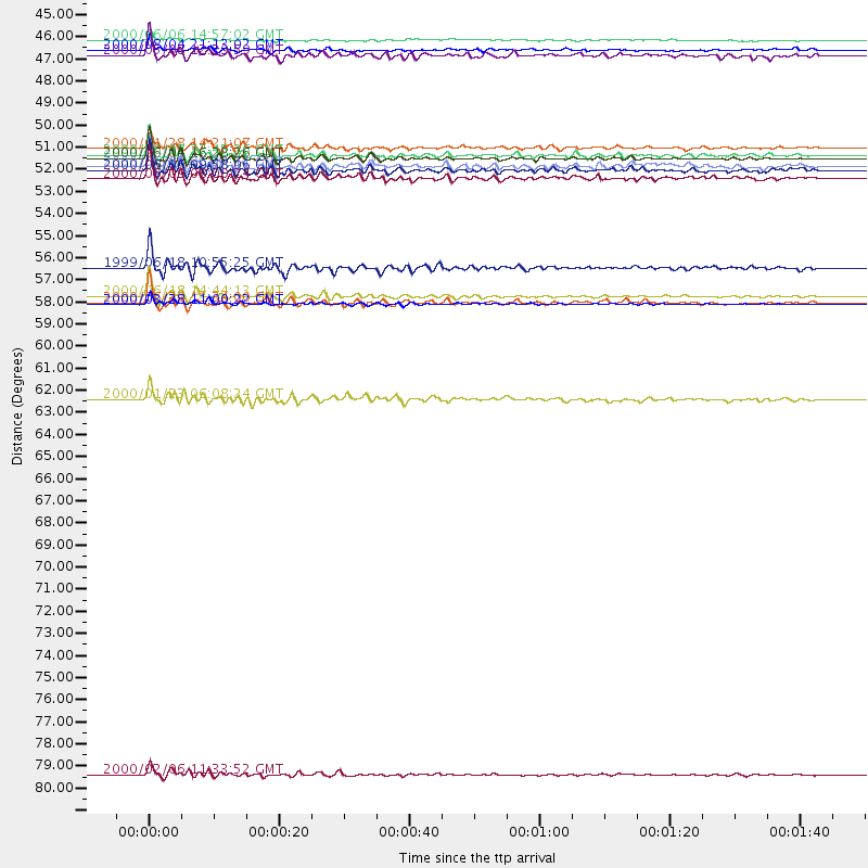
Events Used in the Stack
(15 events)| Radial Match | Distance | Baz | FERegion | Time | Lat/Lon | Depth | Magnitude |
| 97.42344 | 50.4 deg | 148.108 deg | Southern Sumatra, Indonesia | 2000/06/04 16:28:26 GMT | (-4.7, 102.1) | 33 km | 6.8 MB, 8.0 MS, 7.9 MW, 7.7 MW |
| 96.961 | 57.3 deg | 157.344 deg | South Indian Ocean | 2000/06/18 14:44:13 GMT | (-13.8, 97.5) | 10 km | 6.8 MB, 7.8 MS, 7.8 MW, 7.6 MW |
| 95.86903 | 50.3 deg | 148.267 deg | Southern Sumatra, Indonesia | 2000/06/07 23:45:26 GMT | (-4.6, 101.9) | 33 km | 6.1 MB, 6.7 MS, 6.7 MW, 6.5 MW |
| 94.84405 | 57.7 deg | 87.347 deg | Volcano Islands, Japan Region | 2000/03/28 11:00:22 GMT | (22.3, 143.7) | 126 km | 6.8 MB, 7.6 MS, 7.6 MW, 7.6 MW |
| 94.384186 | 51.4 deg | 147.841 deg | Southern Sumatra, Indonesia | 2000/06/09 08:00:24 GMT | (-5.5, 102.7) | 33 km | 5.8 MB, 5.8 MS, 6.0 MW, 6.0 MW |
| 92.86332 | 55.9 deg | 115.452 deg | Mindanao, Philippines | 1999/06/18 10:55:25 GMT | (5.5, 126.6) | 33 km | 6.1 MB, 6.1 MS, 6.4 MW, 6.4 MW |
| 92.77824 | 51.0 deg | 147.582 deg | Southern Sumatra, Indonesia | 2000/06/06 09:58:06 GMT | (-5.1, 102.7) | 33 km | 5.8 MB, 6.1 MS, 6.2 MW, 6.1 MW |
| 91.81329 | 57.6 deg | 157.315 deg | South Indian Ocean | 2000/06/20 11:34:00 GMT | (-14.1, 97.6) | 10 km | 5.6 MB, 5.6 MS, 6.1 MW, 5.8 MW |
| 90.60027 | 50.8 deg | 147.536 deg | Southern Sumatra, Indonesia | 2000/06/05 06:34:11 GMT | (-4.9, 102.7) | 33 km | 5.4 MB, 5.5 MS, 5.8 MW |
| 90.50423 | 81.0 deg | 105.693 deg | New Britain Region, P.N.G. | 2000/02/06 11:33:52 GMT | (-5.8, 150.9) | 33 km | 6.6 MB, 6.8 MS, 6.6 MW, 6.3 ME |
| 89.402176 | 45.1 deg | 57.33 deg | Sakhalin, Russia | 2000/08/04 21:13:02 GMT | (48.8, 142.2) | 10 km | 6.3 MB, 7.1 MS, 6.8 MW, 6.7 MW |
| 88.82088 | 49.9 deg | 63.303 deg | Kuril Islands | 2000/01/28 14:21:07 GMT | (43.0, 146.8) | 61 km | 6.7 MB, 6.6 MS, 6.8 MW, 6.8 ME |
| 86.32923 | 45.3 deg | 151.204 deg | Southwest Of Sumatra, Indonesia | 2000/05/08 12:29:59 GMT | (-0.8, 98.0) | 33 km | 5.6 MB, 5.3 MS, 5.9 MW, 5.6 MW |
| 86.27934 | 62.4 deg | 130.791 deg | Flores Sea | 2000/01/23 06:08:24 GMT | (-8.0, 120.6) | 47 km | 5.7 MB, 5.2 MS, 5.8 MW, 5.7 MW |
| 81.033966 | 44.6 deg | 87.352 deg | Southeast Of Ryukyu Islands | 2000/06/06 14:57:02 GMT | (29.4, 131.4) | 33 km | 5.8 MB, 6.0 MS, 6.4 MW, 6.4 MW |
Losers
(1 events)| Radial Match | Distance | Baz | FERegion | Time | Lat/Lon | Depth | Magnitude | Reason |
| 78.84649 | 77.8 deg | 108.146 deg | Eastern New Guinea Reg., P.N.G. | 1999/06/19 09:03:09 GMT | (-5.4, 146.9) | 208 km | 5.7 MW, 5.1 MB, 5.6 MW |
