
Station YF DUOK - YF.DUOK
Network: YF99 - Midsea - Mantle Investigation of the Deep Suture between Eurasia and Africa
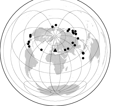
Nearby stations (2 deg radius)
| Station | Name | (Lat, Lon) | Start / End | Elevation |
| DUOK | YF.DUOK | (44.11, 14.93) | 1999-07-16 / 2001-12-31 | 0.1 km |
| Crust2 Type: | M9,thick extended crust, 0.5 km seds. |
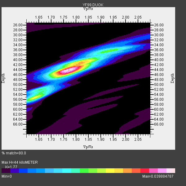
| Thickness Estimate: | 44 km |
| Thickness StdDev: | 2.8 km |
| Vp/Vs Estimate: | 1.77 |
| Vp/Vs StdDev: | 0.04 |
| Vs Estimate: | 3.554 km/s |
| Poisson's Ratio: | 0.27 |
| Peak Value: | 0.04 |
| Assumed Vp: | 6.291 km/s |
| Ps Weight: | 0.33333334 |
| PpPs Weight: | 0.33333334 |
| PsPs Weight: | 0.33333328 |
| Residual Complexity: | 0.555 |
| Nearby stations H: | +- |
| (2.0 deg) Vp/Vs: | +- |
17 with match > 90% ( 62.962963 %) and 27 with match > 80% ( 100.0 %) out of 27.
Download stack as xyz text file.
Azimuth Distribution of Events:
Prior Results for this Station
| Study | Thickness | Vp/Vs | Vp | Vs | Poissons Ratio | Extra |
| EARS | 44 km | 1.77 | 6.291 km/s | 3.554 km/s | 0.27 | |
| Crust2.0 | 40 km | 1.78 | 6.291 km/s | 3.539 km/s | 0.27 | M9,thick extended crust, 0.5 km seds. |
| Global Maxima | 44 km | 1.77 | 6.291 km/s | 3.554 km/s | 0.27 | amp=0.039884787 |
| Local Maxima 1 | 55 km | 1.64 | 6.291 km/s | 3.842 km/s | 0.20 | amp=0.023717318 |
| Local Maxima 2 | 41 km | 1.83 | 6.291 km/s | 3.433 km/s | 0.29 | amp=0.021287328 |
| Local Maxima 3 | 46 km | 1.76 | 6.291 km/s | 3.58 km/s | 0.26 | amp=0.015072029 |
| Local Maxima 4 | 36 km | 1.98 | 6.291 km/s | 3.177 km/s | 0.33 | amp=0.009453642 |
| Predicted Arrivals for vertical incidence (zero ray parameter) | |
| Ps | 5.39 SECOND |
| PpPs | 19.37 SECOND |
| PsPs/PpSs | 24.76 SECOND |
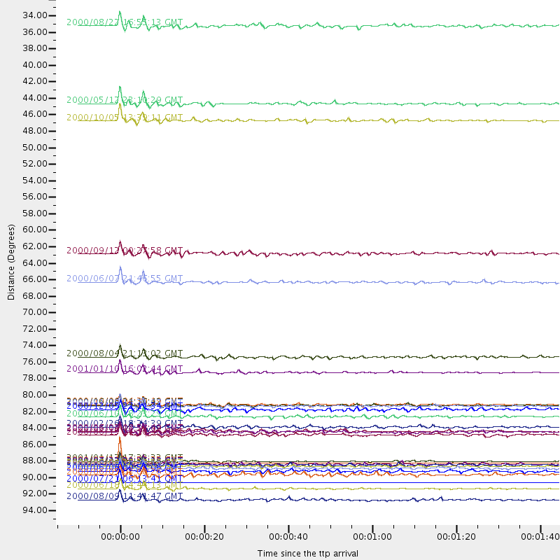
Events Processed for this Station
Download zip of receiver functions as SAC
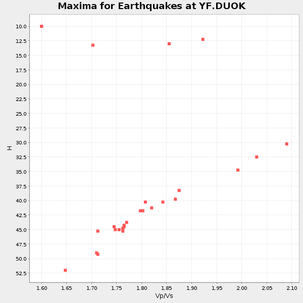
Plot maxima for each earthquake.
Events Used in the Stack
(27 events)| Radial Match | Distance | Baz | FERegion | Time | Lat/Lon | Depth | Magnitude |
| 100.0 | 90.8 deg | 283.828 deg | Off Coast Of Costa Rica | 2000/07/21 01:53:35 GMT | (9.4, -85.3) | 33 km | 5.9 MB, 6.1 MS, 6.4 MW, 5.7 ML |
| 100.0 | 93.4 deg | 299.556 deg | Central Mexico | 2000/07/21 06:13:41 GMT | (18.4, -98.9) | 80 km | 5.4 MB, 5.1 MS, 5.9 MW, 4.8 MD |
| 97.987 | 90.5 deg | 288.691 deg | El Salvador | 2001/01/13 17:33:32 GMT | (13.0, -88.7) | 60 km | 6.4 MB, 7.8 MS, 7.7 MW, 7.5 ME |
| 97.87305 | 83.2 deg | 33.334 deg | Kuril Islands | 2000/01/28 14:21:07 GMT | (43.0, 146.8) | 61 km | 6.7 MB, 6.6 MS, 6.8 MW, 6.8 ME |
| 97.56138 | 78.7 deg | 353.429 deg | Kodiak Island Region, Alaska | 2001/01/10 16:02:44 GMT | (57.1, -153.2) | 33 km | 6.2 MB, 6.8 MS, 7.1 MW, 6.8 ML |
| 97.5451 | 84.6 deg | 61.979 deg | Taiwan | 2000/06/10 18:23:29 GMT | (23.8, 121.2) | 33 km | 6.2 MB, 6.2 MS, 6.4 MW, 6.3 MW |
| 97.20261 | 91.2 deg | 95.349 deg | Southern Sumatra, Indonesia | 2000/06/04 16:28:26 GMT | (-4.7, 102.1) | 33 km | 6.8 MB, 8.0 MS, 7.9 MW, 7.7 MW |
| 97.17401 | 66.6 deg | 74.79 deg | Myanmar | 2000/06/07 21:46:55 GMT | (26.9, 97.2) | 33 km | 6.3 MB, 6.5 MS, 6.4 MW, 6.4 MW |
| 96.32436 | 94.2 deg | 105.021 deg | South Indian Ocean | 2000/06/18 14:44:13 GMT | (-13.8, 97.5) | 10 km | 6.8 MB, 7.8 MS, 7.8 MW, 7.6 MW |
| 96.04621 | 42.7 deg | 81.147 deg | Hindu Kush Region, Afghanistan | 2000/05/12 23:10:29 GMT | (36.0, 70.7) | 108 km | 6.2 MB, 6.3 MW, 6.3 MW |
| 94.82878 | 91.5 deg | 46.227 deg | Bonin Islands, Japan Region | 2000/08/06 07:27:12 GMT | (28.9, 139.6) | 395 km | 6.3 MB, 7.3 MW, 7.3 MW |
| 94.74001 | 86.6 deg | 51.46 deg | Southeast Of Ryukyu Islands | 2000/06/06 14:57:02 GMT | (29.4, 131.4) | 33 km | 5.8 MB, 6.0 MS, 6.4 MW, 6.4 MW |
| 94.53573 | 91.0 deg | 95.397 deg | Southern Sumatra, Indonesia | 2000/06/07 23:45:26 GMT | (-4.6, 101.9) | 33 km | 6.1 MB, 6.7 MS, 6.7 MW, 6.5 MW |
| 94.46132 | 45.0 deg | 273.693 deg | Northern Mid-Atlantic Ridge | 2000/10/05 13:39:11 GMT | (31.7, -41.0) | 10 km | 5.4 MB, 6.1 MS, 6.0 MW, 5.9 MW |
| 93.21125 | 83.1 deg | 44.12 deg | Sea Of Japan | 2000/06/06 21:16:42 GMT | (36.8, 135.5) | 10 km | 5.7 MB, 5.3 MS, 5.9 MW, 5.8 MW |
| 90.97943 | 86.5 deg | 41.666 deg | Near East Coast Of Honshu, Japan | 2000/06/03 08:54:49 GMT | (35.6, 140.5) | 62 km | 5.6 MB, 5.6 MS, 6.1 MW, 6.1 MW |
| 90.7106 | 86.0 deg | 279.131 deg | Panama | 2000/02/26 18:24:39 GMT | (9.4, -78.5) | 65 km | 5.8 MB, 5.4 MS, 6.2 MW, 6.1 MW |
| 89.55853 | 91.9 deg | 95.192 deg | Southern Sumatra, Indonesia | 2000/06/06 09:58:06 GMT | (-5.1, 102.7) | 33 km | 5.8 MB, 6.1 MS, 6.2 MW, 6.1 MW |
| 89.4483 | 95.7 deg | 301.993 deg | Michoacan, Mexico | 2000/08/09 11:41:47 GMT | (18.2, -102.5) | 46 km | 6.1 MB, 6.5 MS, 6.5 MW, 6.4 MW |
| 88.26546 | 83.0 deg | 46.465 deg | Western Honshu, Japan | 2000/10/06 04:30:19 GMT | (35.5, 133.1) | 10 km | 5.8 MB, 6.8 MS, 7.0 ME, 6.7 MW |
| 88.1317 | 91.0 deg | 94.688 deg | Southern Sumatra, Indonesia | 2000/07/22 20:56:12 GMT | (-4.1, 102.4) | 69 km | 5.8 MB, 5.8 MW, 5.7 MW |
| 86.43278 | 87.0 deg | 51.054 deg | Southeast Of Shikoku, Japan | 2000/06/15 11:10:46 GMT | (29.4, 132.1) | 10 km | 6.0 MB, 5.6 MS, 6.1 MW, 6.1 MW |
| 84.8235 | 76.6 deg | 32.731 deg | Sakhalin, Russia | 2000/08/04 21:13:02 GMT | (48.8, 142.2) | 10 km | 6.3 MB, 7.1 MS, 6.8 MW, 6.7 MW |
| 84.80173 | 92.4 deg | 95.429 deg | Southern Sumatra, Indonesia | 2000/06/05 03:00:26 GMT | (-5.6, 102.9) | 33 km | 5.5 MB, 5.5 MS, 5.8 MW, 5.8 MW |
| 84.72791 | 62.8 deg | 66.116 deg | Qinghai, China | 2000/09/12 00:27:58 GMT | (35.4, 99.3) | 10 km | 5.7 MB, 6.3 MS, 6.1 MW, 6.1 MW |
| 82.84355 | 32.3 deg | 85.808 deg | Turkmenistan-Iran Border Region | 2000/08/22 16:55:13 GMT | (38.1, 57.4) | 10 km | 5.2 MB, 5.8 MS, 5.8 MW, 5.7 MW |
| 80.68181 | 83.7 deg | 1.706 deg | Fox Islands, Aleutian Islands | 2000/12/05 22:11:34 GMT | (52.6, -167.8) | 33 km | 5.6 MB, 5.6 MS, 5.9 MW, 5.4 ML |
Losers
(0 events)| Radial Match | Distance | Baz | FERegion | Time | Lat/Lon | Depth | Magnitude | Reason |
