
Station YL GAIG - YL.GAIG
Network: YL01 - Himalayan Nepal Tibet Experiment
Nearby stations (2 deg radius)
| Station | Name | (Lat, Lon) | Start / End | Elevation |
| GAIG | YL.GAIG | (26.84, 86.63) | 2001-09-07 / 2003-01-01 | 166 m |
| Crust2 Type: | P7,orogen/50km, Urals, Tethian Orogen, 3 km seds. |
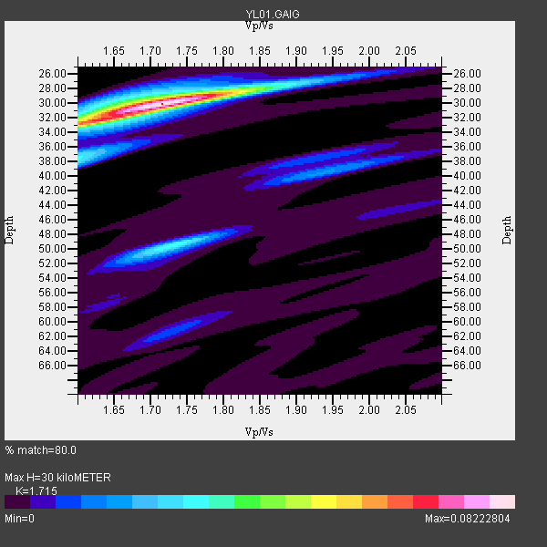
| Thickness Estimate: | 30 km |
| Thickness StdDev: | 1.0 km |
| Vp/Vs Estimate: | 1.72 |
| Vp/Vs StdDev: | 0.04 |
| Vs Estimate: | 3.636 km/s |
| Poisson's Ratio: | 0.24 |
| Peak Value: | 0.08 |
| Assumed Vp: | 6.236 km/s |
| Ps Weight: | 0.33333334 |
| PpPs Weight: | 0.33333334 |
| PsPs Weight: | 0.33333328 |
| Residual Complexity: | 0.400 |
| Nearby stations H: | +- |
| (2.0 deg) Vp/Vs: | +- |
3 with match > 90% ( 37.5 %) and 7 with match > 80% ( 87.5 %) out of 8.
Download stack as xyz text file.
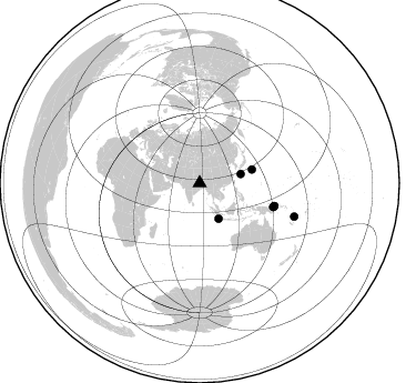
Azimuth Distribution of Events:
Prior Results for this Station
| Study | Thickness | Vp/Vs | Vp | Vs | Poissons Ratio | Extra |
| EARS | 30 km | 1.72 | 6.236 km/s | 3.636 km/s | 0.24 | |
| Crust2.0 | 53 km | 1.76 | 6.236 km/s | 3.536 km/s | 0.26 | P7,orogen/50km, Urals, Tethian Orogen, 3 km seds. |
| Global Maxima | 30 km | 1.72 | 6.236 km/s | 3.636 km/s | 0.24 | amp=0.08222804 |
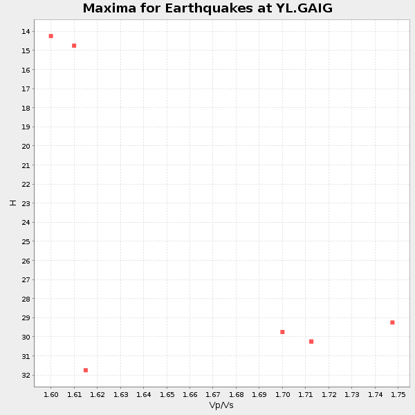
| Local Maxima 1 | 33 km | 1.61 | 6.236 km/s | 3.879 km/s | 0.18 | amp=0.043734714 |
| Local Maxima 2 | 50 km | 1.73 | 6.236 km/s | 3.615 km/s | 0.25 | amp=0.031719495 |
| Local Maxima 3 | 38 km | 1.60 | 6.236 km/s | 3.897 km/s | 0.18 | amp=0.027512359 |
| Local Maxima 4 | 28 km | 1.76 | 6.236 km/s | 3.533 km/s | 0.26 | amp=0.015399451 |
| Predicted Arrivals for vertical incidence (zero ray parameter) | |
| Ps | 3.44 SECOND |
| PpPs | 13.06 SECOND |
| PsPs/PpSs | 16.50 SECOND |
Events Processed for this Station
Download zip of receiver functions as SAC
Plot maxima for each earthquake.
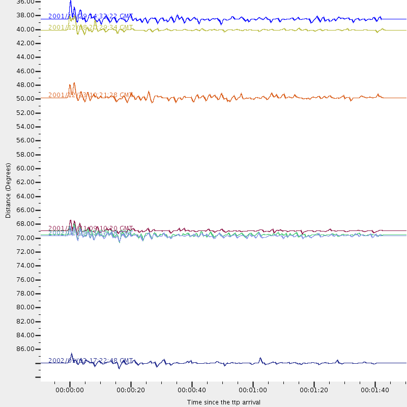
Events Used in the Stack
(7 events)| Radial Match | Distance | Baz | FERegion | Time | Lat/Lon | Depth | Magnitude |
| 94.55677 | 90.3 deg | 109.504 deg | Vanuatu Islands | 2002/01/02 17:22:48 GMT | (-17.6, 167.9) | 21 km | 6.3 MB, 7.5 MS, 7.3 MW, 7.1 MW |
| 91.31498 | 69.5 deg | 108.051 deg | New Britain Region, P.N.G. | 2001/10/31 09:10:20 GMT | (-5.9, 150.2) | 33 km | 5.9 MB, 6.9 MS, 6.9 MW, 6.9 MW |
| 90.26175 | 38.0 deg | 77.729 deg | Ryukyu Islands, Japan | 2001/12/08 20:29:34 GMT | (28.3, 129.6) | 33 km | 5.7 MB, 5.7 MS, 6.2 MW, 6.1 MW |
| 88.05743 | 70.3 deg | 107.263 deg | New Britain Region, P.N.G. | 2002/02/28 01:50:48 GMT | (-5.7, 151.3) | 40 km | 6.0 MB, 6.3 MS, 6.3 MW, 6.2 MW |
| 87.772995 | 70.1 deg | 106.961 deg | New Britain Region, P.N.G. | 2002/02/05 13:27:24 GMT | (-5.3, 151.2) | 39 km | 5.8 MB, 6.3 MS, 6.6 MW, 6.6 MW |
| 86.59137 | 36.2 deg | 151.971 deg | Southwest Of Sumatra, Indonesia | 2001/12/29 14:32:22 GMT | (-6.0, 102.8) | 33 km | 5.6 MB, 5.7 MS, 5.8 MW, 5.6 MW |
| 84.97891 | 48.6 deg | 75.475 deg | Bonin Islands, Japan Region | 2001/12/23 10:21:28 GMT | (27.9, 141.8) | 35 km | 5.7 MB, 5.6 MS, 5.9 MW, 5.8 MW |
Losers
(1 events)| Radial Match | Distance | Baz | FERegion | Time | Lat/Lon | Depth | Magnitude | Reason |
| 76.59776 | 47.0 deg | 76.375 deg | Bonin Islands, Japan Region | 2002/06/03 09:15:00 GMT | (27.6, 139.8) | 489 km | 5.0 MB, 5.9 MW, 5.9 MW |
